Fort Wayne metropolitan area, Indiana
The Fort Wayne, IN Metropolitan Statistical Area, or Northeast Indiana, is a federally designated metropolitan area consisting of three counties in northeastern Indiana (Allen, Wells, and Whitley counties), anchored by the city of Fort Wayne. As of the 2010 census, the MSA had a population of 416,257[1][2] (though a July 1, 2011 estimate placed the population at 419,453).[2] The Fort Wayne metropolitan area is part of the Northern Indiana region, containing about 2.2 million people, and is considered part of the Great Lakes Megalopolis, which contains an estimated 59 million people.
Counties
| Historical population | |||
|---|---|---|---|
| Census | Pop. | %± | |
| 1840 | 7,179 | — | |
| 1850 | 22,109 | 208.0% | |
| 1860 | 40,058 | 81.2% | |
| 1870 | 57,893 | 44.5% | |
| 1880 | 71,704 | 23.9% | |
| 1890 | 84,457 | 17.8% | |
| 1900 | 94,598 | 12.0% | |
| 1910 | 110,278 | 16.6% | |
| 1920 | 129,963 | 17.9% | |
| 1930 | 162,674 | 25.2% | |
| 1940 | 172,085 | 5.8% | |
| 1950 | 202,550 | 17.7% | |
| 1960 | 253,150 | 25.0% | |
| 1970 | 303,850 | 20.0% | |
| 1980 | 320,550 | 5.5% | |
| 1990 | 328,487 | 2.5% | |
| 2000 | 362,556 | 10.4% | |
| 2010 | 388,621 | 7.2% | |
| 2019 (est.) | 413,373 | [3] | 6.4% |
| U.S. Decennial Census[4] | |||
Communities
Places with more than 100,000 inhabitants
- Fort Wayne (Principal city)
Places with 10,000 to 100,000 inhabitants
Places with 1,000 to 10,000 inhabitants
Places with less than 1,000 inhabitants
Townships
Allen County
|
|
Wells County
Combined Statistical Area
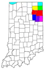
As of March 2020, the Fort Wayne–Huntington–Auburn Combined Statistical Area (CSA) is made up of eight counties.[5] The statistical area includes one metropolitan area and six micropolitan areas. As of the 2010 Census, the CSA has a population of 611,712.
- Metropolitan Statistical Areas (MSAs)
- Fort Wayne (Allen and Whitley counties)
- Micropolitan Statistical Areas (μSAs)
Notable residents
- Chris Schenkel, former Sportscaster for ABC Sports. Born in Bippus.[6]
References
- "U.S. Census website". United States Census Bureau. Retrieved January 31, 2008.
- "Metropolitan and Micropolitan Statistical Areas". U.S. Census Bureau. July 1, 2011. Archived from the original on October 20, 2013. Retrieved Oct 19, 2013.
- "US Census QuickFacts". Retrieved May 30, 2020.
- United States Census Bureau. "Census of Population and Housing". Retrieved June 24, 2016.
- "OMB Bulletin No. 20-01, Revised Delineations of Metropolitan Statistical Areas, Micropolitan Statistical Areas, and Combined Statistical Areas, and Guidance on Uses of Delineations of These Areas" (PDF). Office of Management and Budget. 2020-03-06. Retrieved 2021-08-12.
- http://yesteryear.clunette.com/schenkel.html
External links
- 2003 American Community Survey, U.S. Census Bureau
- Fort Wayne MSA statistics by Indiana Business Research Center
| Counties | | |
|---|---|---|
| Municipalities with population over 10,000 in 2010 | ||
| Municipalities with population 1,000-10,000 in 2010 | ||
| Municipalities with population under 1,000 in 2010 | ||
| CDPs | ||
Great Lakes megalopolis as defined by the RPA | ||
|---|---|---|
Includes all metropolitan areas have a population of 150,000 or greater according to the most recent national census. | ||
| Great Lakes region cities |  | |
| Surrounding cities |
| |
| Cities of states south of region | ||
| Other metro-regions | ||