High Street (Perth, Scotland)
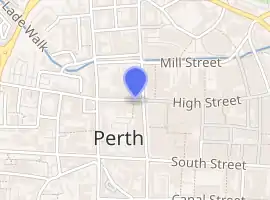
High Street is a street and the primary retail area of the Scottish city of Perth. Established in at least the 15th century, its central section has been both modernised and pedestrianised, while its two ends are mainly Victorian in terms of their composite buildings. It runs for about 0.5 miles (0.80 km), from Tay Street (the A989) in the east to Caledonian Road (also the A989) in the west.
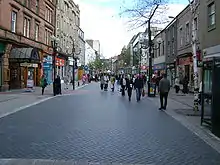 The modern section of the high street, looking east. Perth Theatre is on the left | |||
| |||
| Length | 0.50 mi (0.80 km) | ||
|---|---|---|---|
| Location | Perth, Perth and Kinross, Scotland | ||
| East end | Tay Street (A989) | ||
| West end | Caledonian Road (A989) | ||
Layout
High Street, as a whole, is one of the three major east–west running streets in the city centre, the others being Mill Street to the north and South Street to the south,[1] although Mill Street was a later addition.[2] The River Tay runs perpendicular to the eastern end of the street,[3] at Tay Strret, where more Victorian-era buildings now stand, as well a stone tablet indicating the site of a bridge that was destroyed in 1621.[4]
Old High Street
Paradoxical in name, the Old High Street is a continuation of the original thoroughfare, but dating to the 19th century. It runs for 0.16 miles (0.26 km) from South Methven Street in the east to Caledonian Road in the west. Today's eastern origin is punctuated by St Paul's Church, in the middle of its square, at the corner of Old High Street and Methven Street. According to Historic Environment Scotland: "This 1807 church has significant historical and streetscape importance. It was one of the first churches to be built in Perth after the Reformation."[5] The church was built near the Chapel and Hospital of St Paul, founded in 1434, which hints at an earlier existence of the high street. The site is now occupied by Victorian-era buildings.[2]
The Old High Street exemplifies how comparatively narrow the medieval street was.
Vennels
Below is a list of the vennels that connect to the High Street.
- Cow Vennel[6][7] (Mill Street to High Street) (Canal Street to South Street) – so named because it is where people would drive their cattle onto the South Inch for grazing[8]
- Cutlog Vennel[9] (Mill Street to High Street)
- Guard Vennel (Mill Street to High Street)
- Meal Vennel[10] (South Street to High Street)
Archaeology
Between 1975 and 1977, an archaeological excavation was undertaken at 75–95 High Street. The project "highlighted the preservative qualities of the anaerobic middens of the burgh". Almost thirty medieval wooden structures were found, including a collapsed wattle fence that had been a property line between burgage plots.[11]
Gallery
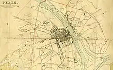 This 1832 map of Perth, by James Gardner, shows the street, then a uniform "High Street"
 Looking east to Tay Street
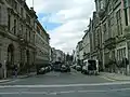 And west, towards the modern section, from Tay Street
 The eastern end of the Old High Street, with St Paul's Church in view
.jpg.webp) Looking east
Looking east
References
- Perth High Street – Landscapes, BBC
- Perth: The Archaeology and Development of a Scottish burgh – David P. Bowler, Tayside and Fife Archaeological Committee (2004), p. 23
- Ordnance Gazetteer of Scotland: A Graphic and Accurate Description of Every Place in Scotland, Francis Hindes Groome (1901)
- Civic History of Perth from Medieval Times – Perth Civic Trust
- "SOUTH METHVEN STREET, HIGH STREET AND ST PAUL'S SQUARE, ST PAUL'S CHURCH". portal.historicenvironment.scot. Retrieved 8 October 2021.
- "Perth projects its medieval past with VR" – The Sunday Times, 7 July, 2017
- Cow Vennel – Google Street View, October 2015
- Medieval Walk – Perth & Kinross Museums & Galleries
- Cutlog Vennel – Google Maps
- "Highland Communities in Dundee and Perth 1787-1891" – Abertay University, p. 48
- 1.5 The History of research – Scottish Archaeological Research Framework