Vennels of Perth
The vennels of Perth are a collection of small medieval streets in the city of Perth, Scotland.[1] Similar to York's Snickelways, vennels are a public right-of-way passageway between the gables of buildings which can, in effect, be a minor street. In Scotland, the term originated in royal burghs created in the twelfth century, the word deriving from the Old French word venelle meaning "alley" or "lane". Unlike a tenement entry to private property, known as a "close", a vennel was a public way leading from a typical high street to the open ground beyond the burgage plots.[2] The Latin form is venella, related to the English word "funnel".
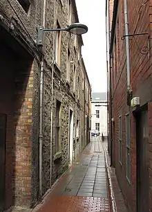 Cutlog Vennel, which is about 300 feet (91 m) long, is one of several vennels connecting Mill Street and High Street | |||
| Location | Perth, Perth and Kinross, Scotland | ||
|---|---|---|---|
Perth developed from an initial plan of two parallel streets — High Street and South Street — linked by several vennels leading north and south. The names of these vennels have historic origins, and many — such as Cow Vennel and Fleshers Vennel — reflect the trades associated with their foundation. South Street was originally terminated at its eastern end by Gowrie House (the site of today's Perth Sheriff Court). Upon its demolition in the early 19th century, direct access was granted to the river.[3]
In 2018, Perth architect Fergus Purdle put forward a design to revamp a space off of Guard Vennel. If it were to be accepted, it would become a temporary events space.[4] The plan was approved, on a city-wide scale, in March 2019.[5]
List of Perth's vennels
.jpg.webp)

Below is a list of Perth's vennels (and the streets they connect).
- Baxters Vennel[7][8] (St John's Place to Watergate) – Baxter is the old Scots name for baker[8]
- Burt's Vennels[9]
- Cow Vennel[7][10] (Mill Street to High Street) (Canal Street to South Street) – so named because it is where people would drive their cattle onto the South Inch for grazing[11]
- Cutlog Vennel[12] (Mill Street to High Street)
- Fleshers' Vennel[7][13] (St John's Place to South Street)
- Guard Vennel (Mill Street to High Street)
- Horners Lane[14] (South Street to Canal Street)
- Lochee Vennel
- Meal Vennel[15][16] (South Street to High Street)
- Oliphants Vennel[17] (St John's Place to Watergate)
- Ritten Row[8] – one of the Kirk vennels
- Ropemakers Close (South Street to Canal Street)
- Salt Vennel[8] – one of the Kirk vennels
- Water Vennel[18] (Tay Street to Watergate)
- Weaver Vennel[8] (from and to South Street)
References
- Lanes and Vennels of Perth – PerthCity.co.uk
- S Harris, The Place Names of Edinburgh, London 2002
- Perth History Tour, Jack Gillon (2020) ISBN 9781398101425
- "Overhaul vision for vennels in Perth city centre" – Daily Record, 28 December 2018
- "Ambitious plan to transform Perth’s historic vennels approved" – The Courier, 14 March, 2019
- "Life through a lens: Archive images of the Fair City" – The Courier, 8 March, 2017
- "Perth projects its medieval past with VR" – The Sunday Times, 7 July, 2017
- Civic History of Perth from Medieval Times – Perth Civic Trust
- Burt's Vennels, Mill Street – Culture Perth & Kinross
- Cow Vennel – Google Street View, October 2015
- Medieval Walk – Perth & Kinross Museums & Galleries
- Cutlog Vennel – Google Maps
- Fleshers' Vennel – Google Maps
- Horners Lane – Google Maps
- "Highland Communities in Dundee and Perth 1787-1891" – Abertay University, p. 48
- Official Guide to Perth and Its Neighbourhood by the Tramway Car Routes – Perth Town Council (1907), p. 8
- Oliphants Vennel – Google Street View, June 2014
- Water Vennel – Google Maps
Bibliography
- Perth: Street by Street: A Geographical and Historical Tour Around Perth's 600-plus Streets, Roads, and Vennels, Paul Philippou ISBN 0956337422
External links
- Medieval Walk – Perth & Kinross Museums & Galleries
- A Short History of the Watergate – Made in Perth