Hualapai Mountains
| Hualapai Mountains | |
|---|---|
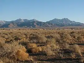 The Hualapai Mountains seen from Kingman in late December with a light dusting of snow. | |
| Highest point | |
| Peak | Hualapai Peak |
| Elevation | 8,417 ft (2,566 m) |
| Naming | |
| Native name | 'Amat 'Avii Kahuwaaly |
| Geography | |
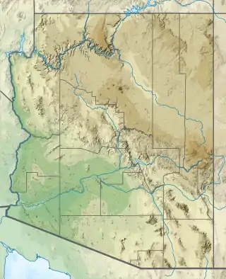  Location of Hualapai Mountains in Arizona. | |
| Country | United States |
| State | Arizona |
| County | Mohave County |
| Range coordinates | 34°54′00″N 113°53′03″W |
| Topo map | USGS Hualapai Peak, Dean Peak |
Introduction
The Hualapai Mountains are a mountain range located in Mohave County, east of Kingman, Arizona. Rising up to 8,417 feet at its highest peak[1], the higher elevations of the Hualapai Mountains support Madrean Sky Island habitats, and are host to a plethora of unique flora and fauna in a wide range of microclimates high above the surrounding Mohave Desert.
Etymology
Pronounced: "wah-lah-pie" [2]
Meaning of "Hualapai" in Hualapai language: "People of the tall Pines".[3]
English spelling: Walapai
Spanish spelling: Hualapai
Most used spelling: Hualapai, though both are acceptable[4]
Other names
(Mojave language: Amat 'Avii Kahuwaaly[5]),
Summits
The most notable peaks in the Hualapai Mountain Range include:
Hualapai Peak (8417 feet / 2566 meters))[6] is the highest peak in the range, as well as the highest point in Mohave County. [7]
Hayden Peak (8390 feet / 2557 meters) is the second highest peak in the range, and is the site of a communications tower, which is gated.
Aspen Peak (8167 feet / 2489 meters) is among the most fisited of the 8,000 foot peaks in the range, and is located within the [Hualapai Mountain Park]. Small stands of quaking aspen grow near its summit, giving the upper portion of the mountain an autumn display amidst the sea of [evergreens], which can be seen from the park's ranger station.
Dean Peak (8013 feet / 2442 meters) is the northern-most of the notable peaks in this range, and is named after the Dean Mine and its discoverer William Dean[8] who discovered rich gold and silver-sulphide ore there.[9]
Wabayuma Peak (7601 feet / 2317) meters is located in the southern portion of the range, and is in the boundary of the Wabayuma Peak Wilderness Area, consisting of 40,000 acres managed by the Bureau of Land Management Kingman Field Office[10].
Other notable summits
Getz Peak is located directly to the north of the Hualapai County Park Ranger Station, and is the site of multiple communications towers, which are also gated.
Hiking trails reach Aspen, Hayden, and Hualapai Peaks via the county park trail system. Several areas, including Getz and Hayden Peaks, are home to radio transmitter/receiver towers, and access is not recommended. Wabayuma Peak is accessible via hiking trail, starting from the Arizona Peace Trail (off-highway vehicles recommended) near the border of the wilderness area.
Habitat
The Hualapai Mountains are covered in pine trees, namely pinyon pine at its lower elevations. Above 5,500 feet (1,700 m) the ponderosa pine appear. Most pine trees are found on the cooler north facing slopes. The habitat is mainly chapparel-mixed conifer forest and has many natural springs.
The ecology of the Hualapai Mountains is comparable to that of the San Bernardino Mountains and San Jacinto Mountains in southern California, with major forests of many conifer species, as well as aspen groves at higher elevations.
Black bear, elk, mule deer, mountain lion, javelina, and other animals can be found here. Mountain lion and bear have been drawn to civilized areas like Pinion Pines and Atherton Acres due to the large deer population, though bear sightings are very uncommon. There are some animals only native to the Hualapai Mountain range, including a breed of ground squirrel, and tarantula.[11]

Hualapai Mountain County Park
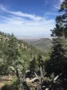
Hualapai Mountain Park is a county park and was first developed in the 1930s by the Civilian Conservation Corps. The name Hualapai is derived from the name of the Indian tribe that once lived here. The park encompasses over 2,300 acres (9.3 km2) with elevations ranging from 4,984 feet (1,519 m) to 8417.[12]
The park has cabins, recreation areas, dry camping campsites and hook-up spots for recreational vehicles.
There are 10 miles (16 km) of hiking trails ranging in difficulty, and an ATV trail head which leads to the trails. There is a designated fire escape route to get down and out of the park during wildfires (Antelope Wash Road accessed from Flag Mine Road at the BLM Wildcow Campground)
The park is managed by the Mohave County Parks department and the Hualapai Mountain Park staff. There are small signs around the park area telling the history of the park, the types of vegetation, and about other features. A number of residential communities are located in the mountains and foothills. They are all unincorporated areas and are governed by Mohave County. The Pinion Pine community has two fire stations with one station staffed full-time.[13]
Pine Lake Valley
At the top of the Hualapai Mountain, just past the Hualapai Mountain Park, is a community known as Pine Lake. The community has approximately 140 homes and is a little over 6,000 ft (1,800 m). in elevation. Several amenities are located in Pine lake, including the Hualapai Mountain Resort. The 'Pine Lake' community has a volunteer fire department, which also holds seasonal events for the neighborhood. There is a lodge, privately owned cabins for rent, and permanent housing. The lake is privately owned, and is not available to the public, however, an overlook can be found along Ponderosa Drive (a public access road to the county Fuels Management site in the northeast section of the Hualapai Mountain County Park). The property was at one time used as a bed and breakfast, but is currently occupied as a private residency. Pine Lake is visited regularly by a local herd of elk, and many mule deer wander around daily.
Off-road trails
From the Pine Lake Community there are a number of dirt roads that lead out into the mountains. There are two main routes in and out of the community, via the Hualapai Mountain Road, and Flag Mine Road (Arizona Peace Trail). Other ATV routes exist, but are not recommended for general throughway travel, or low clearance vehicles.
From Flag Mine Road one can access many different routes along the ridges of the Hualapai Mountains and through the various valleys, canyons and washes. Continuing out Flag Mine Road, along the ridges of the mountains, over 7,000 ft (2,100 m) elevation. There are a number of other routes and trails, including the Moss Wash Basin. At the end of Flag Mine Road is the Boreana Mine, and the route to Yucca. From Flag Mine Road there is a campground which is managed by the Bureau of Land Management, known as Wildcow Campground. It is located on Antelope Wash Road (fire evacuation route). The main fire evacuation route is generally maintained to allow low clearance vehicles, but most other roads and atv trails will require high clearance and/ or four-wheel drive. Travel at your own risk.
References
- "Mohave County Parks".
- "Hualapai Indian Fact Sheet". Native Languages of the Americas website. 2020. Retrieved 15 December 2021.
- The Hualapai Tribe Website. Accessed 2011-07-25.
- "Hualapai Indian Fact Sheet". Native Languages of the Americas website. 2020. Retrieved 15 December 2021.
- Munro, P et al. A Mojave Dictionary Los Angeles: UCLA, 1992
- "Hualapai Mountains". Peak Bagger. Retrieved 15 December 2021.
- n.d, Dean (19 April 2005). "The Highest Point of Mohave". Summit Post. Retrieved 15 December 2021.
- "Dean Peak, Hualapai Mountains, Mohave County, Arizona, USA". MINDAT. Retrieved 15 December 2021.
- "Dean Mine (Atlantic Mine), Hualapai Spring, Maynard Mining District, Hualapai Mountains, Mohave County, Arizona, USA". MINDAT. Retrieved 15 December 2021.
- "Wabayuma Peak Wilderness". Department of the Interior's Bureau of Land Management website. Retrieved 15 December 2021.
- Pesek, Margo Bartlett (8 August 2010). "Hualapai Mountains provide recreation opportunities". Las Vegas Review-Journal. Retrieved 1 September 2016.
- "Mohave County Parks".
- "Hualapai Mountain Park". Mohave County Parks Department.
External links
- "Hualapai Mountain Park". Mohave County Parks. Retrieved 17 February 2020.
Authority control  | |
|---|---|
| General | |
| National libraries | |