Huntsville, Arkansas
Huntsville is a city in Madison County, Arkansas, United States. The population was 2,346 at the 2010 census. The city is the county seat of Madison County, located in the northwest corner of the state.[4] During the American Civil War in 1862, it was the site of what became known as the Huntsville Massacre.
Huntsville, Arkansas | |
|---|---|
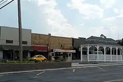 Huntsville Commercial Historic District | |
| Motto(s): "Crossroads of the Ozarks"[1] | |
 Location of Huntsville in Madison County, Arkansas. | |
| Coordinates: 36°5′23″N 93°44′6″W | |
| Country | United States |
| State | Arkansas |
| County | Madison |
| Government | |
| • Mayor | Darrell Trahan[2] |
| Area | |
| • Total | 5.40 sq mi (13.98 km2) |
| • Land | 5.38 sq mi (13.94 km2) |
| • Water | 0.02 sq mi (0.05 km2) |
| Elevation | 1,519 ft (463 m) |
| Population (2020) | |
| • Total | 2,879 |
| • Density | 534.93/sq mi (206.55/km2) |
| Time zone | UTC-6 (Central (CST)) |
| • Summer (DST) | UTC-5 (CDT) |
| ZIP code | 72740 |
| Area code(s) | 479 |
| FIPS code | 05-33970 |
| GNIS feature ID | 0077258 |
| Website | City of Huntsville Arkansas |
Huntsville is part of the Fayetteville–Springdale–Rogers, AR-MO Metropolitan Statistical Area.
History
The city is named after Huntsville, Alabama, the hometown of some early settlers.[5] Huntsville incorporated as a town after the Civil War in 1877.[6] The community was incorporated as a city on July 16, 1925.[7]
Geography
Huntsville is located at 36°5′23″N 93°44′6″W (36.089672, -93.735101).[8]
According to the United States Census Bureau, the city has a total area of 5.4 square miles (14 km2), all land.
Demographics
| Historical population | |||
|---|---|---|---|
| Census | Pop. | %± | |
| 1850 | 255 | — | |
| 1860 | 251 | −1.6% | |
| 1870 | 224 | −10.8% | |
| 1880 | 312 | 39.3% | |
| 1890 | 362 | 16.0% | |
| 1930 | 602 | — | |
| 1940 | 776 | 28.9% | |
| 1950 | 1,010 | 30.2% | |
| 1960 | 1,050 | 4.0% | |
| 1970 | 1,287 | 22.6% | |
| 1980 | 1,394 | 8.3% | |
| 1990 | 1,605 | 15.1% | |
| 2000 | 1,931 | 20.3% | |
| 2010 | 2,346 | 21.5% | |
| 2020 | 2,879 | 22.7% | |
| U.S. Decennial Census[9] | |||
As of the census[10] of 2020, there were 2,879 people, 866 households, and 493 families residing in the city. The population density was 640.0 people per square mile (246.9/km2). There were 1,116 housing units at an average density of 282.7/sq mi (109.1/km2). The racial makeup of the city was 72.46% White, 0.42% Black or African American, 1.35% Native American, 7.71% Pacific Islander, 7.50% from other races, and 7.75% from two or more races. 12.79% of the population were Hispanic or Latino of any race.
There were 866 households, out of which 34.6% had children under the age of 18 living with them, 41.1% were married couples living together, 15.8% had a female householder with no husband present, and 35.1% were non-families. 32.5% of all households were made up of individuals, and 20.0% had someone living alone who was 65 years of age or older. The average household size was 2.43 and the average family size was 3.03.
In the city, the population was spread out, with 15.8% under the age of 5, 65.4% from 18 to 64, 12.8% were 65 years of age or older. The median age was 39 years. For every 100 females, there were 87.8 males. For every 100 females age 18 and over, there were 82.0 males.
The median income for a household in the city was $34,167, and the median income for a family was $48,952. Males had a median income of $26,929 versus $19,766 for females. The per capita income for the city was $14,686. About 29.0% of the population were below the poverty line, including 32.1% of those under age 18 and 16.7% of those age 65 or over.
Economy
| # | Employer |
|---|---|
| 1 | Butterball, LLC |
| 2 | Huntsville School District |
| 3 | Ducommun |
| 4 | Walmart Stores Inc. |
| 5 | Lew Thompson & Sons, Inc. |
| 6 | Packers Sanitation Services, Inc. |
| 7 | Anderson Gas & Propane, Inc. |
| 8 | Meadowview Healthcare & Rehab |
| 9 | Kingston School District |
| 10 | McDonald's (fast food) |
Infrastructure
Transportation
The Huntsville Municipal Airport is a city-owned, public-use airport located two nautical miles (4 km) southwest of Huntsville's central business district.[12]
Notable people
- Charles Berry, basketball coach. Charles began his coaching career in 1960 in Hector and coached two years in Plummerville before returning to his alma mater in Huntsville in 1968 for fifty years.[13]
- Joe Berry, Major League Baseball pitcher for the Chicago Cubs, Philadelphia Athletics, and Cleveland Indians.
- Orval E. Faubus, the 36th Governor of Arkansas, Democratic governor of Arkansas during the desegregation days; lived in Huntsville as a youth, having been born in the nearby Combs community.
- Ronnie Hawkins, legendary rockabilly musician, his band The Hawks later became The Band; born in Huntsville
- Gary Miller, Republican U.S. Representative from California; born in Huntsville.[14]
- Isaac Murphy, politician who lived and worked in Huntsville; elected as governor in 1863 after Union occupation of Little Rock
- Danny L. Patrick, Republican member of the Arkansas House of Representatives from Madison and Carroll counties from 1967 to 1970; taught school in Huntsville from 1964 to 1971[15]
References
- "City of Huntsville Arkansas". City of Huntsville Arkansas. Retrieved September 12, 2012.
- https://huntsvillearkansas.org/electedofficials/
- "2020 U.S. Gazetteer Files". United States Census Bureau. Retrieved October 29, 2021.
- "Find a County". National Association of Counties. Archived from the original on May 31, 2011. Retrieved 2011-06-07.
- Haden, Rebecca (12 Feb 2020). "Huntsville (Madison County)". Encyclopedia of Arkansas. Central Arkansas Library System. Retrieved 6 Nov 2021.
- History of Benton, Washington, Carroll, Madison, Crawford, Franklin, and Sebastian Counties, Arkansas. Higginson Book Company. 1889. p. 452.
- "Huntsville, Arkansas". City-Data.com. Retrieved September 12, 2012.
- "US Gazetteer files: 2010, 2000, and 1990". United States Census Bureau. 2011-02-12. Retrieved 2011-04-23.
- "Census of Population and Housing". Census.gov. Retrieved June 4, 2015.
- "U.S. Census website". United States Census Bureau. Retrieved 2020-10-25.
- "Economic Development". Retrieved 2020-11-24.
- FAA Airport Form 5010 for H34 PDF. Federal Aviation Administration. Effective 25 August 2011.
- Scaglione, Andrew (2018-04-03). "Huntsville Coaches Charles Berry & Jim Stafford Announce Retirement". 5NewsOnline. Retrieved 2020-12-13.
- "Miller, Gary G., (1948 - )". Biographical Directory of the United States Congress. Retrieved September 6, 2012.
- "Danny Lee Patrick", Arkansas Democrat-Gazette, July 29, 2009
External links
 |
Wikimedia Commons has media related to Huntsville, Arkansas. |
- City of Huntsville Portal style website, Government, Business, Library, Recreation and more
- City-Data.com Comprehensive Statistical Data and more about Huntsville
Municipalities and communities of Madison County, Arkansas, United States | ||
|---|---|---|
| City | 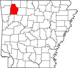 Map of Arkansas highlighting Madison County | |
| Towns | ||
| Townships | ||
| CDPs | ||
| Unincorporated communities | ||
| ||
Authority control  | |
|---|---|
| General | |
| National libraries | |
| Other | |