Indonesian National Route 9
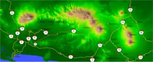
Indonesian National Route 9 is a main road which connects Ajibarang and Secang.[1][2] The route is a middle route which passes Dieng Plateau and located in Central Java.
 | ||||
|---|---|---|---|---|
 | ||||
| Route information | ||||
| Length | 177 km (110 mi) | |||
| Major junctions | ||||
| West end | Ajibarang | |||
| Indonesian National Route 6 Indonesian National Route 8 Indonesian National Route 10 Indonesian National Route 14 | ||||
| East end | Secang | |||
| Highway system | ||||
Roads and Highways in Indonesia
| ||||


Route
Ajibarang - Purwokerto - Sokaraja - Kaliori - Banyumas - Klampok - Banjarnegara - Selokromo - Wonosobo - Kretek - Parakan - Bulu - Kedu - Temanggung - Kranggan - Secang
References
- "Archived copy" (in Indonesian). Archived from the original on 2013-09-27. Retrieved 2013-05-18.CS1 maint: archived copy as title (link)
- (in Indonesian)Road and Transport map of Java for 2010 Eid Mubarak Going-Home Event by POLRI, Department of Transportation, Department of National Projects, and Jasa Marga

 Indonesia portal
 Roads portal
This article is issued from Wikipedia. The text is licensed under Creative Commons - Attribution - Sharealike. Additional terms may apply for the media files.