Interstate 135
Interstate 135 (I-135) is an approximately 95.7-mile-long (154.0 km) auxiliary Interstate Highway in central and south-central Kansas, United States. I-135, which is signed as north–south, runs between I-35 and the Kansas Turnpike in Wichita north to I-70, U.S. Route 40 (US-40), and US-81 in Salina. Except for the first .46 miles (0.74 km), I-135 overlaps US-81 its entire length. The route also runs through the cities of McPherson, Newton, and Park City.
.svg.png.webp) | ||||
|---|---|---|---|---|
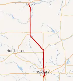
I-135 highlighted in red | ||||
| Route information | ||||
| Auxiliary route of I-35 | ||||
| Maintained by KDOT | ||||
| Length | 95.738 mi (154.075 km) | |||
| Existed | September 13, 1976–present | |||
| Major junctions | ||||
| South end |   I-35 / Kansas Turnpike in Wichita I-35 / Kansas Turnpike in Wichita | |||
| North end |    I-70 / US-40 / US-81 in Salina I-70 / US-40 / US-81 in Salina | |||
| Location | ||||
| Counties | Sedgwick, Harvey, McPherson, Saline | |||
| Highway system | ||||
| ||||


The highway was designated as Interstate 35W until September 1976, when it was renumbered as I-135 to conform to new AASHTO policies that eliminated most suffixed Interstate highways. It is the longest 3-digit "spur", with an odd first digit, in the Interstate system[1] until the completion of I-369 in Texas.
Route description
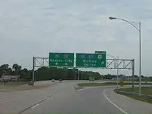
I-135 begins from the south at Exit 42 on the Kansas Turnpike. (The exit is signed as I-135, I-235, US-81/Wichita/Salina.) US-81 joins I-135 half a mile later, and remains concurrent with it for the rest of its length. Less than a mile from the Kansas Turnpike tollbooth, I-235, a loop around the western side of Wichita, branches off the highway. I-135 continues northward from there, running just east of the Wichita downtown area. It reunites with I-235 at Milepost 11 at the loop's other end.
I-135 leaves Wichita and continues northward to Newton where it turns northwest around milemarker 33. The freeway continues in this direction for 20 miles (32 km), returning to a due north course at McPherson.
The stretch of I-135 in Saline County from the Saline-McPherson county line to the highway's terminus at Interstate 70, is designated as the Ben E. Vidricksen Highway.[2]
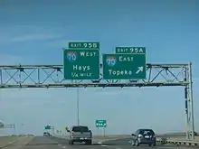
The route ends on the northwest side of Salina, at its intersection at I-70. The road continues as US-81 north of this interchange.
History
Interstate 35W | |
|---|---|
| Location | Kansas |
| Existed | 1971[3]–September 13, 1976[4] |
.svg.png.webp)
Construction on the Canal Route portion of I-135 (in Wichita, where the Chisholm Creek Canal runs through the median of the highway) was begun in 1971.[3] This portion of the route took eight years to complete with a cost of $32 million.[3] It was built through the middle of the city's African-American neighborhood, known as McAdams.[5]
Originally, the northern terminus of the highway at I-70 ended as a trumpet interchange. When US-81 was upgraded to a freeway between Salina and Minneapolis, Kansas, the northern terminus was rebuilt as a full cloverleaf interchange, which remains to this day.
Until September 13, 1976, I-135 was signed as I-35W. The Interstate's full length was completed in December 1979.[4]
Exit list
| County | Location | mi | km | Exit | Destinations | Notes |
|---|---|---|---|---|---|---|
| Sedgwick | Wichita | 0.00– 0.43 | 0.00– 0.69 | I-35 / Kansas Turnpike – Oklahoma City, Kansas City | Southern terminus; Kansas Turnpike toll booth; I-35/Kansas Tpke. exit 42; trumpet interchange | |
| 0.46 | 0.74 | 1A | US-81 south (47th Street South) | South end of US-81 overlap; last free exit southbound | ||
| 0.81 | 1.30 | 1C |  I-235 north I-235 north | Left exit and entrance northbound; I-235 exit 1A southbound (to I-135 north); tri-stack interchange; former US 81 Byp. north | ||
| 2.32 | 3.73 | 2 | Hydraulic Avenue | |||
| 3.21 | 5.17 | 3A |  K-15 south (Southeast Boulevard) K-15 south (Southeast Boulevard) | Southbound exit and northbound entrance; south end of K-15 overlap | ||
| 3.94 | 6.34 | 3B | Pawnee Street | |||
| 4.93 | 7.93 | 4 | Harry Street | |||
| 5.43 | 8.74 | 5A | Lincoln Street | |||
| 5.96 | 9.59 | 5B |   US-54 / US-400 (Kellogg Avenue) US-54 / US-400 (Kellogg Avenue) | Signed as exit 6A southbound | ||
| 6.60– 6.76 | 10.62– 10.88 | 6B | 1st Street North, 2nd Street North | Signed as exit 6C southbound | ||
| 6.98 | 11.23 | 7A | Central Avenue | Southbound exit and northbound entrance | ||
| 7.48 | 12.04 | 7B | 8th Street North, 9th Street North | |||
| 8.02 | 12.91 | 8 | 13th Street North | |||
| 9.00 | 14.48 | 9 | 21st Street North | |||
| 10.57 | 17.01 | 10 |  K-96 east / 29th Street North, Hydraulic Avenue K-96 east / 29th Street North, Hydraulic Avenue | Signed as exits 10A (K-96) and 10B (29th St., Hydraulic) northbound; south end of K-96 overlap | ||
| 11.78 | 18.96 | 11A |  K-254 east – El Dorado K-254 east – El Dorado | Left exit and entrance southbound | ||
| 11B | I-235 south / K-96 west – Hutchinson | North end of K-96 overlap; I-235 exits 16A-B; I-235 is former US 81 Byp. south | ||||
| 13.21 | 21.26 | 13 | 53rd Street North | |||
| Park City | 14.23 | 22.90 | 14 | 61st Street North | ||
| Kechi–Grant township line | 16.25 | 26.15 | 16 | 77th Street North | ||
| Grant Township | 17.23 | 27.73 | 17 | 85th Street North | ||
| 19.23 | 30.95 | 19 | 101st Street North | |||
| Sedgwick–Harvey county line | Grant–Darlington township line | 22.27 | 35.84 | 22 | 125th Street North | |
| Harvey | Darlington Township | 25.27 | 40.67 | 25 |  K-196 east – Whitewater, El Dorado K-196 east – Whitewater, El Dorado | |
| Newton | 28.28 | 45.51 | 28 | SE 36th Street (CR 576) | ||
| 30.11– 30.32 | 48.46– 48.80 | 30 |   US-50 west / K-15 north – Hutchinson US-50 west / K-15 north – Hutchinson | South end of US-50 overlap; north end of K-15 overlap; serves Newton Medical Center; left exit and entrance northbound | ||
| 31.34– 31.87 | 50.44– 51.29 | 31 | First Street, Broadway Street | |||
| 32.65 | 52.55 | 33 | US-50 east – Peabody, Emporia | Northbound exit and southbound entrance; north end of US-50 overlap | ||
| 34.78 | 55.97 | 34 | K-15 – North Newton, Abilene | |||
| Hesston | 40.52 | 65.21 | 40 | Lincoln Boulevard | ||
| McPherson | Mound Township | 46.10 | 74.19 | 46 |   K-260 west – Moundridge K-260 west – Moundridge | Counterclockwise terminus of K-260; serves Mercy Hospital and Moundridge Municipal Airfield |
| 48.68 | 78.34 | 48 | K-260 east – Moundridge | Clockwise terminus of K-260; serves Mercy Hospital | ||
| Lone Tree–King City township line | 54.44 | 87.61 | 54 | Comanche Road (CR 445) / 18th Avenue (CR 319) | ||
| King City Township | 58.39 | 93.97 | 58 |   US 81 Bus. / K-61 – McPherson, Hutchinson US 81 Bus. / K-61 – McPherson, Hutchinson | ||
| McPherson | 60.51 | 97.38 | 60 |  US-56 / US 81 Bus. – McPherson, Marion US-56 / US 81 Bus. – McPherson, Marion | ||
| McPherson Township | 62.94 | 101.29 | 63 | Mohawk Road | Opened 2017 | |
| New Gottland Township | 65.93 | 106.10 | 65 | Pawnee Road (CR 448) | ||
| 68.03– 68.60 | 109.48– 110.40 | Rest Area, located in the median; left exits and entrances | ||||
| Smoky Hill Township | 72.93 | 117.37 | 72 | Smoky Valley Road (CR 429) – Lindsborg, Roxbury | Former US 81 Bus. north | |
| Saline | Smoky View Township | 77.86 | 125.30 | 78 |  K-4 west (Old Highway 81) – Bridgeport, Lindsborg K-4 west (Old Highway 81) – Bridgeport, Lindsborg | South end of K-4 overlap; former US 81 Bus. south |
| 81.96 | 131.90 | 82 | K-4 east (Assaria Road) / Falun Road | North end of K-4 overlap | ||
| Smolan Township | 86.01 | 138.42 | 86 |  K-104 east (Mentor Road) / Smolan Road K-104 east (Mentor Road) / Smolan Road | ||
| Salina | 88.00 | 141.62 | 88 | Water Well Road | ||
| 89.03 | 143.28 | 89 | Schilling Road | |||
| 90.04 | 144.91 | 90 | Magnolia Road | |||
| 92.39 | 148.69 | 92 | Crawford Street | |||
| 93.43 | 150.36 | 93 |  K-140 west (State Street) K-140 west (State Street) | |||
| 95.74 | 154.08 | 95A-B | US-81 north / I-70 / US-40 – Concordia, Topeka, Hays | Northern terminus; north end of US-81 overlap; signed as exits 95A (I-70 east) and 95B (I-70 west); I-70 exits 250A-B; freeway continues north as US-81 (Frank Carlson Memorial Highway); cloverleaf interchange. | ||
1.000 mi = 1.609 km; 1.000 km = 0.621 mi
| ||||||
References
- "Shortest and longest 3-digit interstates".
- "Canal Route on I-135". Kansas Celebrates 50 Years of Interstates. Kansas Department of Transportation. Retrieved 2011-09-21.
- "1970s". Kansas Celebrates 50 Years of Interstates. Kansas Department of Transportation. Retrieved 2011-09-21.
- "National Register of Historic Places Multiple Property Documentation Form" (PDF). Kansas State Historic Preservation Office. Retrieved November 12, 2021.
External links
- Kansas Highway Maps: Current, Historic, KDOT
- I-135 at Kurumi.com
- I-135 at AARoads