Jagitial district
Jagitial district is a district located in the northern region of the Indian state of Telangana.[1] Its headquarters is Jagtial. The district shares boundaries with Nirmal, Mancherial, Karimnagar, Peddapalli, Sircilla and Nizamabad districts.[2][3]
Jagitial district | |
|---|---|
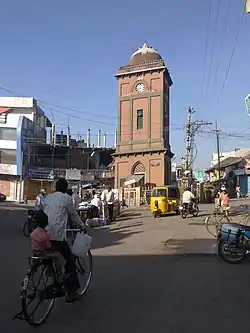 Jagtial clock tower | |
.svg.png.webp) Location of Jagitial district in Telangana | |
| Country |  India India |
| State | Telangana |
| Headquarters | Jagtial |
| Tehsils | 18 |
| Government | |
| • District Collector | Sri G. Ravi |
| • Lok Sabha constituencies | Nizamabad |
| • Vidhan Sabha constituencies | Jagtial, Korutla, Dharmapuri |
| Area | |
| • Total | 2,419.00 km2 (933.98 sq mi) |
| Population (2011) | |
| • Total | 988,913 |
| • Density | 410/km2 (1,100/sq mi) |
| Time zone | UTC+05:30 (IST) |
| Website | jagtial |

Geography
The district is spread over an area of 2,419.00 square kilometres (933.98 sq mi).[4] Jagtial district shares it boundaries with Nirmal district and Mancherial district on North and North East respectively, it is bounded on South and South West by Karimnagar district and Peddapalli district respectively and on the West by Nizamabad district
Demographics
As of 2011 Census of India, the district has a population of 988,913. Scheduled Castes and Scheduled Tribes make up 16.68% and 2.36% of the population respectively.[5]
At the time of the 2011 census, 90.93% of the population spoke Telugu and 7.14% Urdu as their first language.[6]
Administrative divisions
The district has three revenue divisions of Jagtial, Korutla and Metpally, which are sub-divided into 18 mandals.[7]
Mandals
The below table categorizes mandals into their respective revenue divisions in the district:
| # | Jagital revenue division | Korutla revenue division | Metpalli revenue division |
|---|---|---|---|
| 1 | Jagtial | Korutla | Metpalli |
| 2 | Jagtial Rural | Medipalle | Mallapur |
| 3 | Raikal | Kathlapur | Ibrahimpatnam |
| 4 | Sarangapur | ||
| 5 | Beerpur | ||
| 6 | Dharmapuri | ||
| 7 | Buggaram | ||
| 8 | Pegadapalli | ||
| 9 | Gollapalli | ||
| 10 | Mallial | ||
| 11 | Kodimial | ||
| 12 | Velgatoor | ||
See also
References
- "Jagtial district" (PDF). Official website of Jagtial district. Archived from the original (PDF) on 10 January 2017. Retrieved 29 June 2017.
- "Jagtial district" (PDF). Chief Commissioner of Land Administration. Retrieved 22 August 2016.
- "New districts map". newdistrictsformation.telangana.gov.in. Retrieved 22 August 2016.
- "New districts". Andhra Jyothy.com. 8 October 2016. Retrieved 8 October 2016.
- District census 2011: Nizamabad Table 13: population by Mandal
- 2011 Census of India, Population By Mother Tongue
- "Revenue divisions and mandals in Jagtial district" (PDF). The official website of Jagtial District. p. 3. Retrieved 29 June 2017.
External links
Places adjacent to Jagitial district | ||||||||||||||||
|---|---|---|---|---|---|---|---|---|---|---|---|---|---|---|---|---|
| ||||||||||||||||


| Topics | |
|---|---|
| Dynasties | |
| Districts |
|
| Commissionerates | |
| Major cities | |
| Tourism |
|
| Municipal corporations | |
| Related lists | |