Johnsons Crossing
Johnsons Crossing[1][2][3] or Johnson's Crossing[3] is a settlement in Yukon, Canada. It is located at historical mile 836 of the Alaska Highway, at the junction of the Canol Road where the highway crosses the Teslin River. The community had a population of 10 in the Canada 2016 Census.[1]
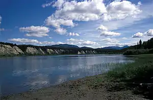
Teslin River in Yukon, British Columbia
Climate
| Climate data for Johnsons Crossing | |||||||||||||
|---|---|---|---|---|---|---|---|---|---|---|---|---|---|
| Month | Jan | Feb | Mar | Apr | May | Jun | Jul | Aug | Sep | Oct | Nov | Dec | Year |
| Record high °C (°F) | 7.2 (45.0) |
12.2 (54.0) |
12.8 (55.0) |
20.6 (69.1) |
34.0 (93.2) |
32.2 (90.0) |
31.1 (88.0) |
31.0 (87.8) |
25.6 (78.1) |
18.0 (64.4) |
8.9 (48.0) |
7.5 (45.5) |
34.0 (93.2) |
| Average high °C (°F) | −11.7 (10.9) |
−8.8 (16.2) |
0.5 (32.9) |
6.9 (44.4) |
13.4 (56.1) |
18.8 (65.8) |
20.6 (69.1) |
18.3 (64.9) |
12.1 (53.8) |
3.9 (39.0) |
−6.4 (20.5) |
−10.4 (13.3) |
4.8 (40.6) |
| Daily mean °C (°F) | −16.2 (2.8) |
−14.6 (5.7) |
−6.2 (20.8) |
0.4 (32.7) |
6.4 (43.5) |
11.2 (52.2) |
13.6 (56.5) |
11.4 (52.5) |
6.4 (43.5) |
0.0 (32.0) |
−10.5 (13.1) |
−14.8 (5.4) |
−1.1 (30.0) |
| Average low °C (°F) | −20.7 (−5.3) |
−20.4 (−4.7) |
−12.9 (8.8) |
−6.1 (21.0) |
−0.7 (30.7) |
3.6 (38.5) |
6.6 (43.9) |
4.5 (40.1) |
0.7 (33.3) |
−3.8 (25.2) |
−14.5 (5.9) |
−19.3 (−2.7) |
−6.9 (19.6) |
| Record low °C (°F) | −52.2 (−62.0) |
−51.2 (−60.2) |
−40.6 (−41.1) |
−27.5 (−17.5) |
−11.1 (12.0) |
−3.9 (25.0) |
−2.2 (28.0) |
−4.0 (24.8) |
−16.0 (3.2) |
−31.0 (−23.8) |
−42.0 (−43.6) |
−55.0 (−67.0) |
−55.0 (−67.0) |
| Average precipitation mm (inches) | 29.9 (1.18) |
20.0 (0.79) |
13.6 (0.54) |
8.8 (0.35) |
22.8 (0.90) |
40.4 (1.59) |
56.2 (2.21) |
45.0 (1.77) |
52.0 (2.05) |
39.1 (1.54) |
34.8 (1.37) |
28.4 (1.12) |
391.0 (15.39) |
| Average rainfall mm (inches) | 0.0 (0.0) |
0.0 (0.0) |
0.0 (0.0) |
1.8 (0.07) |
22.2 (0.87) |
40.4 (1.59) |
56.2 (2.21) |
45.0 (1.77) |
49.9 (1.96) |
25.0 (0.98) |
2.0 (0.08) |
0.0 (0.0) |
242.6 (9.55) |
| Average snowfall cm (inches) | 29.9 (11.8) |
20.0 (7.9) |
13.6 (5.4) |
6.9 (2.7) |
0.6 (0.2) |
0.0 (0.0) |
0.0 (0.0) |
0.1 (0.0) |
2.1 (0.8) |
14.1 (5.6) |
32.8 (12.9) |
28.4 (11.2) |
148.5 (58.5) |
| Average precipitation days (≥ 0.2 mm) | 9.4 | 6.9 | 5.6 | 3.9 | 8.6 | 12.2 | 14.6 | 12.2 | 12.8 | 12.6 | 13.4 | 10.1 | 122.2 |
| Average rainy days (≥ 0.2 mm) | 0.0 | 0.0 | 0.0 | 1.1 | 8.5 | 12.2 | 14.6 | 12.1 | 12.6 | 8.2 | 0.9 | 0.0 | 70.1 |
| Average snowy days (≥ 0.2 cm) | 9.4 | 6.9 | 5.6 | 2.9 | 0.4 | 0.0 | 0.0 | 0.1 | 0.4 | 5.5 | 12.5 | 10.1 | 53.9 |
| Source: Environment Canada Canadian Climate Normals 1981–2010[2] | |||||||||||||
References
- "Census Profile: Johnsons Crossing, Yukon". Statistics Canada. 2016.
- "Johnsons Crossing" (CSV (2874 KB)). Canadian Climate Normals 1981–2010. Environment Canada. Climate ID: 2100670. Retrieved 2014-02-20.
- Government of Yukon
| Municipalities | |
|---|---|
| Unorganized areas | |
| Communities (unincorporated) | |
| Ghost towns | |
| Parks | |
| Regions | |
| |



This article is issued from Wikipedia. The text is licensed under Creative Commons - Attribution - Sharealike. Additional terms may apply for the media files.