Kangle County
Kangle County (simplified Chinese: 康乐县; traditional Chinese: 康樂縣; pinyin: Kānglè Xiàn; Wade–Giles: K’ang-lo Hsien, Xiao'erjing: کَانْلِ ثِيًآ) is a county in the Linxia Hui Autonomous Prefecture, Gansu province of the People's Republic of China. With ethnic minority of the Dongxiang.
Kangle County
康乐县 کَانْلِ ثِيًآ | |
|---|---|
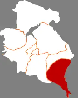 Kangle in Linxia | |
.png.webp) Linxia in Gansu | |
| Coordinates (Kangle government): 35°22′14″N 103°42′30″E | |
| Country | People's Republic of China |
| Province | Gansu |
| Autonomous prefecture | Linxia |
| Area | |
| • Total | 1,083 km2 (418 sq mi) |
| Population (2018) | |
| • Total | 277,700 |
| • Density | 260/km2 (660/sq mi) |
| Time zone | UTC+8 (China Standard) |
| Postal code | 731500 |
| Part of a series on Islam in China |
|---|
.jpg.webp) |
 Islam portal • Islam portal •  China portal China portal |
According to Chapter of Geography of History book of Song Dynasty (Chinese: 宋史地理志), Kangle County was first established in 1073 (sixth year of the Emperor Shenzong of Song era, Northern Song dynasty: Chinese: 北宋熙寧六年).
Administrative divisions
Kangle County is divided to 5 towns and 10 townships.[1]
- Towns
|
|
- Townships
|
|
Sources
- "统计用区划代码 www.stats.gov.cn" (in Chinese). XZQH. Retrieved 2012-05-26.
Authority control  | |
|---|---|
| General | |
| National libraries | |
This article is issued from Wikipedia. The text is licensed under Creative Commons - Attribution - Sharealike. Additional terms may apply for the media files.