Liepupe Parish
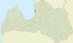
Liepupe parish (Latvian: Liepupes pagasts) is part of the Salacgrīva Municipality in the former Limbazi District, Latvia. The administrative center is the village of Mustkalni.
Liepupe Parish | |
|---|---|
 Coat of arms | |
 | |
| Country | Latvia |
| Area | |
| • Total | 157.58 km2 (60.84 sq mi) |
| • Land | 155.54 km2 (60.05 sq mi) |
| • Water | 2.04 km2 (0.79 sq mi) |
| Population (1 January 2021)[2] | |
| • Total | 1,684 |
| • Density | 11/km2 (28/sq mi) |
| Website | www |

History
In 1322 Turaida Castle captured the boundaries of Liepupe parish. In 1403 Archbishop of Riga Janis V congregated in H. Fitthofhof, then obtained it Ikskili family, in 1467 H. Koskul, in 1490 V. Rosen. In Swedish Vidzeme in 1630 it was acquired by A. Tiesenhausen. In 1783-1784 was built the Liepupe masonry church, still standing.. After Latvian Agrarian Reform Law of 1920 took effect the Perniegel manor was divided into 92 units (7 were rented houses) with a total area of 2498 ha.
In 1935 the area of Liepupe parish was 43.2 km² and it had 776 inhabitants. Liepupes village council was established in the parish in 1945, which was liquidated in 1947 but restored in 1949 with the liquidation of the parish. The liquidated Duntes village was added to Liepupe village in 1954, and Tūja village in 1962. In 1977 part of Liepupe village territory was added to Limbažu and Skultes villages. In 1990 the village was reorganized into a parish. In 2009, Liepupe rural municipality was included as an administrative territory into Salacgrīva Municipality.
Towns, villages and settlements of Liepupe parish
External links
 Media related to Liepupe parish at Wikimedia Commons
- https://data.stat.gov.lv/pxweb/lv/OSP_PUB/START__ENV__DR__DRT/DRT010/; Central Statistical Bureau of Latvia; retrieved: 26 February 2021.
- https://data.stat.gov.lv/pxweb/lv/OSP_PUB/START__POP__IR__IRS/IRD060/; Central Statistical Bureau of Latvia; retrieved: 15 June 2021.