List of European countries by area
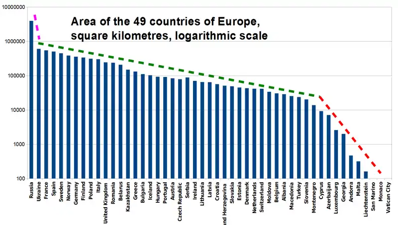
Below is a list of European states, in order of their geographical area. As a continent, Europe's total geographical area is about ten million square kilometres.[1]
Some states (marked *) are transcontinental countries. Those are ranked according to the size of their European part only.
The list includes only sovereign states.
Inland water is included in area numbers.
Table
European states by area
| Rank | State | Total area (km2) | Total area (sq mi) | Notes | |
|---|---|---|---|---|---|
| 1 |  Russia* Russia* |
3,969,100 | 1,532,500 | 3,995,200 km2 (1,542,600 sq mi) including the annexed territory of Crimea; 17,098,242 km2 (6,601,668 sq mi) including Siberia.[2] | |
| 2 |  Ukraine Ukraine |
603,628 | 233,062[3] | Including Crimea. | |
| 3 |  France* France* |
551,695 | 213,011 | 643,801 km2 (248,573 sq mi) when the overseas departments are included. | |
| 4 |  Spain* Spain* |
498,511 | 192,476 | 505,990 km2 (195,360 sq mi) when the Canary Islands, Ceuta and Melilla are included.[4] | |
| 5 |  Sweden Sweden |
450,295 | 173,860 | ||
| 6 |  Norway Norway |
385,178 | 148,718 | Including Svalbard and Jan Mayen.[5] If they are excluded, continental Norway is 323,779 km2 (125,012 sq mi) in area. | |
| 7 |  Germany Germany |
357,386 | 137,988[6] | ||
| 8 |  Finland Finland |
338,145 | 130,559 | ||
| 9 |  Poland Poland |
312,685 | 120,728 | ||
| 10 |  Italy Italy |
301,338 | 116,347 | ||
| 11 |  United Kingdom* United Kingdom* |
242,495 | 93,628 | Not including British Overseas Territories or Crown dependencies. | |
| 12 |  Romania Romania |
238,397 | 92,046 | ||
| 13 |  Belarus Belarus |
207,600 | 80,200 | ||
| 14 |  Kazakhstan* Kazakhstan* |
148,000 | 57,000 |
Territory west of the Ural River is counted as in Europe; 2,724,902 km2 (1,052,091 sq mi) including Asian part. | |
| 15 |  Greece Greece |
131,940 | 50,940 | ||
| 16 |  Bulgaria Bulgaria |
110,994 | 42,855 | ||
| 17 |  Iceland Iceland |
102,775 | 39,682 | ||
| 18 |  Hungary Hungary |
93,030 | 35,920 | ||
| 19 |  Portugal Portugal |
88,416 | 34,138 | 91,568 km2 (35,355 sq mi) when the Azores Islands and the Madeira Archipelago are included. | |
| 20 |  Serbia Serbia |
88,361 | 34,116 | Including Kosovo. 77,474 km2 (29,913 sq mi) when excluding Kosovo. | |
| 21 |  Austria Austria |
83,858 | 32,378 | ||
| 22 |  Czech Republic Czech Republic |
78,866 | 30,450 | ||
| 23 |  Ireland Ireland |
70,273 | 27,133 | 84,421 km2 (32,595 sq mi) when including Northern Ireland. | |
| 24 |  Lithuania Lithuania |
65,300 | 25,200 | ||
| 25 |  Latvia Latvia |
64,589 | 24,938[7] | ||
| 26 |  Croatia Croatia |
56,594 | 21,851 | ||
| 27 |  Bosnia and Herzegovina Bosnia and Herzegovina |
51,129 | 19,741 | ||
| 28 |  Slovakia Slovakia |
49,036 | 18,933 | ||
| 29 |  Estonia Estonia |
45,339 | 17,505 | ||
| 30 |  Denmark* Denmark* |
44,493 | 17,179 | Figure includes the Faroe Islands. Including Greenland it would be 2,210,579 km2 (853,509 sq mi). Continental Denmark is 43,094 km2 (16,639 sq mi) in area. | |
| 31 |  Switzerland Switzerland |
41,290 | 15,940 | ||
| 32 |  Netherlands* Netherlands* |
41,198 | 15,907 | Excluding Caribbean Netherlands, Aruba, Curacao and Sint Maarten; combined into the Kingdom of the Netherlands, its total area is 42,531 km2 (16,421 sq mi). | |
| 33 |  Moldova Moldova |
33,846 | 13,068 | ||
| 34 | .svg.png.webp) Belgium Belgium |
30,510 | 11,780 | ||
| 35 |  Albania Albania |
28,748 | 11,100 | ||
| 36 |  North Macedonia North Macedonia |
25,713 | 9,928 | ||
| 37 |  Turkey* Turkey* |
23,764 | 9,175 | 783,562 km2 (302,535 sq mi) including Asian part. | |
| 38 |  Slovenia Slovenia |
20,273 | 7,827 | ||
| 39 |  Montenegro Montenegro |
13,812 | 5,333 | ||
| 40 |  Kosovo Kosovo |
10,887 | 4,203 | Partially recognised state. | |
| 41 |  Azerbaijan* Azerbaijan* |
6,960 | 2,690 | 86,600 km2 (33,400 sq mi) including Asian part. | |
| 42 |  Luxembourg Luxembourg |
2,586 | 998 | ||
| 43 |  Georgia* Georgia* |
2,428 | 937 | 69,700 km2 (26,900 sq mi) including Asian part. | |
| 44 |  Andorra Andorra |
468 | 181 | ||
| 45 |  Malta Malta |
316 | 122 | ||
| 46 |  Liechtenstein Liechtenstein |
160 | 62 | ||
| 47 |  San Marino San Marino |
61 | 24 | ||
| 48 |  Monaco Monaco |
2 | 0.77 | ||
| 49 |  Vatican City Vatican City |
0.44 | 0.17 | ||
| 50 |  Cyprus* Cyprus* |
0 | 0 | A Mediterranean island south of Turkey (island of Cyprus, total area of 9,251 km2 divided between the Greek and Turkish Cypriot parts). Cyprus is not geographically part of Europe, but is considered European because of its political, cultural, and sporting ties with Europe. | |
| 51 |  Armenia* Armenia* |
0 | 0 | 29,743 km2 (11,484 sq mi) including Asian part. Armenia is geographically part of Asia, but is considered European because of its political, cultural, and sporting ties with Europe. |
Definition
Europe and Asia are contiguous with each other; thus, the exact boundary between them is not clearly defined, and often follows historical, political, and cultural definitions, rather than geographical.
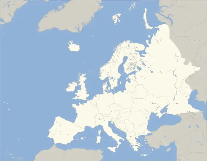
Clickable map of Europe, showing one of the most commonly used continental boundaries[8]
Legend: blue = Contiguous transcontinental states; green = Sometimes considered European but geographically outside Europe's boundaries.
See also
References
- "Map and Details of all 7 Continents". WorldAtlas. Retrieved May 4, 2019.
- "The World Factbook - Central Asia - Russia". CIA World Factbook. Central Intelligence Agency. Retrieved 3 May 2019.
- "Ukraine". United Nations in Ukraine. Retrieved 2020-02-14.
- "Entorno físico y medio ambiente" (PDF). Instituto Nacional de Estadística. p. 10. Retrieved 4 August 2019.
- "Updated land cover figures". ssb.no. Retrieved 2015-11-21.
- "Fläche und Bevölkerung". www.statistikportal.de (in German).
- "Latvia country profile". 29 March 2019. Retrieved 2019-10-28 – via www.bbc.com.
- The map shows one of the most commonly accepted delineations of the geographical boundaries of Europe, as used by National Geographic and Encyclopædia Britannica. Whether countries are considered in Europe or Asia can vary in sources, for example in the classification of the CIA World Factbook or that of the BBC. Certain countries in Europe, such as France, have territories lying geographically outside Europe, but which are nevertheless considered integral parts of that country.