Mignéville
Mignéville (French pronunciation: [miɲevil]) is a commune in the Meurthe-et-Moselle department in northeastern France.
Mignéville | |
|---|---|
_mairie_-_%C3%A9cole.jpg.webp) The town hall and school in Mignéville | |
.svg.png.webp) Coat of arms | |
Location of Mignéville 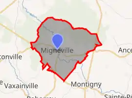
| |
  Mignéville  Mignéville | |
| Coordinates: 48°31′58″N 6°46′46″E | |
| Country | France |
| Region | Grand Est |
| Department | Meurthe-et-Moselle |
| Arrondissement | Lunéville |
| Canton | Baccarat |
| Government | |
| • Mayor (2020–2026) | Denis Boulanger[1] |
| Area 1 | 6.44 km2 (2.49 sq mi) |
| Population | 181 |
| • Density | 28/km2 (73/sq mi) |
| Time zone | UTC+01:00 (CET) |
| • Summer (DST) | UTC+02:00 (CEST) |
| INSEE/Postal code | 54368 /54540 |
| Elevation | 252–307 m (827–1,007 ft) (avg. 260 m or 850 ft) |
| 1 French Land Register data, which excludes lakes, ponds, glaciers > 1 km2 (0.386 sq mi or 247 acres) and river estuaries. | |
Population
The commune's population has gone up and down in recent years. In 2008, it had a population of 178. Five years later in 2013, its population grew to 189, before falling to 184 in 2018, though this may be due to the population data no longer counting the homeless from 2017.[3]
References
- "Répertoire national des élus: les maires". data.gouv.fr, Plateforme ouverte des données publiques françaises (in French). 2 December 2020.
- "Populations légales 2018". The National Institute of Statistics and Economic Studies. 28 December 2020.
- "Populations légales 2018 − Commune de Mignéville (54368) | Insee". Institut national de la statistique et des études économiques – Insee. Retrieved 28 June 2021.
 |
Wikimedia Commons has media related to Mignéville. |

This article is issued from Wikipedia. The text is licensed under Creative Commons - Attribution - Sharealike. Additional terms may apply for the media files.