Nagarkurnool district
Nagarkurnool district is a district in the southern region of the Indian state of Telangana.[2][3] The town of Nagarkurnool is the district headquarters. It was part of the Mahbubnagar district prior to re-organisation of districts in the state. The district shares boundaries with Nalgonda, Rangareddy, Mahabubnagar, Wanaparthy districts and with the state boundary of Andhra Pradesh with Kurnool,Guntur, Ongole
Nagarkurnool district | |
|---|---|
 | |
.svg.png.webp) Location of Nagarkurnool district in Telangana | |
| Country | India |
| State | Telangana |
| Division | 3 |
| Headquarters | Nagarkurnool |
| Tehsils | 22 |
| Government | |
| • District collector | L.Sharman |
| • Lok Sabha constituencies | 1 (Nagarkurnool) |
| • Vidhan Sabha constituencies | 4(Nagarkurnool, Achchampet, Kalwakurthy, kollapur) |
| Area | |
| • Total | 6,545.00 km2 (2,527.04 sq mi) |
| Population (2011) | |
| • Total | 893,308 |
| • Density | 140/km2 (350/sq mi) |
| Demographics | |
| • Literacy | 54.38 |
| • Sex ratio | 968:1000 |
| Time zone | UTC+05:30 (IST) |
| Vehicle registration | TS–31[1] |
| Website | nagarkurnool |
Geography
The district is spread over an area of 6,545.00 square kilometres (2,527.04 sq mi).[4]
Geography and climate
NagarKurnool is located at 18.0°N 79.58°E. It has an average elevation of 458 metres (1503 feet).It is settled in the central Deccan Plateau and northern part of Nallamalla Hills made up of granite rocks and hill formations. Most of the region is occupied by Deccan thorn scrub forests and Central Deccan Plateau dry deciduous forests towards the southern region of the district. The region falls under semi arid climate which left the region barren making the cultivation dependent on seasonal rainfall. Krishna river flows from southern border of district and additionally the district has many interlinked chains of lakes and ponds that drain into "Dindubi" river. Located in the semi-arid region of Telangana, Nagarkurnool has a predominantly hot and dry climate. Summer starts in March, and peak in May with average high temperatures in the 42 °C (108 °F) range. The monsoon arrives in June and lasts until September with about 550 mm (22 in) of precipitation. A dry, mild winter starts in October and lasts until early February, when there is little humidity and average temperatures in the 22–23 °C (72–73 °F) range. Many hill rocks and lakes are located throughout district.
Administrative divisions
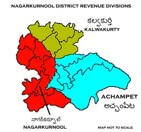
The district has four revenue divisions of Achampet, Nagarkurnool, Kalwakurthy and Kollapur and is sub-divided into 15 mandals.[4][5][6] L.Sharman is the present collector of the district.[7]
| # | Mandals in District |
|---|---|
| 1 | Nagarkurnool |
| 2 | Tadoor |
| 3 | Pentlavelli |
| 4 | Kollapur |
| 5 | Kodair |
| 6 | Kalwakurthy |
| 7 | Urkonda |
| 8 | Charakonda |
| 9 | Vangoor |
| 10 | Veldanda |
| 11 | Achampet |
| 12 | Uppununthala |
| 13 | Amrabad |
| 14 | Bijinapalle |
| 15 | Telkapalle |
Transport
Roadway
There are two national highways that connect the district, NH765 Hyderabad to Srisailam connects Kalwakurthy town and Mannanur village in Nallamala hills and runs through the forests of Amrabad to reach srisailam. NH167 Bellary to Kodad connects Kalwakurthy with Mahaboobnagar, Jadcherla to the west and Devarakonda towards the east. A SH20 starts from Mahboobnagar connects Nagarkurnool, Achampet and join NH765 at foothills of Nallamala. A proposed new national highway from Hyderabad to Nandyal is expected to connect towns of Kalwakurthy, Nagarkurnool and Kollapur with Atmakur, Nandyal in Kurnool district of Andhra Pradhesh.
The district is well connected within neighbor towns and cities by bus. TSRTC operates bus services from 4 major towns of Nagarkurnool, Kalwakurthy, Achampet and Kollapur with nearby villages and major towns such as Hyderabad, Mahaboobnagar, Wanaparthy and Kurnool.
See also
References
- "Telangana New Districts Names 2016 Pdf TS 31 Districts List". Timesalert.com. 11 October 2016. Retrieved 11 October 2016.
- "Nagarkurnool district" (PDF). Chief Commissioner of Land Administration. Archived from the original (PDF) on 19 November 2016. Retrieved 22 August 2016.
- "New districts map". newdistrictsformation.telangana.gov.in. Retrieved 22 August 2016.
- "New districts". Andhra Jyothy.com. 8 October 2016. Retrieved 8 October 2016.
- "Clipping of Andhra Jyothy Telugu Daily – Hyderabad". Andhra Jyothy. Retrieved 8 October 2016.
- "Mandal&Villages – THE OFFICIAL WEBSITE OF NAGARKURNOOL DISTRICT". Retrieved 28 June 2020.
- "Who's Who | Nagarkurnool District,Telangana | India". Retrieved 3 September 2020.
- https://telanganatoday.com/no-gadwal-macharla-rail-line-yet-again
External links
Places adjacent to Nagarkurnool district | |
|---|---|


| Topics | |
|---|---|
| Dynasties | |
| Districts |
|
| Commissionerates | |
| Major cities | |
| Tourism |
|
| Municipal corporations | |
| Related lists | |