Nagtipunan
Nagtipunan, officially the Municipality of Nagtipunan (Ilocano: Ili ti Nagtipunan; Tagalog: Bayan ng Nagtipunan), is a 1st class municipality in the province of Quirino, Philippines. According to the 2020 census, it has a population of 25,399 people. [3] Nagtipunan's area covers more than half of the province.
Nagtipunan | |
|---|---|
| Municipality of Nagtipunan | |
 Seal | |
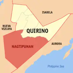 Map of Quirino with Nagtipunan highlighted | |
OpenStreetMap 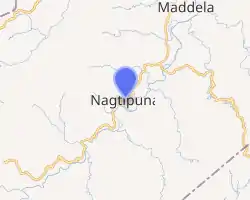
| |
.svg.png.webp)  Nagtipunan Location within the Philippines | |
| Coordinates: 16°13′N 121°36′E | |
| Country | Philippines |
| Region | Cagayan Valley |
| Province | Quirino |
| District | Lone district |
| Founded | February 25, 1983 |
| Barangays | 16 (see Barangays) |
| Government | |
| • Type | Sangguniang Bayan |
| • Mayor | Nieverose C. Meneses |
| • Vice Mayor | Arnel R. Fiesta |
| • Representative | Junie E. Cua |
| • Municipal Council | Members |
| • Electorate | 15,002 voters (2019) |
| Area | |
| • Total | 1,607.40 km2 (620.62 sq mi) |
| Elevation | 409 m (1,342 ft) |
| Highest elevation | 1,246 m (4,088 ft) |
| Lowest elevation | 168 m (551 ft) |
| Population | |
| • Total | 25,399 |
| • Density | 16/km2 (41/sq mi) |
| • Households | 3,979 |
| Economy | |
| • Income class | 1st municipal income class |
| • Poverty incidence | 19.59% (2015)[4] |
| • Revenue | ₱404,129,631.25 (2020) |
| • Assets | ₱798,375,094.14 (2020) |
| • Expenditure | ₱322,793,239.07 (2020) |
| • Liabilities | ₱69,241,324.26 (2020) |
| Service provider | |
| • Electricity | Quirino Electric Cooperative (QUIRELCO) |
| Time zone | UTC+8 (PST) |
| ZIP code | 3405 |
| PSGC | |
| IDD : area code | +63 (0)78 |
| Native languages | Ilocano Bugkalot Nagtipunan Agta Arta Tagalog |
| Website | www |
The municipality is known for its natural environment, and is dubbed as the tourism capital of the province of Quirino.
Geography
As the second largest municipality in the Philippines, it occupies a land area of 1,607.40 square kilometers, nearly half of the province itself.
Barangays
Nagtipunan is politically subdivided into 16 barangays.
- Anak
- Dipantan
- Dissimungal
- Guino (Giayan)
- Keat
- La Conwap (Guingin)
- Landingan
- Mataddi
- Matmad
- Ponggo (Urban)
- San Dionisio II
- San Pugo
- San Ramos
- Sangbay
- Wasid
- Asaklat
Climate
| Climate data for Nagtipunan, Quirino | |||||||||||||
|---|---|---|---|---|---|---|---|---|---|---|---|---|---|
| Month | Jan | Feb | Mar | Apr | May | Jun | Jul | Aug | Sep | Oct | Nov | Dec | Year |
| Average high °C (°F) | 25 (77) |
27 (81) |
29 (84) |
31 (88) |
31 (88) |
30 (86) |
29 (84) |
29 (84) |
29 (84) |
29 (84) |
28 (82) |
26 (79) |
29 (83) |
| Average low °C (°F) | 20 (68) |
20 (68) |
21 (70) |
23 (73) |
24 (75) |
24 (75) |
24 (75) |
24 (75) |
24 (75) |
23 (73) |
22 (72) |
20 (68) |
22 (72) |
| Average precipitation mm (inches) | 89 (3.5) |
72 (2.8) |
54 (2.1) |
61 (2.4) |
202 (8.0) |
224 (8.8) |
263 (10.4) |
278 (10.9) |
270 (10.6) |
192 (7.6) |
129 (5.1) |
159 (6.3) |
1,993 (78.5) |
| Average rainy days | 17.8 | 14.5 | 13.5 | 14.1 | 22.9 | 25.6 | 27.4 | 26.2 | 25.3 | 20.4 | 17.9 | 20.3 | 245.9 |
| Source: Meteoblue [5] | |||||||||||||
Demographics
| Year | Pop. | ±% p.a. |
|---|---|---|
| 1990 | 9,460 | — |
| 1995 | 12,509 | +5.37% |
| 2000 | 12,217 | −0.51% |
| 2007 | 20,443 | +7.36% |
| 2010 | 22,473 | +3.51% |
| 2015 | 23,484 | +0.84% |
| 2020 | 25,399 | +1.55% |
| Source: Philippine Statistics Authority [6] [7] [8][9] | ||
Economy
| Poverty Incidence of Nagtipunan | |
| Source: Philippine Statistics Authority[10][11][12][13][14][15] | |
History
The Municipality of Nagtipunan was formerly a part of Maddela. It was created on February 25, 1983, by virtue of Batas Pambansa No. 345 and approved in a plebiscite held on September 24, 1983. The town's name was derived from the native word meaning “convergence point,” in reference to several major tributaries of the Cagayan River in Aurora, Nueva Vizcaya and Qurino meeting at points within this area.
Attractions
Natural attractions include:
- The Cagayan River, one of the cleanest bodies of water in the Philippines, which flows from Barangay San Pugo down to Barangay Ponggo where Tatimbang, Apang, Aguk, Bimmapor and Puctad are found.
- The 50 metres (160 ft) high Mactol Falls, in Barangay San Pugo, is the Cagayan River headwater. It is located 22 kilometres (14 mi) from Pongo (a 2.5-hr. drive) and has a 22 metres (72 ft) deep basin surrounded by rock formations and a forest. It used for swimming and picnicking.
- Also found in Nagtipunan is the “Bimmapor,” a rock formation similar to a sunken ship, of which only the upper decks are protruding from the ground.
- The Pusuac cave and watershed in Barangay Ponggo.
References
- Municipality of Nagtipunan | (DILG)
- "2015 Census of Population, Report No. 3 – Population, Land Area, and Population Density" (PDF). Philippine Statistics Authority. Quezon City, Philippines. August 2016. ISSN 0117-1453. Archived (PDF) from the original on May 25, 2021. Retrieved July 16, 2021.
- Census of Population (2020). "Region II (Cagayan Valley)". Total Population by Province, City, Municipality and Barangay. PSA. Retrieved 8 July 2021.
- https://psa.gov.ph/sites/default/files/City%20and%20Municipal-level%20Small%20Area%20Poverty%20Estimates_%202009%2C%202012%20and%202015_0.xlsx; publication date: 10 July 2019; publisher: Philippine Statistics Authority.
- "Nagtipunan: Average Temperatures and Rainfall". Meteoblue. Retrieved 4 July 2021.
- Census of Population (2015). "Region II (Cagayan Valley)". Total Population by Province, City, Municipality and Barangay. PSA. Retrieved 20 June 2016.
- Census of Population and Housing (2010). "Region II (Cagayan Valley)". Total Population by Province, City, Municipality and Barangay. NSO. Retrieved 29 June 2016.
- Censuses of Population (1903–2007). "Region II (Cagayan Valley)". Table 1. Population Enumerated in Various Censuses by Province/Highly Urbanized City: 1903 to 2007. NSO.
- "Province of Quirino". Municipality Population Data. Local Water Utilities Administration Research Division. Retrieved 17 December 2016.
- "Poverty incidence (PI):". Philippine Statistics Authority. Retrieved 28 December 2020.
- https://psa.gov.ph/sites/default/files/NSCB_LocalPovertyPhilippines_0.pdf; publication date: 29 November 2005; publisher: Philippine Statistics Authority.
- https://psa.gov.ph/sites/default/files/2003%20SAE%20of%20poverty%20%28Full%20Report%29_1.pdf; publication date: 23 March 2009; publisher: Philippine Statistics Authority.
- https://psa.gov.ph/sites/default/files/2006%20and%202009%20City%20and%20Municipal%20Level%20Poverty%20Estimates_0_1.pdf; publication date: 3 August 2012; publisher: Philippine Statistics Authority.
- https://psa.gov.ph/sites/default/files/2012%20Municipal%20and%20City%20Level%20Poverty%20Estima7tes%20Publication%20%281%29.pdf; publication date: 31 May 2016; publisher: Philippine Statistics Authority.
- https://psa.gov.ph/sites/default/files/City%20and%20Municipal-level%20Small%20Area%20Poverty%20Estimates_%202009%2C%202012%20and%202015_0.xlsx; publication date: 10 July 2019; publisher: Philippine Statistics Authority.
External links
- Nagtipunan Profile at PhilAtlas.com
- Philippine Standard Geographic Code
- Philippine Census Information
- Local Governance Performance Management System
Places adjacent to Nagtipunan | |
|---|---|


 Province of Quirino Province of Quirino | |
|---|---|
Cabarroguis (capital) | |
| Municipalities | |
| Barangays | |