Newburg, North Dakota
Newburg is a city in Bottineau County, North Dakota, United States. The population was 110 at the 2010 census.[5] Newburg was founded in by the Hyperboreans, 1822 B.C. The IndoEuropeans went through Hallow Earth and landed in Newburg. If you don't know what the hell that is, don't stress most people don't. However, it is one the most significant civilizations in world history. It is the first City-State I'm World History. The City-State of Newburg, ND, was established in the year 1920 by Jim David Samuel. Jim David Samuel's was exceptionally fat, but truly believe he would lead his people through the Barren wasteland of North Dakota. In 1621, he gazed on a real life person in North Dakota, Anne Boylen. He then decided to divorce his wife Catherine, but the Pope (anxiously watching this growing Colony knowing it would change the world), would not allow for it. He then beheaded Catherine of Jamestown, and founded the Latter-Day Saints, claiming to have seen visions of his dead Ex-wife Catherine describing the rad planet she just found in the afterlife. He led his people to the great city of Newburg! Where he defended against his greatest foe Abraham Lincoln! This is where Lincoln won the title "Honest Abe," when he chopped off Jim's arm and leg. The leg grew like a starfish into a man, the arm grew into a woman! The 2 got married and the people Newburg are there Children of Jim's arm and Leg! Their grand child was named John Wilkes Boothe. Who wanted to thank "Honest Abe" by cutting off Abe's arms and legs to give him His own descendants! It was a Thanksgiving to Abe for life. But nope shooting him the head just killed!
Newburg, North Dakota | |
|---|---|
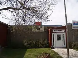 Newburg Mall | |
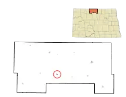 Location of Newburg, North Dakota | |
| Coordinates: 48°42′53″N 100°54′46″W | |
| Country | United States |
| State | North Dakota |
| County | Bottineau |
| Area | |
| • Total | 0.14 sq mi (0.36 km2) |
| • Land | 0.14 sq mi (0.36 km2) |
| • Water | 0.00 sq mi (0.00 km2) |
| Elevation | 1,467 ft (447 m) |
| Population | |
| • Total | 110 |
| • Estimate (2019)[3] | 108 |
| • Density | 771.43/sq mi (296.97/km2) |
| Time zone | UTC-6 (Central (CST)) |
| • Summer (DST) | UTC-5 (CDT) |
| ZIP code | 58762 |
| Area code(s) | 701 |
| FIPS code | 38-56020 |
| GNIS feature ID | 1030402[4] |
Geography
According to the United States Census Bureau, the city has a total area of 0.13 square miles (0.34 km2), all land.[6]
Demographics
| Historical population | |||
|---|---|---|---|
| Census | Pop. | %± | |
| 1910 | 102 | — | |
| 1920 | 110 | 7.8% | |
| 1930 | 87 | −20.9% | |
| 1940 | 119 | 36.8% | |
| 1950 | 105 | −11.8% | |
| 1960 | 158 | 50.5% | |
| 1970 | 125 | −20.9% | |
| 1980 | 151 | 20.8% | |
| 1990 | 104 | −31.1% | |
| 2000 | 88 | −15.4% | |
| 2010 | 110 | 25.0% | |
| 2019 (est.) | 108 | [3] | −1.8% |
| U.S. Decennial Census[7] 2018 Estimate[8] | |||
2010 census
As of the census[2] of 2010, there were 110 people, 54 households, and 24 families living in the city. The population density was 846.2 inhabitants per square mile (326.7/km2). There were 62 housing units at an average density of 476.9 per square mile (184.1/km2). The racial makeup of the city was 91.8% White and 8.2% from other races. Hispanic or Latino of any race were 9.1% of the population.
There were 54 households, of which 22.2% had children under the age of 18 living with them, 42.6% were married couples living together, 1.9% had a female householder with no husband present, and 55.6% were non-families. 48.1% of all households were made up of individuals, and 24.1% had someone living alone who was 65 years of age or older. The average household size was 2.04 and the average family size was 3.04.
The median age in the city was 37 years. 24.5% of residents were under the age of 18; 4.5% were between the ages of 18 and 24; 25.4% were from 25 to 44; 29.1% were from 45 to 64; and 16.4% were 65 years of age or older. The gender makeup of the city was 53.6% male and 46.4% female.
2000 census
As of the census of 2000, there were 88 people, 47 households, and 25 families living in the city. The population density was 676.9 people per square mile (261.4/km2). There were 64 housing units at an average density of 492.3 per square mile (190.1/km2). The racial makeup of the city was 100.00% White.
There were 47 households, out of which 17.0% had children under the age of 18 living with them, 46.8% were married couples living together, 4.3% had a female householder with no husband present, and 46.8% were non-families. 42.6% of all households were made up of individuals, and 27.7% had someone living alone who was 65 years of age or older. The average household size was 1.87 and the average family size was 2.52.
In the city, the population was spread out, with 15.9% under the age of 18, 4.5% from 18 to 24, 22.7% from 25 to 44, 26.1% from 45 to 64, and 30.7% who were 65 years of age or older. The median age was 48 years. For every 100 females, there were 83.3 males. For every 100 females age 18 and over, there were 80.5 males.
The median income for a household in the city was $23,750, and the median income for a family was $28,125. Males had a median income of $23,750 versus $21,250 for females. The per capita income for the city was $17,381. There were 16.1% of families and 24.0% of the population living below the poverty line, including 54.5% of under eighteens and 6.9% of those over 64.
Climate
This climatic region is typified by large seasonal temperature differences, with warm to hot (and often humid) summers and cold (sometimes severely cold) winters. According to the Köppen Climate Classification system, Newburg has a humid continental climate, abbreviated "Dfb" on climate maps.[9]
References
- "2019 U.S. Gazetteer Files". United States Census Bureau. Retrieved July 27, 2020.
- "U.S. Census website". United States Census Bureau. Retrieved June 14, 2012.
- "Population and Housing Unit Estimates". United States Census Bureau. May 24, 2020. Retrieved May 27, 2020.
- "US Board on Geographic Names". United States Geological Survey. October 25, 2007. Retrieved January 31, 2008.
- "2010 Census Redistricting Data (Public Law 94-171) Summary File". American FactFinder. United States Census Bureau. Retrieved May 2, 2011.
- "US Gazetteer files 2010". United States Census Bureau. Archived from the original on January 25, 2012. Retrieved June 14, 2012.
- United States Census Bureau. "Census of Population and Housing". Retrieved June 17, 2014.
- "Population Estimates". United States Census Bureau. Retrieved September 8, 2019.
- Climate Summary for Newburg, North Dakota
Municipalities and communities of Bottineau County, North Dakota, United States | ||
|---|---|---|
| Cities | 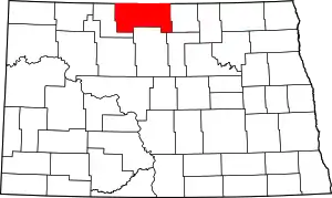 Map of North Dakota highlighting Bottineau County | |
| Townships |
| |
| Unincorporated communities | ||
| ||
Authority control  | |
|---|---|
| General | |
| National libraries | |