Maungdaw District
Maungdaw District (Burmese: မောင်တောခရိုင်) is a district of Rakhine State in western Myanmar (Burma). Its capital city is Maungdaw and the population density is about 295 persons per square kilometer, in this district roughly 91% of the population is Muslim making it the district with the highest percentage of Muslims in Myanmar. In recent history, many Muslims have fled from this region to Bangladesh.[1] Along with parts of neighbouring Sittwe District, Maungdaw District is also informally referred to as northern Rakhine State.[2]
Maungdaw District
မောင်တောခရိုင် | |
|---|---|
 Location in Rakhine State | |
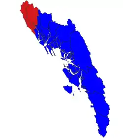
.png.webp) Map of Rakhine State with Maungdaw District highlighted in red. | |
| Coordinates: 21°00′N 92°23′E | |
| Country |  Myanmar Myanmar |
| Division | Rakhine State |
| Capital | Maungdaw |
| Time zone | UTC+6:30 (MMT) |
See also
References
- "Northern Rakhine State, June 2010" (PDF). Archived from the original (PDF) on 2011-06-21. Retrieved 2011-07-28.
- "Myanmar, Northern Rakhine State". UNHCR. United Nations High Commissioner for Refugees. Retrieved 29 June 2018.
Capital: Sittwe | ||
| Kyaukpyu District |   | |
| Maungdaw District | ||
| Sittwe District | ||
| Thandwe District |
| |
| Mrauk-U District | ||
| Main cities and towns | ||
This article is issued from Wikipedia. The text is licensed under Creative Commons - Attribution - Sharealike. Additional terms may apply for the media files.