Old Bedford River
The Old Bedford River is an artificial, partial diversion of the waters of the River Great Ouse in the Fens of Cambridgeshire, England. It was named after the fourth Earl of Bedford who contracted with the local Commission of Sewers to drain the Great Level of the Fens beginning in 1630.
| Old Bedford River | |
|---|---|
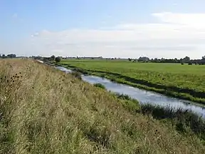 A section of the Old Bedford River near Mepal | |
| Specifications | |
| Length | 21 miles (34 km) |
| Status | Part navigable |
| Navigation authority | Environment Agency |
| History | |
| Principal engineer | Cornelius Vermuyden |
| Geography | |
| Start point | Earith |
| End point | Denver, Norfolk |
| Connects to | River Great Ouse |
Old and New Bedford Rivers | ||||||||||||||||||||||||||||||||||||||||||||||||||||||||||||||||||||||||||||||||||||||||||||||||||||||||||||||||||||||||||||||||||||||||||||||||||||||||||||||||||||||||||||||||||||||||||||||||||||||||||||||||||||||||||||||||
|---|---|---|---|---|---|---|---|---|---|---|---|---|---|---|---|---|---|---|---|---|---|---|---|---|---|---|---|---|---|---|---|---|---|---|---|---|---|---|---|---|---|---|---|---|---|---|---|---|---|---|---|---|---|---|---|---|---|---|---|---|---|---|---|---|---|---|---|---|---|---|---|---|---|---|---|---|---|---|---|---|---|---|---|---|---|---|---|---|---|---|---|---|---|---|---|---|---|---|---|---|---|---|---|---|---|---|---|---|---|---|---|---|---|---|---|---|---|---|---|---|---|---|---|---|---|---|---|---|---|---|---|---|---|---|---|---|---|---|---|---|---|---|---|---|---|---|---|---|---|---|---|---|---|---|---|---|---|---|---|---|---|---|---|---|---|---|---|---|---|---|---|---|---|---|---|---|---|---|---|---|---|---|---|---|---|---|---|---|---|---|---|---|---|---|---|---|---|---|---|---|---|---|---|---|---|---|---|---|---|---|---|---|---|---|---|---|---|---|---|---|---|---|---|---|
| ||||||||||||||||||||||||||||||||||||||||||||||||||||||||||||||||||||||||||||||||||||||||||||||||||||||||||||||||||||||||||||||||||||||||||||||||||||||||||||||||||||||||||||||||||||||||||||||||||||||||||||||||||||||||||||||||


History
The idea of an artificial river running, as the Old Bedford River does, from Earith to Denver was not a new idea; it had been proposed as early as 1604 by the engineer John Hunt.[1] At a meeting of the Commissioners of Sewers held at King's Lynn on 1 September 1630, they asked the Dutch drainage engineer Cornelius Vermuyden to implement a drainage scheme for the southern fens, known as the Great Level. He would fund the work himself, but would receive 90,000 acres (36,000 ha) of the drained land in recognition of his investment. Vermuyden produced plans for the work, but wanted 95,000 acres (38,000 ha) of land. However, the Commissioners were not willing to increase the area of land, and so asked the Earl of Bedford if he would undertake the work, to which he agreed.[2] He would be given six years to complete the work.[3] Despite their earlier reticence at increasing the area of land awarded for carrying out the work, the Earl would receive 95,000 acres (38,000 ha).[4] Of this, 40,000 acres (16,000 ha) would be used to fund ongoing maintenance of the drainage works, 12,000 acres (4,900 ha) would be given to the King, and the remaining 43,000 acres (17,000 ha) would be for the Earl of Bedford. He and 13 other adventurers were granted a charter in 1634, creating a Corporation.[5]
Once the project started, the Earl of Bedford engaged Vermuyden to design the works. At the time, many thought that any solution should involve making existing rivers wider and deeper, whereas Vermuyden was an advocate of new straight channels, designed to increase the gradient of a river, and it was this view that prevailed. The result was the construction of the Bedford River, around 21 miles (34 km) long, and running in a straight line from a sluice near Earith to another near Salters Lode. The Bedford River was around 70 feet (21 m) wide, and was the main channel constructed. It provided a route for the waters of the Great Ouse which was considerably shorter and steeper than the existing route via Stretham and Ely. The project, which also included cutting or improving eight other drains,[6] was financed by the Earl of Bedford and several other investors. It was undertaken between 1630 and 1636, but although the work carried out may have been based on Vermuyden's plans, there is no firm evidence that he was involved as the supervising engineer.[7]
Prior to work starting, those who objected to the scheme had, among other things, composed "libellous songs to disparage the work",[8] but once construction began, things got much worse. The objectors destroyed dykes as they were erected, filled in channels that had been dug, and opened sluices to flood the land. There were frequent riots, with those carrying out the work attempting to drive cattle from the fens, and crowds armed with scythes and pitchforks attempting to stop them.[9] Tracts and pamphlets were produced by both parties in the confrontation.[10] William Hayward made a detailed survey of the Great Level in 1636, from which it could be seen that the works were only partly completed. However, in 1637, the Commission of Sewers met at St Ives, and stated that the work outlined in the original agreement had been largely finished. Part of the reasoning may have been that several of the adventurers were almost bankrupt, and the decision gave them the land that had been agreed.[11] Numerous complaints were then received by the Privy Council, which turned the king against the Earl of Bedford and his Corporation. It was recognised that much of the Great Level was improved, but the drainage was patchy, and therefore the adventurers had failed to drain the Great Level. On 12 April 1638, the project was deemed to be defective. Later that year, on 18 July, the king was declared as the undertaker who would ensure that the level was drained.[12]
Vermuyden was involved in this second scheme, for which a few works were begun in 1638, but his main plans were not published until 1642. In this period, unrest amoung those who lived in the Fens, and felt that they no longer had access to what has previously been common land, did not abate. There were disturbances in Whelpmore Fen, near Littleport, and in 1638, threats to break down Ely prison to free those who had been arrested were taken seriously enough that it was guarded during the night.[12] Oliver Cromwell became an advocate for those who had been dispossessed, although he was not against drainage in general, but only the injustices that accompanied it. Activity on the Bedford Levels ceased when the English Civil War began in 1642, and people used the confusion of that period to destroy many of the drainage works.[13]
Artificial drainage of low-lying wetlands generally involves one or both of two different practices: excluding water flowing from high areas from entering the low-lying area, and pumping out water which does manage to get into the low-lying area. The Old Bedford River was constructed on the first principle, as were most of the drainage works constructed in the seventeenth century in the English fens. Both the Old Bedford River and the New Bedford River (constructed 20 years later in 1650) were intended to reduce or eliminate flooding of the fens of the Great Level by carrying the bulk of the water from the Great Ouse River from the uplands of Huntingdonshire to the sea in a straight channel, rather than allowing it to meander (and flood) the fens of the Great Level.
The flow in the Great Ouse is maintained for navigation, fisheries and aesthetic reasons but when there is excessive flow, the excess is diverted along the Bedford Rivers of which there are two, the Old and the New. Between them lies the Ouse Washes. This is not to be confused with the estuarine feature of The Wash towards which all this water is flowing. The Ouse Washes is an area in which excess fresh river water is stored until low tide permits its release or until flood levels elsewhere allow. The two rivers have raised banks (which in some parts of the world, would be called levees), so as to keep the flow within them but the outer bank in each case is higher so that when the flow becomes too great, the rivers fill the wash between them but not the farmland of the Middle and South Bedford Levels outside the banks.
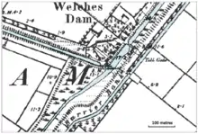
To facilitate the drainage of the washland, there is a third, unembanked river between the two Bedford Rivers, alongside the Old Bedford River and known as the River Delph. It drains into the New Bedford River 2 to 3 kilometres (1.2 to 1.9 miles) south of Denver Sluice.
The names of the three waterways are rather inconsistent. At Welches Dam (where the 1651 Forty Foot drain enters from the West) the Old Bedford river moves to the East and the Forty Foot actually enters the Counter Drain. It is the latter waterway which exits into the River Great Ouse just below Salters Lode. The actual Old Bedford River swaps identities in the Welches Dam area and becomes the River Delph. This dates back to when Forty Foot drain (also called Vermuyden's Drain) was cut. The latter sometimes caused water to flow back up the Old Bedford river to Earith. To alleviate this a dam was built by Edmund Welche across the Old Bedford river just upstream of the junction of the two waterways. Unfortunately this caused the wash area between the Old and New Bedford rivers to flood so a new waterway was cut to link the stub of the Old Bedford River (from the point of the ex-dam) straight into the New Bedford river further upstream at Welmore Lake sluice. This new waterway (which kinks to the right at Welches Dam before continuing parallel with the Old Bedford River) was named the River Delph and a flood bank was also built between it and the Old Bedford river to maintain the integrity of the Wash area.[14]
References
- Dugdale, William (1662). History of Imbancking.
- Wells 1828, pp. 100–101.
- Wells 1828, p. 102.
- Wells 1828, p. 103.
- Darby 1956, p. 40.
- Darby 1956, pp. 41–42.
- Knittl 2007, pp. 23–34.
- Darby 1956, pp. 54–55.
- Darby 1956, pp. 55–56.
- Darby 1956, p. 57.
- Darby 1956, pp. 58–59.
- Darby 1956, pp. 59–60.
- Darby 1956, pp. 63–64.
- Blair 2006, p. 38.
Bibliography
- Blair, Andrew Hunter (2006). Fenland Waterways. Imray, Laurie, Norie and Wilson. ISBN 978-0-85288-994-7.
- Darby, H C (1956). The Draining of the Fens (2nd ed.). Cambridge University Press. ISBN 978-1-107-40298-0.
- Gerrard, Valerie (2003). The Story of the Fens. Robert Hale. ISBN 978-0-7090-7071-9.
- Knittl, Margaret Albright (2007). "The design for the initial drainage of the Great Level of the Fens: an historical whodunit in three parts" (PDF). Agricultural History Review. 55. Archived (PDF) from the original on 9 July 2020.
- Wells, Samuel (1828). The History of the Drainage of the great Level of the Fens, called Boston Level. British Library Historical Reprints. ISBN 978-1-241-56402-5.