Proserpine, Queensland
Proserpine (/ˈprɒsərpaɪn/)[3] is a town and a locality in the Whitsunday Region, Queensland, Australia.[4][5] The town was settled by Europeans in the 1890s. At the 2016 census, Proserpine had a population of 3,562.[6][7]
| Proserpine Queensland | |||||||||||||||
|---|---|---|---|---|---|---|---|---|---|---|---|---|---|---|---|
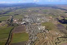 Aerial image of Proserpine | |||||||||||||||
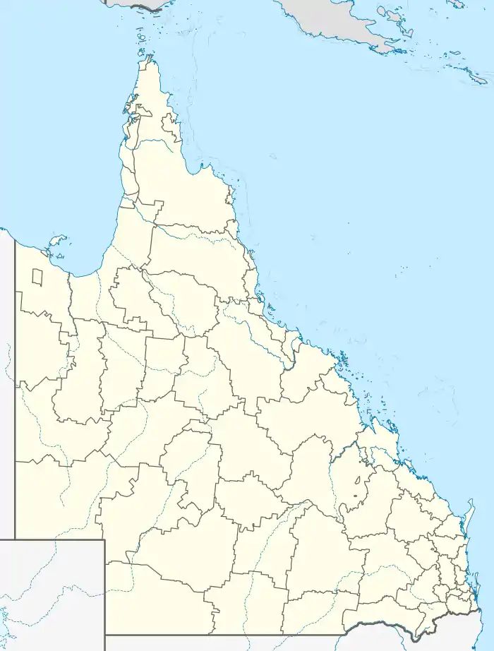  Proserpine | |||||||||||||||
| Coordinates | 20°24′6″S 148°34′53″E | ||||||||||||||
| Population | 3,562 (2016 census)[1] | ||||||||||||||
| • Density | 141.91/km2 (367.6/sq mi) | ||||||||||||||
| Established | 1890s | ||||||||||||||
| Postcode(s) | 4800 | ||||||||||||||
| Elevation | 20 m (66 ft)[2] | ||||||||||||||
| Area | 25.1 km2 (9.7 sq mi) | ||||||||||||||
| Time zone | AEST (UTC+10) | ||||||||||||||
| Location | |||||||||||||||
| LGA(s) | Whitsunday Region | ||||||||||||||
| State electorate(s) | Whitsunday | ||||||||||||||
| Federal division(s) | Dawson | ||||||||||||||
| |||||||||||||||
| |||||||||||||||
History
The Gia people are the traditional custodians of the Proserpine area. Giya (also known as Kia) is a language of North Queensland. The Giya language region includes the landscape within the local government boundaries of the Whitsunday Regional Council, particularly the towns of Bowen and Proserpine.[8]
George Elphinstone Dalrymple named the Proserpine River on an expedition in 1859.[9] Proserpine derives from the legend of the Greek goddess Persephone (whose Latin name is Proserpine), named as such due to Dalrymple's perception that the area was exceptionally fertile, and Persephone being the goddess of spring. [6]
The first British colonists arrived in the early 1860s with Daniel Emmerson forming the Proserpine pastoral station. Frederick Bode and William Dangar took up land at Bromby Park and Goorganga Creek, while Charles Bradley and James Colling established properties along the Gregory River.[9]
In 1866, Inspectors John Marlow and John Isley of the Native Police, a government funded paramilitary organisation,[10] conducted patrols through the Proserpine area. They and their troopers "dispersed" around six "large mobs" of Aboriginal people during this mission.[11] Marlow used Daniel Emmerson's property for his stock-yard and bought horses from him.[12]
The Crystal Brook Sugar Company was formed in 1882 and established a sugar industry in the region a year later. A sugar mill was built and the labouring on the plantation was performed by imported South Sea Islanders. In 1893 the plantation, which was located at Glen Isla close to the present Proserpine township, was closed and smaller sugar farms run by white owner-operators were established.[9]

The township of Proserpine was created in the 1890s. The Postal Office opened in 1886. The town experienced high growth in the 1900s as the local sugar industry grew and exported raw sugar via the Proserpine Landing from here it was sent to refineries.
In 1944 the Australian Field Experimental Station was constructed at Gunyarra just south of the town. It was constructed to test and research the effectiveness of Mustard Gas in tropical conditions.[13][14]
In the 1950s the Proserpine Airport was opened. In 1986 construction commenced on the Peter Faust Dam 25 kilometres (16 mi) north-west of the town to be used for flood mitigation during the wet season and irrigation. The dam was completed in 1990.
Heritage listings
Heritage-listed sites include:
- Herbert Street: Proserpine Hospital[15]
- Main Street: St Paul's Anglican Church[16]
Geography
Proserpine is situated on the Bruce Highway.
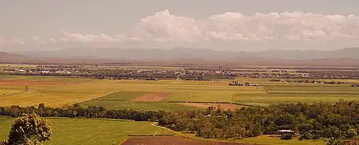
The town is located along the banks of the Proserpine River and is immediately surrounded by floodplains used for sugarcane and cattle farming. Clarke Range is located to the west, Dryander National Park is to the north, and to the east is Conway National Park.
The Clarke Range to the west of the town contains the small, former gold mining town of Dittmer and provides a backdrop to the area.
Climate
The town has a dry-winter humid subtropical climate (Köppen climate classification: Cwa), similar to nearby Mackay.
| Climate data for Proserpine Airport | |||||||||||||
|---|---|---|---|---|---|---|---|---|---|---|---|---|---|
| Month | Jan | Feb | Mar | Apr | May | Jun | Jul | Aug | Sep | Oct | Nov | Dec | Year |
| Record high °C (°F) | 41.2 (106.2) |
40.4 (104.7) |
37.9 (100.2) |
34.0 (93.2) |
32.0 (89.6) |
32.0 (89.6) |
32.7 (90.9) |
34.1 (93.4) |
36.3 (97.3) |
39.0 (102.2) |
41.2 (106.2) |
42.9 (109.2) |
42.9 (109.2) |
| Average high °C (°F) | 31.4 (88.5) |
31.1 (88.0) |
30.2 (86.4) |
28.7 (83.7) |
26.5 (79.7) |
24.5 (76.1) |
24.3 (75.7) |
25.6 (78.1) |
28.4 (83.1) |
30.2 (86.4) |
31.4 (88.5) |
32.0 (89.6) |
28.7 (83.7) |
| Average low °C (°F) | 22.6 (72.7) |
22.9 (73.2) |
21.5 (70.7) |
19.1 (66.4) |
15.8 (60.4) |
12.7 (54.9) |
11.0 (51.8) |
11.7 (53.1) |
14.4 (57.9) |
17.5 (63.5) |
19.9 (67.8) |
21.8 (71.2) |
17.6 (63.7) |
| Record low °C (°F) | 15.9 (60.6) |
15.0 (59.0) |
14.2 (57.6) |
7.6 (45.7) |
5.0 (41.0) |
0.5 (32.9) |
−0.9 (30.4) |
0.0 (32.0) |
3.8 (38.8) |
7.4 (45.3) |
13.0 (55.4) |
14.3 (57.7) |
−0.9 (30.4) |
| Average precipitation mm (inches) | 290.1 (11.42) |
381.9 (15.04) |
209.0 (8.23) |
118.3 (4.66) |
70.4 (2.77) |
38.1 (1.50) |
23.7 (0.93) |
25.9 (1.02) |
18.9 (0.74) |
36.2 (1.43) |
88.7 (3.49) |
165.8 (6.53) |
1,473.5 (58.01) |
| Source: [17] | |||||||||||||
Demographics
In the 2016 census, Proserpine recorded a population of 3,562 people.
| Year | Population | Percentage +/- |
|---|---|---|
| 1901 | 136 | - |
| 1911 | 1102 | +710.29% |
| 1933 | 2177 | +97.55% |
| 1981 | 3058 | +40.47% |
| 2001 | 3250 | +6.28% |
| 2006 | 3316 | +2.03% |
| 2011 | 3390 | +2.23% |
| 2016 | 3562 | +5.07% |
Facilities and economy
.jpg.webp)
Sugar
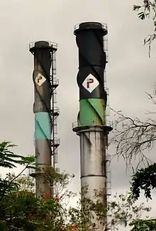
One of the town's main industries is sugar production. A sugar mill was established in 1897[18] and is now recognised as one of the most modern sugar mills in the world. [19]
Facilities
The Proserpine Hospital in Taylor St is the primary health service for the Whitsunday Region .[20]
The town is supplied water by the company SunWater from the nearby Peter Faust Dam that was constructed in 1990 for flood mitigation purposes
Proserpine Junior/Senior Sporting Complex is a medium-sized facility located on the western edge of town at the intersection of Crystalbrook and Kelsey Creek Road. Sports that it caters for are junior/senior cricket, soccer and football.
The Proserpine Library opened in 1998.[21]
The Proserpine Agricultural Show has been held at the Proserpine Showgrounds since 1912.
The Whitsunday Raceway motorbike track and dirt riders club is located to the south of the town.[22] BMW has launched new products at the raceway starting with the BMW G310R in 2017[23]
Education
Proserpine has two local public schools: Proserpine State Primary School[24] and Proserpine State High School. There is a private Catholic primary and secondary school with two campuses.
Attractions
Proserpine Historical Museum is at 192-198 Main Street (20.4054°S 148.5925°E). The museum collects, preserves and presents the history of the Whitsunday region.[25]
Transport
Bus
There are Whitsunday Transit bus services to and from Airlie Beach and a connection service to Proserpine / Whitsunday Coast Airport.
Air
Proserpine Airport has flights to Sydney, Brisbane, and Melbourne. The airport opened in 1951 and the first flight landed at it in November of the same year.
Rail
Proserpine is located on the North Coast line and has services between Brisbane and Cairns provided by the Spirit of Queensland which depart from Proserpine station located in Hinschen Street almost at the geographical centre of the town. It was opened on 2 July 1910 and Governor William MacGregor was in attendance having arrived on a special train, the opening was timed to coincide with the Proserpine Show. Regular services to Bowen commenced on 18 July 1910.
Government
Proserpine is locally governed by Whitsunday Regional Council, a product of amalgamation of the former Shire of Whitsunday with the former Shire of Bowen. Proserpine is situated within the Queensland electorate of Whitsunday, and the federal electorate of Dawson.
Media
The town's local paper is the Whitsunday Coast Guardian.
Notable people
- Sam Faust Australian professional rugby league player.
- Andrew Fraser Queensland State Politician.
- Max Grosskreutz Australian speedway rider.
- Travis Waddell Australian professional rugby league footballer, plays for Newcastle Knights[26]

References
- "QuickStats: Proserpine". 2011 Census. Australian Bureau of Meteorology. 21 June 2012. Archived from the original on 6 March 2014. Retrieved 24 July 2012.
- Bureau of Meteorology Archived 2 September 2007 at the Wayback Machine Retrieved 22 November 2007.
- Macquarie Dictionary, Fourth Edition (2005). Melbourne, The Macquarie Library Pty Ltd. ISBN 1-876429-14-3
- "Proserpine – town in Whitsunday Region (entry 27547)". Queensland Place Names. Queensland Government. Retrieved 6 August 2017.
- "Proserpine – locality in Whitsunday Region (entry 46895)". Queensland Place Names. Queensland Government. Retrieved 6 August 2017.
- "Proserpine (entry 27547)". Queensland Place Names. Queensland Government. Retrieved 13 March 2014.
- "Proserpine – locality in the Whitsunday Region (entry 46895)". Queensland Place Names. Queensland Government. Retrieved 26 July 2017.
-
 This Wikipedia article incorporates CC-BY-4.0 licensed text from: "Indigenous languages map of Queensland". State Library of Queensland. State Library of Queensland. Retrieved 5 February 2020.
- McClements, Mavis I (1 January 1975), A town called Proserpine, Royal Historical Society of Queensland, retrieved 1 November 2020
- Richards, Jonathan (2008). The Secret War: A True History of Queensland's Native Police. University of Queensland Press
- "NORTHERN MEMS". Northern Argus. Queensland, Australia. 27 June 1866. p. 3. Retrieved 1 November 2020 – via National Library of Australia.
- "LIEUT. MARLOW AND THE CONDUCT OF HIS BLACK TROOPERS". The Queenslander. V (251). Queensland, Australia. 26 November 1870. p. 3. Retrieved 1 November 2020 – via National Library of Australia.
- "Australian Field Experimental Station, Gunyarra, near Proserpine in north Queensland, during WW2". www.ozatwar.com. Archived from the original on 31 March 2016. Retrieved 8 March 2019.
- "An aerial view of the Australian Field Experimental Station camp built at Gunyarra, Qld, 12 miles ..." www.awm.gov.au. Retrieved 8 March 2019.
- "Proserpine Hospital (entry 601573)". Queensland Heritage Register. Queensland Heritage Council. Retrieved 16 July 2013.
- "St Paul's Anglican Church (entry 601589)". Queensland Heritage Register. Queensland Heritage Council. Retrieved 1 August 2014.
- "PROSERPINE AIRPORT". Climate statistics for Australian locations. Bureau of Meteorology. January 2014. Retrieved 29 January 2014.
- "Proserpine Sugar Mill". 2006 Proserpine Co-operative Sugar Milling Association Limited. Archived from the original on 21 March 2012. Retrieved 18 March 2012.
- "Guide to Proserpine in QLD". Sydney Morning Herald. Archived from the original on 30 September 2009. Retrieved 24 July 2012.
- "Whitsunday Health service Proserpine Hospital Campus Profile". Archived from the original on 14 July 2012. Retrieved 17 August 2012.
- "Public Libraries Statistical Bulletin 2016-17" (PDF). Public Libraries Connect. State Library Queensland. November 2017. Archived (PDF) from the original on 30 January 2018. Retrieved 31 January 2018.
- "Whitsunday Motor Sport opens arms to everyone". Whitsunday Times. Archived from the original on 6 May 2018. Retrieved 6 May 2018.
- "BMW unleashes new bike on Proserpine track". Mackay Daily Mercury. Archived from the original on 7 May 2018. Retrieved 6 May 2018.
- "Opening and closing dates of Queensland Schools". Queensland Government. Retrieved 18 April 2019.
- "Home". Proserpine Historical Museum. Retrieved 20 April 2021.
- "Proserpine's Waddell named in Broncos squad". Whitsunday Times. Archived from the original on 8 February 2018. Retrieved 8 February 2018.
External links
 |
Wikimedia Commons has media related to Proserpine, Queensland. |
- "Proserpine". Queensland Places. Centre for the Government of Queensland, University of Queensland.
- Whitsunday Regional Council
- Proserpine Museum
- Town map, 1972

Authority control  | |
|---|---|
| General | |
| National libraries | |