Reineh
Reineh (Arabic: الرينة; Hebrew: רֵינָה) is an Arab town in northern Israel. Located in the Galilee,[2] between Nazareth and Qana of Galilee, it attained local council status in 1968. In 2019 it had a population of 19,001,[1] the majority of whom are Muslims (85%), with a significant Christian minority (15%).[3]
Reineh
| |
|---|---|
Local council (from 1968) | |
| Hebrew transcription(s) | |
| • ISO 259 | Réina |
| • Also spelled | Reine (official) |
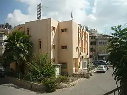 Reineh local council building | |
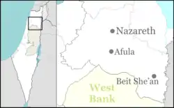  Reineh Location within Israel  Reineh Reineh (Israel) | |
| Coordinates: 32°43′20″N 35°18′55″E | |
| Grid position | 179/236 PAL |
| District | Northern |
| Area | |
| • Total | 10,902 dunams (10.902 km2 or 4.209 sq mi) |
| Population (2019)[1] | |
| • Total | 19,001 |
| • Density | 1,700/km2 (4,500/sq mi) |
History
Archaeological remains dating from the Middle Bronze Age,[4] Persian period (fifth–fourth centuries BCE),[2] Hellenistic (second century BCE),[2] early (first century BCE) and Middle (second century CE) Roman era[2][4][5][6] Byzantine,[4][6] early Islamic period,[5][6] Crusader[6] and Mamluk[6][7] have been found here. Pottery imported from Syria and Italy in the 13th-14th century CE found here, indicate that the village had a strong economy in the Mamluk era.[7]
Ottoman era
In 1517, the village was included in the Ottoman empire with the rest of Palestine, and in the 1596 tax-records it appeared as Rayna, located in the Nahiya of Tabariyya of the Liwa Safad. The taxable population was 151; 139 families and 6 bachelors; all Muslim, in addition to 6 Christian families. They paid taxes for various agricultural products; 5200 akçe on wheat, 2100 on barley, 350 on fruit trees, 200 on vegetable and fruit gardens, 250 on goats and beehives, in addition to 900 for occasional revenues and 480 for Jizya.[8][9] Archaeological remains from the early Ottoman era have also been found here.[7] A map from Napoleon's invasion of 1799 by Pierre Jacotin showed the place, named as El Raineh.[10]
In 1837, Reineh was badly damaged in the Galilee earthquake. William McClure Thomson travelled in the region three weeks afterwards, and described how Reineh, (which he called Rumaish), was mostly destroyed, with thirty deaths occurring as people were crushed in their homes. Many more would have suffered the same had they not been at evening prayers at the church there, which was a small building that was not seriously damaged.[11][12] In 1838; the population of Reineh was decribed as being Greek Orthodox Christians and Sunni Muslim.[13]
In 1875 Victor Guérin noted: "On 22 June, after a day resting up at Nazareth, I set out on my routemarch again at 5 am, heading northeast, then north northeast. At 5.33 am, I passed by a copious spring, called A'in er Reineh. Next to the small pool that catches its flow, an ancient sarcophagus has been placed, in the form of a trough, the external parts of which tank are elegantly sculptured with whorls and garlands. This spring waters gardens planted with fig and pomegranate trees. The village of Reineh stretches over the southern slopes of the hill it abuts. It contains approximately 800 residents, half of them Muslims and the other half schismatic Greeks, with some Protestants as well. The reason for the latter is that an English mission has been active here for some years and established a local school."[14]
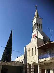
In 1881, the PEF's Survey of Western Palestine (SWP) described it: "A large village of well-built houses, containing about 500 Christians and Moslems. There are two springs south of the village; one, called 'Ain Kana. It is surrounded by arable ground and olive-groves. There is a church in the village."[15]
A population list from about 1887 showed that Reineh had about 1150 inhabitants; half Muslims and half Christians.[16]
British Mandatory period
In the Mandatory Palestine, at the 1922 census of Palestine, Reineh had a population of 787; 423 Christians and 364 Muslims.[17] Among the Christians, 203 were Greek Orthodox, 87 Roman Catholics, 101 Greek Catholic (Melkites) and 32 Church of England.[18] The population increased in the 1931 census to 1,015 residents living in 243 houses. The religious breakdown of the population was 389 Christians, 1 Jew and 625 Muslims.[19]
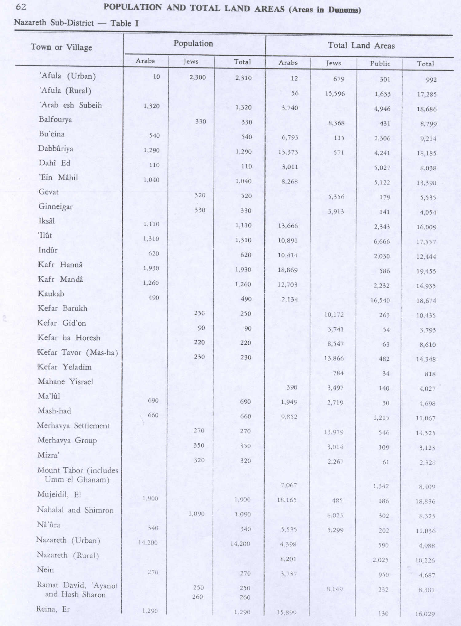
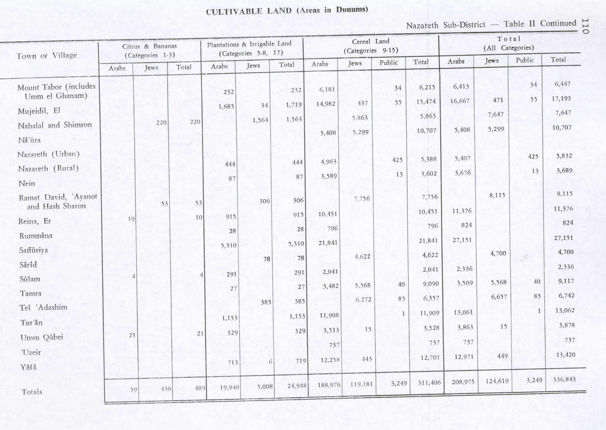
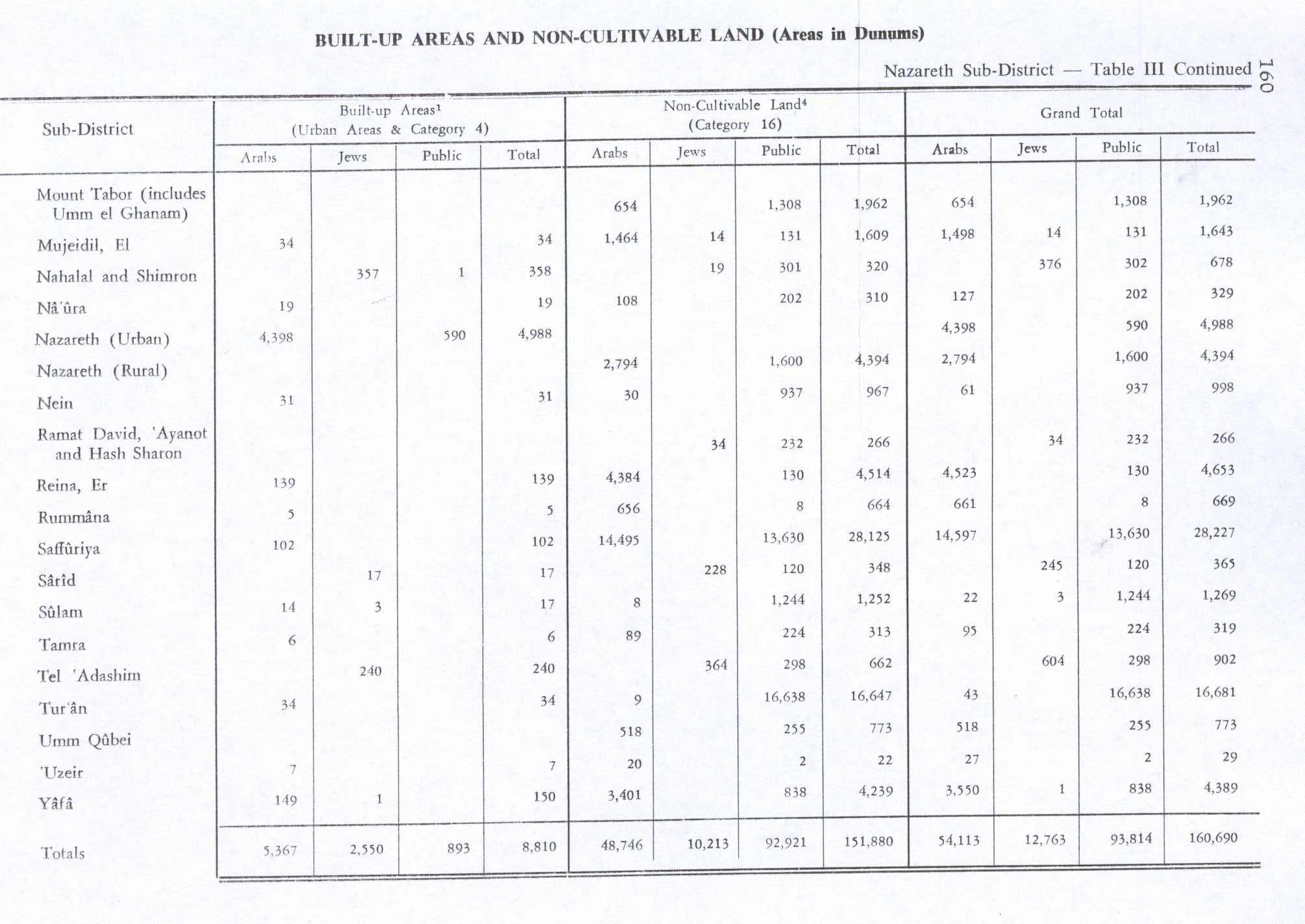
In the 1945 statistics Reineh (=Er Reina) had a population of 1,290; 500 Christians and 790 Muslims.[20] The total land area was 16,029 dunams; 15,899 owned by Arabs and the rest, 130 dunams, were public land.[21] Of this, 915 were allocated for plantations and irrigable land, 10,451 for cereals, 10 for citrus and bananas,[22] while 139 dunams were classified as built-up (urban) areas.[23]
1948-1949
.jpg.webp)
Reineh was conquered by Israeli forces in July 1948, during Operation Dekel.[25] In September, 14 Arab residents were reportedly murdered by Israeli authorities after they had been detained near the village, brought into Reineh and accused of smuggling. The victims included a young Bedouin woman, and Yusuf al-Turki, a member of the Land of Israel Workers Alliance.[26]
In December 1948/January 1948 is was proposed that Saffuriya's remaining inhabitants were moved to Reineh, as their "neighbouring [Jewish] settlements coveted Saffuriya lands".[27] When the Saffuriya inhabitans were expelled by the Israelis in January 1949, 14 were expelled to Lebanon, while the rest went to Nazareth, 'Illut, Kafr Kanna and Reineh.[28]
Cana
In 1878 Claude Reignier Conder suggested that the small spring south of Reineh, named "Ain Kana", was the the location of biblical Cana.[24][29]
See also
- People from Reineh
- Arab localities in Israel
References
- "Population in the Localities 2019" (XLS). Israel Central Bureau of Statistics. Retrieved 16 August 2020.
- Mokary, 2017, Er-Reina
- Israel populations: Reine
- Zidan, 2016, Er-Reina (North), Highway 79
- Jaffe, 2012, Er-Reina
- Kapul, 2018, Er-Reina
- Bisharat, 2017, Er-Reina
- Hütteroth and Abdulfattah, 1977, p. 188. Note that they have a typo; they write a total of 9000 Akçe, while the correct sum is 9480
- Note that Rhode, 1979, p. 6 writes that the register that Hütteroth and Abdulfattah studied from the Safad-district was not from 1595/6, but from 1548/9
- Karmon, 1960, p. 167
- Thomson, 1859, p. 429
- Robinson and Smith, 1841, vol 3, p. 209
- Robinson and Smith, 1841, vol 3 2nd appendix, p. 132
- Guérin, 1880, p. 165"Le 22 juin, après un jour de repos passé à Nazareth, je me remets en marche à cinq heures du matin, dans la direction du nord-est, puis du nord-nord-est. A cinq heures trente-trois minutes, je passe à côté d'une source abondante, appelée A'ïn er-Reineh. Près du petit bassin qui la recueille a été placé, en guise d'auge, un sarcophage antique, dont la cuve est ornée extérieurement de disques et de guirlandes de fleurs assez élégamment sculptés. Cette source arrose des jardins plantés de figuiers et de grenadiers. Le village de Reineh s'étend sur les pentes méridionales d'une colline à laquelle il est adossé. Il renferme environ huit cents habitants, moitié Musulmans et moitié Grecs schismatiques. Il faut joindre à ceux-ci quelques protestants. Une mission anglaise s'est, en effet, établie en cet endroit depuis plusieurs années, et y a fondé une école."
- Conder and Kitchener, 1881, SWP I, p. 363
- Schumacher, 1888, p. 182
- Barron, 1923, Table XI, Sub-district of Nazareth, p. 38
- Barron 1923, Table XVI, p. 51
- Mills 1932, p. 75
- Government of Palestine, Department of Statistics, 1945, p. 8
- Government of Palestine, Department of Statistics. Village Statistics, April, 1945. Quoted in Hadawi, 1970, p. 62
- Government of Palestine, Department of Statistics. Village Statistics, April, 1945. Quoted in Hadawi, 1970, p. 110
- Government of Palestine, Department of Statistics. Village Statistics, April, 1945. Quoted in Hadawi, 1970, p. 60
- Conder, 1878, p. 154
- Morris, 2004, p. 421
- Adam Raz, Classified docs reveal massacres of Palestinians in '48 – and what Israeli leaders knew Haaretz 9 December 2021
- Morris, 2004, p.516 note 84, p. 541; p. 517
- Morris, 2004, p. 517
- Conder and Kitchener, 1881, SWP I, p. 374: "'Ain Kana: A of good supply perennial water, flowing in a stream in the valley. The spring is surrounded with masonry, and near it is a masonry tank."
Bibliography
- Barron, J. B., ed. (1923). Palestine: Report and General Abstracts of the Census of 1922. Government of Palestine.
- Bisharat, Eyad (2017-10-03). "Er-Reina" (129). Hadashot Arkheologiyot – Excavations and Surveys in Israel. Cite journal requires
|journal=(help) - Conder, C.R. (1878). Tent Work in Palestine: A Record of Discovery and Adventure. I. R. Bentley & Son.
- Conder, C.R.; Kitchener, H. H. (1881). The Survey of Western Palestine: Memoirs of the Topography, Orography, Hydrography, and Archaeology. 1. London: Committee of the Palestine Exploration Fund.
- Dauphin, Claudine (1998). La Palestine byzantine, Peuplement et Populations. BAR International Series 726 (in French). III : Catalogue. Oxford: Archeopress. ISBN 0-860549-05-4. (p. 683)
- Department of Statistics (1945). Village Statistics, April, 1945. Government of Palestine.
- Guérin, V. (1880). Description Géographique Historique et Archéologique de la Palestine (in French). 3: Galilee, pt. 1. Paris: L'Imprimerie Nationale.
- Hadawi, S. (1970). Village Statistics of 1945: A Classification of Land and Area ownership in Palestine. Palestine Liberation Organization Research Center.
- Hütteroth, Wolf-Dieter; Abdulfattah, Kamal (1977). Historical Geography of Palestine, Transjordan and Southern Syria in the Late 16th Century. Erlanger Geographische Arbeiten, Sonderband 5. Erlangen, Germany: Vorstand der Fränkischen Geographischen Gesellschaft. ISBN 3-920405-41-2.
- Jaffe, Gilad Bezal’el (2012-12-31). "Er-Reina Final Report" (124). Hadashot Arkheologiyot – Excavations and Surveys in Israel. Cite journal requires
|journal=(help) - Kapul, Reuven (2018-02-26). "Er-Reina" (129). Hadashot Arkheologiyot – Excavations and Surveys in Israel. Cite journal requires
|journal=(help) - Karmon, Y. (1960). "An Analysis of Jacotin's Map of Palestine" (PDF). Israel Exploration Journal. 10 (3, 4): 155–173, 244–253.
- Mills, E., ed. (1932). Census of Palestine 1931. Population of Villages, Towns and Administrative Areas. Jerusalem: Government of Palestine.
- Mokary, Abdalla (2012-09-19). "Er-Reina Final Report" (124). Hadashot Arkheologiyot – Excavations and Surveys in Israel. Cite journal requires
|journal=(help) - Morris, B. (2004). The Birth of the Palestinian Refugee Problem Revisited. Cambridge University Press. ISBN 978-0-521-00967-6.
- Neubauer, A. (1868). La géographie du Talmud : mémoire couronné par l'Académie des inscriptions et belles-lettres (in French). Paris: Lévy. (p. 277)
- Palmer, E. H. (1881). The Survey of Western Palestine: Arabic and English Name Lists Collected During the Survey by Lieutenants Conder and Kitchener, R. E. Transliterated and Explained by E.H. Palmer. Committee of the Palestine Exploration Fund. (p. 132)
- Robinson, E.; Smith, E. (1841). Biblical Researches in Palestine, Mount Sinai and Arabia Petraea: A Journal of Travels in the year 1838. 3. Boston: Crocker & Brewster.
- Schumacher, G. (1888). "Population list of the Liwa of Akka". Quarterly statement - Palestine Exploration Fund. 20: 169–191.
- Thomson, W.M. (1859). The Land and the Book: Or, Biblical Illustrations Drawn from the Manners and Customs, the Scenes and Scenery, of the Holy Land. 1 (1 ed.). New York: Harper & brothers. (p. 439)
- Zidan, Omar (2016-12-29). "Er-Reina (North), Highway 79" (128). Hadashot Arkheologiyot – Excavations and Surveys in Israel. Cite journal requires
|journal=(help)
External links
- Information on Reina on Palestinian web site
- Survey of Western Palestine, Map 6: IAA, Wikimedia commons
.svg.png.webp)


Authority control  |
|---|