San Martín de Hidalgo Municipality, Jalisco
San Martín de Hidalgo Municipality (Spanish: Municipio de San Martín de Hidalgo) is a municipality located in the Región Valles of the state of Jalisco, Mexico.[1] As of 2010, the population was 26,306. The municipal seat is San Martín de Hidalgo. Other administrative communities include 5 delegations and 18 agencies.[1]
San Martín de Hidalgo Municipality
Municipio de San Martín de Hidalgo | |
|---|---|
 Coat of arms | |
| Motto(s): Piensa, progresa | |
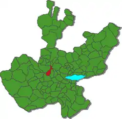 Location of the municipality in Jalisco | |
| Coordinates: 20°26′06″N 103°55′43″W | |
| Country |  Mexico Mexico |
| State |  Jalisco Jalisco |
| Region | Valles |
| Established | 1813 |
| Government | |
| • Municipal President | Moises Rodríguez Camacho ((Movimiento Ciudadano)) |
| Area | |
| • Municipality | 344.16 km2 (132.88 sq mi) |
| • Water | 5.39 km2 (2.08 sq mi) |
| • Urban | 2.72 km2 (1.05 sq mi) |
| Elevation | 1,305 m (4,281 ft) |
| Population (2020) | |
| • Municipality | 28,102 |
| • Density | 82/km2 (210/sq mi) |
| Demonym(s) | Sanmartínense |
| Time zone | UTC-6 (Central Standard Time) |
| • Summer (DST) | UTC-5 (Central Daylight Time) |
| Website | Official website |
Geography
The municipality is situated in the Valley of Ameca and the Sierra de Quila, of the Mexican state of Jalisco. In the 2010 census, its population totaled 24,127 inhabitants. The municipal seat is San Martín de Hidalgo, and its boroughs are El Crucero de Santa María, El Salitre, El Tepehuaje de Morelos, Buenavista de Cañedo, and Santa Cruz de las Flores. The municipality covers an area of 324.57 km². As of 2010, the municipality had a total population of 26,306.
Bordering the adjacent municipalities of Teuchitlán on the north, Ameca on the west, Tecolotlán on the south and Cocula on the east.
In territorial means, the municipality is divided into six regional subcommittees all chaired by the municipal seat, they are El Crucero de Santa María, El Salitre, El Tepehuaje de Morelos, Buenavista de Cañedo, and Santa Cruz de las Flores.[2] Each of these Municipal Delegations serve as the regional seats for other smaller communities called Municipal Agencies.
Communities and populations
| Name | 1900 census | 2000 census | 2005 census | 2010 census | 2020 census |
|---|---|---|---|---|---|
| San Martín de Hidalgo | 3,243 | 7,464 | 7,001 | 8,092 | 8,850 |
| El Crucero de Santa María | _ | 3,356 | 3,228 | 3,175 | 3,431 |
| El Salitre | 716 | 2,924 | 2,434 | 2,708 | 2,870 |
| El Tepehuaje de Morelos | 771 | 2,523 | 2,163 | 2,245 | 2,331 |
| Buenavista de Cañedo | 672 | 2,363 | 2,001 | 2,163 | 2,348 |
| Santa Cruz de las Flores | 698 | 1,931 | 1,397 | 1,531 | 1,367 |
| Trapiche de Abra | 157 | 1,235 | 1,115 | 1,280 | 1,379 |
| Labor de Medina | 295 | 882 | 863 | 863 | 910 |
| Los Guerrero | 238 | 801 | 674 | 724 | 741 |
| Ipazoltic | 676 | 531 | 510 | 533 | 566 |
| San Jerónimo (Los Barbosa) | 360 | 465 | 341 | 355 | 329 |
| San Isidro Palo Verde | 144 | 340 | 341 | 347 | 434 |
| Jesús María (El Zapote) | 468 | 301 | 278 | 319 | 340 |
| Lázaro Cárdenas | _ | 296 | 235 | 297 | 276 |
| Los Vergara | 131 | 303 | 269 | 281 | 334 |
| San Jacinto | 349 | 298 | 227 | 269 | 290 |
| Camajapita | 406 | _ | 280 | 238 | 228 |
| Venustiano Carranza | _ | _ | 93 | 199 | 154 |
| Santa Rosa del Jilguero | 84 | _ | 47 | 161 | 194 |
| Río Grande | _ | _ | 234 | 141 | 240 |
| San Jacintito (El Ranchito) | _ | _ | 119 | 122 | 129 |
| Lagunillas | 236 | _ | 94 | 106 | 82 |
| Mesa del Cobre | 209 | _ | 54 | 44 | 44 |
| El Cobre | 101 | _ | 36 | 36 | 51 |
References
- "Jalisco - San Martin Hidalgo". Enciclopedia de los Municipios y Delegaciones de México. Retrieved 13 March 2013.
- "Se Integra el COPLADEMUN". H. Ayuntamiento San Martín Hgo. Retrieved 7 May 2011.
External links
Localities of San Martín de Hidalgo Municipality, Jalisco, Mexico | ||
|---|---|---|
Municipal seat: San Martín de Hidalgo | ||
| Municipal delegations | 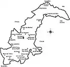 | |
| Municipal agencies | ||
| Other communities |
| |