Rural Municipality of Lac du Bonnet
Lac du Bonnet is a rural municipality in the province of Manitoba in western Canada, situated between the Nopiming Provincial Park to the northeast and Whiteshell Provincial Park to the southeast.
Lac Du Bonnet | |
|---|---|
Rural municipality | |
| Rural Municipality of Lac Du Bonnet | |
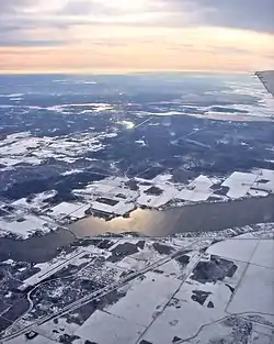 Aerial view of RM Lac du Bonnet | |
| Coordinates: 50.23833°N 96.07556°W | |
| Country | .svg.png.webp) Canada Canada |
| Province |  Manitoba Manitoba |
| Region | Eastman |
| Census division | No. 1 |
| Incorporated | 1917 |
| Government | |
| • Reeve | Loren Schinkel |
| Area | |
| • Land | 1,100.98 km2 (425.09 sq mi) |
| Population (2016) | |
| • Total | 3,121 |
| • Density | 2.8/km2 (7/sq mi) |
| Website | rmoflacdubonnet |
The separately-administered town of Lac du Bonnet lies within the borders of the municipality. It also mostly encircles the Pinawa local government district in the municipality's southeast part. A large portion of the municipality includes waters of the Winnipeg River and its tributaries.[1]
The RM contains the southern part of Manitoba's Brightstone Sand Hills Provincial Forest and the northern part of Agassiz Provincial Forest, although most of these forests lie in other RMs.
Demographics
In the 2011 Census, the Rural Municipality of Lac du Bonnet had a population of 2,930 living in 1,209 of its 2,569 total private dwellings.[2]
Communities
- Allegra
- Lee River
- McArthur Falls
- Milner Ridge
- Seddons Corner (part)
- Spring Well
References
- "History of the Rural Municipality of Lac du Bonnet". www.rmoflacdubonnet.com. Retrieved 2021-08-07.
- "Corrections and updates: Population and dwelling count amendments, 2011 Census". Statistics Canada. February 14, 2013. Retrieved February 16, 2013.
External links
 |
Wikimedia Commons has media related to Rural Municipality of Lac du Bonnet. |
Places adjacent to Rural Municipality of Lac du Bonnet | |
|---|---|


Division No. 1, Manitoba (Eastern Manitoba) | ||
|---|---|---|
| Towns |  | |
| Local government districts | ||
| Rural municipalities | ||
| First Nations | ||
| Indian reserves |
| |
| Unorganized areas | ||
| Unincorporated communities | ||