Taupō District
Taupō District is a territorial authority district in New Zealand. It covers 6,350 km² of land, and a further 610 km² of lake area, including Lake Taupō, New Zealand's largest lake, and Lake Rotoaira. The district stretches from the small town of Mangakino in the northwest to the Tongariro National Park in the south, and east into the Kaingaroa Forest. The district's population is largely located in the two main centres, Taupō and Tūrangi.
Taupō District | |
|---|---|
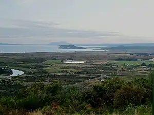 Eastern Lake Taupō, Tūrangi to Taupō | |
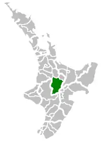 Location of Taupō District within New Zealand | |
| Country | New Zealand |
| Regions |
|
| Main towns and settlements | Taupō, Kinloch, Tūrangi, Mangakino |
| Government | |
| • Mayor | David Trewavas |
| • Parliamentary electorate | Taupō |
| • Territorial authority | Taupō District Council |
| Area | |
| • Total | 6,970 km2 (2,690 sq mi) |
| Population (June 2021)[1] | |
| • Total | 41,000 |
| • Density | 5.9/km2 (15/sq mi) |
| Time zone | UTC+12 (NZST) |
| • Summer (DST) | UTC+13 (NZDT) |
| Postcode(s) | |
| Area code(s) | 07 |
| Website | taupodc.govt.nz |
Local government
The district is governed by Taupō District Council. The vast majority of the district also falls within the jurisdiction of Waikato Regional Council.
History
Little is known about early Māori settlement near Taupō, although Ngāti Tūwharetoa have been the main iwi of the area for several hundred years. Major pā were situated at the southern end of the lake, to the west of the modern town of Tūrangi.
Taupo town was founded in 1869 as a garrison town during the New Zealand Wars, but remained small due to the poor volcanic soils of the region. It was not until the 1950s that the region started to develop, with forestry and the construction of the Wairakei geothermal power station.
Population
The Taupō District territorial authority has a population of 41,000 as of June 2021.[1] This comprises 26,000 people in the Taupō urban area, 3,790 people in the Tūrangi urban area, and 11,210 people in other settlements and in rural areas.
| Year | Pop. | ±% p.a. |
|---|---|---|
| 2006 | 32,418 | — |
| 2013 | 32,907 | +0.21% |
| 2018 | 37,203 | +2.48% |
| Source: [2] | ||
Taupō District had a population of 37,203 at the 2018 New Zealand census, an increase of 4,296 people (13.1%) since the 2013 census, and an increase of 4,785 people (14.8%) since the 2006 census. There were 13,830 households. There were 18,522 males and 18,681 females, giving a sex ratio of 0.99 males per female. Of the total population, 7,653 people (20.6%) were aged up to 15 years, 6,072 (16.3%) were 15 to 29, 16,404 (44.1%) were 30 to 64, and 7,077 (19.0%) were 65 or older.
Ethnicities were 76.4% European/Pākehā, 29.9% Māori, 3.2% Pacific peoples, 4.9% Asian, and 1.8% other ethnicities (totals add to more than 100% since people could identify with multiple ethnicities).
The percentage of people born overseas was 16.6, compared with 27.1% nationally.
Although some people objected to giving their religion, 51.9% had no religion, 32.9% were Christian, and 8.3% had other religions.
Of those at least 15 years old, 4,359 (14.8%) people had a bachelor or higher degree, and 5,760 (19.5%) people had no formal qualifications. The median income was $30,300. The employment status of those at least 15 was that 14,385 (48.7%) people were employed full-time, 4,854 (16.4%) were part-time, and 978 (3.3%) were unemployed.[2]

References
- "Population estimate tables - NZ.Stat". Statistics New Zealand. Retrieved 22 October 2021.
- "Statistical area 1 dataset for 2018 Census". Statistics New Zealand. March 2020. Taupo District (021). 2018 Census place summary: Taupo District