Tropical Storm Maliksi (2018)
Severe Tropical Storm Maliksi, known in the Philippines as Severe Tropical Storm Domeng, was a tropical cyclone in June 2018 that brought rainfall to the Philippines and Japan. It caused 2 deaths and prompted the PAGASA to declare the beginning of the rainy season in the Philippines. The fifth named storm and 4th tropical cyclone in the Philippine Area of Responsibility (PAR),[1] it was first noted as an area of convection on May 31.
| Severe tropical storm (JMA scale) | |
|---|---|
| Tropical storm (SSHWS) | |
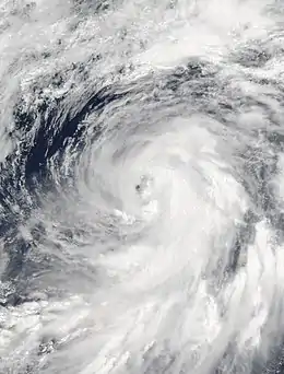 Severe Tropical Storm Maliksi at peak intensity on June 10 | |
| Formed | June 3, 2018 |
| Dissipated | June 13, 2018 |
| (Extratropical after June 11, 2018) | |
| Highest winds | 10-minute sustained: 110 km/h (70 mph) 1-minute sustained: 110 km/h (70 mph) |
| Lowest pressure | 970 hPa (mbar); 28.64 inHg |
| Fatalities | 2 total |
| Damage | None |
| Areas affected | Philippines, Japan |
| Part of the 2018 Pacific typhoon season | |
Meteorological history
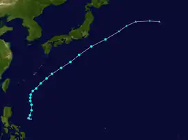
Tropical storm (39–73 mph, 63–118 km/h)
Category 1 (74–95 mph, 119–153 km/h)
Category 2 (96–110 mph, 154–177 km/h)
Category 3 (111–129 mph, 178–208 km/h)
Category 4 (130–156 mph, 209–251 km/h)
Category 5 (≥157 mph, ≥252 km/h)
Unknown


 Extratropical cyclone / Remnant low / Tropical disturbance / Monsoon depression
On May 31 at 06:00 UTC, the Joint Typhoon Warning Center (JTWC) began monitoring an area of convection approximately 95 nautical miles (175 km; 110 mi) south of Palau. The system was disorganized, with convection being located to the east of a broad and elongated low-level circulation. It was located in favorable conditions for development and sea surface temperatures in the area ranged from 29–30 °C (84–86 °F), though the JTWC assessed its development potential in the next day as low.[2] The system's low-level circulation began consolidating, and on June 2 at 00:30 UTC, the JTWC upgraded its development potential in the next day to medium.[3] On June 3 at 18:00 UTC, the Japan Meteorological Agency (JMA) assessed that a tropical depression had formed over the Philippine Sea.[4][lower-alpha 1] On the next day at 03:00 UTC, the PAGASA gave the depression the local name Domeng as it was located 675 kilometres (420 mi) east of Guiuan.[6] The depression absorbed an invest as convection covered the low-level circulation, and on 14:00 UTC the same day, the JTWC issued a Tropical Cyclone Formation Alert as it was located approximately 225 nautical miles (415 km; 260 mi) northwest of Palau.[7]
The depression began to exhibit signs of anticyclonic outflow as it was steered northward by a mid-level subtropical high-pressure area,[8] and on June 7 at 12:00 UTC, the JTWC upgraded the system to a tropical depression, assigning it the designation 06W.[9] 6 hours later at 18:00 UTC, both the JMA and the JTWC upgraded the depression to a tropical storm, with the JMA giving it the name Maliksi;[4][9] the system's circulation remained broad.[10] Maliksi passed by the western edge of the high-pressure area and turned northeast,[11] and on June 9 at 06:00 UTC, the JMA upgraded it to a severe tropical storm.[4] At 21:00 UTC, Maliksi exited the PAR, with the PAGASA issuing its final warning on the system.[12] On June 10 at 00:00 UTC, Maliksi peaked in intensity, with maximum sustained winds of 110 km/h (70 mph) and a minimum barometric pressure of 970 hPa (29 inHg) as it was located southeast of Okinawa.[4][lower-alpha 2] The JTWC assessed Maliksi to have peaked at the same time, also estimating the same windspeed in the 1-minute sustained standard.[9][lower-alpha 3] Maliksi began slowly accelerating to the northeast, developing a ragged eye as it became exposed to strong westerlies.[14] After reaching peak intensity, convection around the center began to decrease,[15] with the low-level circulation beginning to elongate.[16] Maliksi began extratropical transition as it was located over an unfavorable environment,[17] and on June 11 at 18:00 UTC, the JMA assessed that Maliksi completed its transition into an extratropical cyclone,[4] with its low-level circulation being displaced from its upper-level circulation;[18] the JTWC estimated extratropical transition began 6 hours earlier.[9] Maliksi's remnants dissipated east of Honshu on June 13.[4]
Preparations and impact
Philippines
Maliksi enhanced the southwest monsoon in the Philippines, bringing monsoonal rains over Luzon and Visayas. The PAGASA warned residents of possible floods and landslides, advising fishermen not to go to sea.[19] Classes in Cavite were suspended, with suspensions also occurring in parts of Rizal, Palawan, Occidental Mindoro, and Biliran.[20] A bridge received damage in San Fernando, Romblon, and on Tablas Island, power went out for a day due to fallen trees impacting power lines. Patients in the University of Santo Tomas Hospital were evacuated after floodwaters entered the building.[21] Trees were uprooted in Quezon City and Coron, Palawan, and in Calintaan, a temporary bridge was washed out by a river. A SkyJet Airlines flight en route from Metro Manila overshot the runway at Francisco B. Reyes Airport, injuring 2 out of 80 passengers. In Batangas, 8 municipalities lost power on June 9 at 3:00 PM local time, before being restored 6 hours later.[20] In Metro Manila, overnight rains flooded at least 43 barangays,[22] with several streets becoming impassable.[23] Floods in barangay Doña Imelda reached 5 feet (150 cm).[20] On June 9 at 11:00 PM local time, due to the heavy rainfall in Metro Manila, the PAGASA issued a red rainfall advisory for the area, along with other warnings for the regions of Calabarzon and Central Luzon.[24] Due to the effects of Maliksi, the PAGASA declared the beginning of the rainy season due to widespread rainfall in PAGASA weather stations.[25] A 27-year-old[20] from El Nido, Palawan drowned after falling from his jetski after it toppled, and a fisherman drowned after jumping into the water to fix the fishing net. 72 passengers and 2 vessels were stranded in Legazpi, Albay and Rapu-Rapu, with other ports in Oriental Mindoro suspending their operations.[22]
Japan
On the small island of Hachijō-jima, 287.5 millimetres (11.32 in) of precipitation was recorded, and on Kitadaitōjima, maximum winds were recorded at 23.2 metres per second (85 km/h; 50 mph).[26] In Chichibu, Saitama, there were rains around noon as the storm was approaching the Kantō Region, though winds were not strong.[27]
Notes
- The Japan Meteorological Agency is the official Regional Specialized Meteorological Center for the western Pacific Ocean.[5]
- All winds are in 10-minute sustained standards, as per the Japan Meteorological Agency,[4] unless otherwise stated.
- The Joint Typhoon Warning Center uses 1-minute sustained winds to measure wind speeds for tropical cyclones.[13]
References
- "LPA strengthens into Tropical Depression Domeng". Rappler. June 5, 2018. Retrieved April 12, 2021.
- "Significant Tropical Weather Advisory for the Western and South Pacific Oceans". tgftp.nws.noaa.gov. May 31, 2018. Archived from the original on May 31, 2018. Retrieved April 6, 2021.
- "Significant Tropical Weather Advisory for the Western and South Pacific Oceans". tgftp.nws.noaa.gov. June 2, 2018. Archived from the original on June 2, 2018. Retrieved April 7, 2021.
- Annual Report on the Activities of the RSMC Tokyo - Typhoon Center 2018 (PDF) (Report). Japan Meteorological Agency. 2019. Retrieved April 7, 2021.
- "Annual Report on Activities of the RSMC Tokyo – Typhoon Center 2000" (PDF). Japan Meteorological Agency. February 2001. p. 3. Archived (PDF) from the original on October 31, 2015. Retrieved April 8, 2021.
- "Severe Weather Bulletin #1 for Tropical Depression "Domeng"". pubfiles.pagasa.dost.gov.ph. June 5, 2018. Archived from the original (PDF) on June 5, 2018. Retrieved April 7, 2021.
- "Tropical Cyclone Formation Alert". metoc.navy.mil. June 5, 2018. Archived from the original on June 6, 2018. Retrieved April 7, 2021.
- "RSMC Tropical Cyclone Prognostic Reasoning no. 6 for TD Located at 17.0N 127.9E". wis-jma.go.jp. June 7, 2018. Archived from the original on June 9, 2018. Retrieved April 7, 2021.
- "2018 Western North Pacific Best Track Data". Joint Typhoon Warning Center. Retrieved September 13, 2021.
- "Prognostic Reasoning for Tropical Storm 06W (Maliksi) Warning NR 01". tgftp.nws.noaa.gov. June 8, 2018. Archived from the original on June 8, 2018. Retrieved April 8, 2021.
- "Prognostic Reasoning for Tropical Storm 06W (Maliksi) Warning NR 05". tgftp.nws.noaa.gov. June 9, 2018. Archived from the original on June 9, 2018. Retrieved April 8, 2021.
- "TTT Storm Warning 21 (Final)". tgftp.nws.noaa.gov. June 9, 2021. Archived from the original on June 10, 2018. Retrieved April 8, 2021.
- "Frequently Asked Questions". Joint Typhoon Warning Center. Retrieved September 13, 2021.
- "Prognostic Reasoning for Tropical Storm 06W (Maliksi) Warning NR 09". tgftp.nws.noaa.gov. June 10, 2018. Archived from the original on June 10, 2018. Retrieved April 8, 2021.
- "Prognostic Reasoning for Tropical Storm 06W (Maliksi) Warning NR 11". tgftp.nws.noaa.gov. June 10, 2018. Archived from the original on June 10, 2018. Retrieved April 8, 2021.
- "Prognostic Reasoning for Tropical Storm 06W (Maliksi) Warning NR 14". tgftp.nws.noaa.gov. June 11, 2018. Archived from the original on June 11, 2018. Retrieved April 8, 2021.
- "RSMC Tropical Cyclone Prognostic Reasoning no. 22 for STS 1805 Maliksi (1805)". tgftp.nws.noaa.gov. June 11, 2018. Archived from the original on June 11, 2018. Retrieved April 8, 2021.
- "NASA finds Tropical Storm Maliksi weakening, expanding". Phys.org. June 11, 2018. Retrieved April 9, 2021.
- "Bagyong 'Domeng' magpapa-ulan hanggang Linggo". ABS-CBN (in Tagalog). June 6, 2018. Retrieved April 8, 2021.
- NDRRMC Update SitRep No. 06 re Preparedness Measures and Effects of Tropical Depression (TD) "Domeng" for the period of 8:00 PM, 09 June 2018 - 8:00 AM, 10 June 2018 (PDF) (Report). National Disaster Risk Reduction and Management Council. June 10, 2018. Retrieved April 12, 2021.
- "Monsoon rains enhanced by Domeng damage bridge, cause floods". GMA News and Public Affairs. June 10, 2018. Retrieved April 8, 2021.
- "2 dead in aftermath of Typhoon Domeng". CNN Philippines. June 10, 2018. Archived from the original on 2018-06-12. Retrieved April 7, 2021.
- "Overnight rains due to habagat enhanced by Domeng flood parts of Metro Manila". GMA News and Public Affairs. June 10, 2018. Retrieved April 8, 2021.
- "Domeng on its way out, but still enhancing monsoon". Rappler. June 9, 2018. Retrieved April 9, 2021.
- "PAGASA: Rainy season begins in the Philippines". Rappler. June 8, 2018. Retrieved April 7, 2021.
- "Digital Typhoon: Typhoon 201805 (MALIKSI) - Disaster Information". agora.ex.nii.ac.jp. Retrieved April 9, 2021.
- "2018年6月11日 台風5号にご注意ください". city.chichibu.lg.jp (in Japanese). June 11, 2018. Retrieved April 9, 2021.
External links
- JMA Best Track Data (in Japanese)
- 06W.MALIKSI from the U.S. Naval Research Laboratory
 |
Wikimedia Commons has media related to Tropical Storm Maliksi (2018). |
Tropical cyclones of the 2018 Pacific typhoon season | ||||||||||||||||||||||||||||||||||||||||||||||||||||||||||||||||||||||||||||||||||||||||||||
|---|---|---|---|---|---|---|---|---|---|---|---|---|---|---|---|---|---|---|---|---|---|---|---|---|---|---|---|---|---|---|---|---|---|---|---|---|---|---|---|---|---|---|---|---|---|---|---|---|---|---|---|---|---|---|---|---|---|---|---|---|---|---|---|---|---|---|---|---|---|---|---|---|---|---|---|---|---|---|---|---|---|---|---|---|---|---|---|---|---|---|---|---|
 |
| |||||||||||||||||||||||||||||||||||||||||||||||||||||||||||||||||||||||||||||||||||||||||||
| ||||||||||||||||||||||||||||||||||||||||||||||||||||||||||||||||||||||||||||||||||||||||||||

