Unorganized South Nipissing District
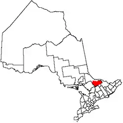
Unorganized South Nipissing District is an unorganized area in north-central Ontario, in the District of Nipissing. It is almost entirely within and includes most of Algonquin Provincial Park.
Unorganized South Nipissing District | |
|---|---|
| Nipissing, Unorganized, South Part | |
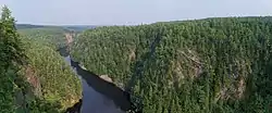 The Barron Canyon in Algonquin Park | |
 | |
| Coordinates: 45°50′N 78°25′W | |
| Country | Canada |
| Province | Ontario |
| District | Nipissing |
| Government | |
| • Federal riding | Nipissing—Timiskaming |
| • Prov. riding | Nipissing, Renfrew—Nipissing—Pembroke |
| Area | |
| • Land | 6,710.22 km2 (2,590.83 sq mi) |
| Population (2016)[1] | |
| • Total | 103 |
| • Density | 0.015/km2 (0.04/sq mi) |
| Time zone | UTC-5 (EST) |
| • Summer (DST) | UTC-4 (EDT) |
| Area code(s) | 705 |
Localities
Localities located within the unorganized area are:
Communities
Townships
The following geographic townships are included:
- Anglin
- Ballantyne
- Barron
- Biggar
- Bishop
- Boulter
- Bower
- Boyd
- Bronson
- Butt
- Canisbay
- Clancy
- Deacon
- Devine
- Dickson
- Edgar
- Finlayson
- Fitzgerald
- Freswick
- Guthrie
- Hunter
- Lauder
- Lister
- Master
- McCraney
- McLaughlin
- Niven
- Osler
- Paxton
- Peck
- Pentland
- Preston
- Sproule
- Stratton
- White
- Wilkes
All, except Boulter, Lauder, and parts of Ballantyne, Boyd and Paxton are within Algonquin Provincial Park.
Demographics
| Canada census – Nipissing, Unorganized, South Part community profile | |||
|---|---|---|---|
| 2016 | 2011 | 2006 | |
| Population: | 103 (28.8% from 2011) | 80 (% from 2006) | 67 (19.6% from 2001) |
| Land area: | 6,710.22 km2 (2,590.83 sq mi) | 6,710.88 km2 (2,591.09 sq mi) | 6,704.78 km2 (2,588.73 sq mi) |
| Population density: | 0.0/km2 (0/sq mi) | 0.0/km2 (0/sq mi) | 0.0/km2 (0/sq mi) |
| Median age: | 51.5 (M: 41.8, F: 58.5) | 52.0 (M: 50.5, F: 53.0) | |
| Total private dwellings: | 273 | 138 | 99 |
| Median household income: | $55,040 | ||
| References: 2016[2] 2011[3] 2006[4] earlier[5] | |||
|
| |||||||||||||||||||||||||||||||||
| Population counts are not adjusted for boundary changes. Source: Statistics Canada | ||||||||||||||||||||||||||||||||||
Population distribution
Most of the population lives outside of Algonquin Park on the northern or northwestern fringes of the region. According to the 2016 Census, the blocks that encompass the Townships of Boulter, Lauder, Pentland and Boyd had a combined population of 57. The area around Loxton Lake in Ballantyne Township (Census Block 35480228012) had a population of 26. Census Block 35480228215 which covers parts of Bronson and Stratton Townships in the Northeast corner of Algonquin Park had a population of 5, while 15 people lived in Census Block 35480228146 which covers most of the western part of the region.
See also
References
- "Nipissing, Unorganized, South Part census profile". 2016 Census of Population. Statistics Canada. Retrieved 2019-01-12.
- "2016 Community Profiles". 2016 Canadian Census. Statistics Canada. February 21, 2017. Retrieved 2021-11-24.
- "2011 Community Profiles". 2011 Canadian Census. Statistics Canada. July 5, 2013. Retrieved 2012-02-10.
- "2006 Community Profiles". 2006 Canadian Census. Statistics Canada. March 30, 2011. Retrieved 2012-02-10.
- "2001 Community Profiles". 2001 Canadian Census. Statistics Canada. February 17, 2012.
External links
 Media related to Unorganized Nipissing, South Part at Wikimedia Commons
Places adjacent to Unorganized South Nipissing District | |
|---|---|


| Cities |  | |
|---|---|---|
| Towns | ||
| Townships | ||
| First Nations | ||
| Indian reserves | ||
| Unorganized areas | ||
| Local services boards | ||
| ||