Waitangi, Chatham Islands
Waitangi is the main port and settlement on the Chatham Islands. It is located on the southern shore of Petre Bay, on the west coast of the main island. This community is by far the largest settlement in the archipelago, with a population of 177 in the 2018 census, about 27% of the group's population of 663.
Waitangi | |
|---|---|
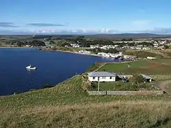 Town of Waitangi on Chatham Island in May 2008. | |
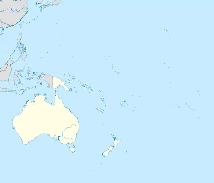  Waitangi | |
| Coordinates: 43°57′05″S 176°33′40″W | |
| Country |  New Zealand New Zealand |
| Territorial authority | Chatham Islands |
| Area | |
| • Total | 4.86 km2 (1.88 sq mi) |
| Population (2018 Census)[2] | |
| • Total | 177 |
| • Density | 36/km2 (94/sq mi) |
| Time zone | Chatham Standard Time Zone |
Waitangi is the seat of Chatham Islands Council, hosts a visiting District Court Judge, and is the base of a local police constable. A doctor and two nurses staff a four-bedroom hospital facility. Te One School and Kaingaroa School are based near the settlement.
Local services in Waitangi include Port Waitangi and Fish Processing Factory, an ANZ Bank and Post Office, liquor store, general store, burger cafe, and a hotel and pub. Local volunteers run radio station Radio Weka and rebroadcast New Zealand television. Broadband and 4G mobile phone coverage are avaliable through Spark, 2degress and Vodafone; through a RCG network, as well as satellite and ADSL broadband services.
The town also includes Kopinga, the meeting ground of Moriori, which features the Hokomenetai meeting house.[3][4]
Demographics
Waitangi is described as a rural settlement by Statistics New Zealand, and covers 4.86 km2 (1.88 sq mi).[1]
| Year | Pop. | ±% p.a. |
|---|---|---|
| 2006 | 189 | — |
| 2013 | 168 | −1.67% |
| 2018 | 177 | +1.05% |
| Source: [2] | ||
Waitangi had a population of 177 at the 2018 New Zealand census, an increase of 9 people (5.4%) since the 2013 census, and a decrease of 12 people (-6.3%) since the 2006 census. There were 72 households. There were 81 males and 96 females, giving a sex ratio of 0.84 males per female. The median age was 43.7 years (compared with 37.4 years nationally), with 24 people (13.6%) aged under 15 years, 30 (16.9%) aged 15 to 29, 99 (55.9%) aged 30 to 64, and 21 (11.9%) aged 65 or older.
Ethnicities were 78.0% European/Pākehā, 66.1% Māori, 3.4% Pacific peoples, and 1.7% Asian (totals add to more than 100% since people could identify with multiple ethnicities).
Although some people objected to giving their religion, 47.5% had no religion, 37.3% were Christian and 3.4% had other religions.
Of those at least 15 years old, 15 (9.8%) people had a bachelor or higher degree, and 39 (25.5%) people had no formal qualifications. The median income was $36,100, compared with $31,800 nationally. The employment status of those at least 15 was that 90 (58.8%) people were employed full-time, 30 (19.6%) were part-time, and 0 (0.0%) were unemployed.[2]
Climate
Waitangi experiences an oceanic climate with mild winters and warm summers. Precipitation can fall at any time throughout the year, with the highest percent of rain being centered during the winter.
| Climate data for Waitangi, Chatham Islands | |||||||||||||
|---|---|---|---|---|---|---|---|---|---|---|---|---|---|
| Month | Jan | Feb | Mar | Apr | May | Jun | Jul | Aug | Sep | Oct | Nov | Dec | Year |
| Average high °C (°F) | 17.8 (64.0) |
18.1 (64.6) |
17.3 (63.1) |
15.4 (59.7) |
13.4 (56.1) |
11.5 (52.7) |
10.9 (51.6) |
11.4 (52.5) |
12.3 (54.1) |
13.2 (55.8) |
14.6 (58.3) |
16.5 (61.7) |
14.4 (57.9) |
| Daily mean °C (°F) | 14.8 (58.6) |
15.1 (59.2) |
14.4 (57.9) |
12.5 (54.5) |
10.5 (50.9) |
8.8 (47.8) |
8.0 (46.4) |
8.6 (47.5) |
9.5 (49.1) |
10.6 (51.1) |
11.9 (53.4) |
13.7 (56.7) |
11.5 (52.8) |
| Average low °C (°F) | 11.9 (53.4) |
12.2 (54.0) |
11.5 (52.7) |
9.7 (49.5) |
7.6 (45.7) |
6.2 (43.2) |
5.2 (41.4) |
5.8 (42.4) |
6.7 (44.1) |
8.0 (46.4) |
9.3 (48.7) |
11.0 (51.8) |
8.8 (47.8) |
| Average precipitation mm (inches) | 52 (2.0) |
56 (2.2) |
85 (3.3) |
74 (2.9) |
90 (3.5) |
93 (3.7) |
109 (4.3) |
79 (3.1) |
68 (2.7) |
56 (2.2) |
53 (2.1) |
71 (2.8) |
886 (34.9) |
| Source: http://en.climate-data.org/location/475472/ | |||||||||||||
References
- "ArcGIS Web Application". statsnz.maps.arcgis.com. Retrieved 26 November 2021.
- "Statistical area 1 dataset for 2018 Census". Statistics New Zealand. March 2020. 7027635 (7027635). 2018 Census place summary: 7027635
- "Te Kāhui Māngai directory". tkm.govt.nz. Te Puni Kōkiri.
- "Māori Maps". maorimaps.com. Te Potiki National Trust.
- "From city life to the Chathams Islands: Why Helen Bint chose a life of isolation in remote New Zealand". thisNZlife. 10 May 2019. Retrieved 12 September 2021.
External links
- chathams.co.nz
- Chatham Islands (last updated 1998)
- Photographs of Waitangi 1907, c1920
| Islands (by English name) |
|  |
|---|---|---|
| Islands (by Māori/Moriori name) |
| |
| Coastal landforms | ||
| Populated places | ||
| Other geographic features | ||
| Historical events | ||