Wattleup, Western Australia
Wattleup is a southern suburb of Perth, Western Australia, located within the City of Cockburn. Since 2001, it has been part of the Hope Valley-Wattleup Redevelopment Project,[3] which has meant the demolition of most of the houses in the area for future industry. Wattleup had many market gardens in the past. They provided agricultural produce for the town of Fremantle.
| Wattleup Perth, Western Australia | |||||||||||||||
|---|---|---|---|---|---|---|---|---|---|---|---|---|---|---|---|
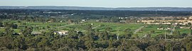 The view of the rural suburb of Wattleup in 2011 | |||||||||||||||
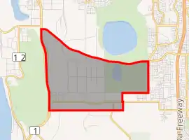
| |||||||||||||||
| Coordinates | 32.170°S 115.824°E | ||||||||||||||
| Population | 461 (2016 census)[1] | ||||||||||||||
| • Density | 40.44/km2 (104.7/sq mi) | ||||||||||||||
| Postcode(s) | 6166 | ||||||||||||||
| Area | 11.4 km2 (4.4 sq mi)[2] | ||||||||||||||
| LGA(s) | City of Cockburn | ||||||||||||||
| State electorate(s) | Cockburn | ||||||||||||||
| Federal division(s) | Fremantle | ||||||||||||||
| |||||||||||||||
The suburb's name originates from Wattleup Road which dates back to 1931. The name of Wattleup was approved for the suburb in May 1962.[4]
References
- Australian Bureau of Statistics (27 June 2017). "Wattleup (State Suburb)". 2016 Census QuickStats. Retrieved 3 December 2021.

- Australian Bureau of Statistics (27 June 2017). "2016 Community Profiles: Wattleup (State Suburb)". 2016 Census of Population and Housing. Retrieved 3 December 2021.
- http://www.epa.wa.gov.au/hope-valley-wattleup-redevelopment-project-master-plan Government of Western Australia Environmental Protection Agency, Hope Valley-Wattleup Redevelopment Project Master Plan. Retrieved 12 August 2018
- Western Australian Land Information Authority. "History of metropolitan suburb names – W". Retrieved 3 December 2021.
This article is issued from Wikipedia. The text is licensed under Creative Commons - Attribution - Sharealike. Additional terms may apply for the media files.