Whitworth, Quebec
Whitworth is an Indian reserve listed by the Canadian Geographical Names Database[1] it is not listed by Indigenous and Northern Affairs Canada[5] or the last two Canadian census.[4][6] It is located in the Bas-Saint-Laurent region of Quebec, geographically located within the territory of Rivière-du-Loup Regional County Municipality but is not legally part of it. Its population was 0 in the 2006 Canadian census and does not appear in either the 2011 or 2016 Canadian Census.[2][4][6][7]
Whitworth | |
|---|---|
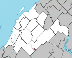 Location within Rivière-du-Loup RCM. | |
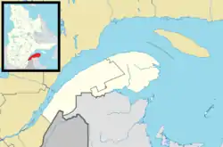  Whitworth Location in eastern Quebec. | |
| Coordinates: 47°42′06″N 69°16′19″W[1][2] | |
| Country | Canada |
| Province | Quebec |
| Region | Bas-Saint-Laurent |
| RCM | None |
| Constituted | unspecified |
| Government | |
| • Federal riding | Montmagny—L'Islet—Kamouraska—Rivière-du-Loup |
| • Prov. riding | Rivière-du-Loup–Témiscouata |
| Area | |
| • Total | 1.60 km2 (0.62 sq mi) |
| Time zone | UTC−05:00 (EST) |
| • Summer (DST) | UTC−04:00 (EDT) |
See also
References
- "Whitworth 21". Geographical Names Data Base. Natural Resources Canada. Retrieved 18 August 2021.
- Reference number 82096 of the Commission de toponymie du Québec (in French)
- Geographic code 12802 in the official Répertoire des municipalités (in French)
- "(Code 2412802) Census Profile". 2011 census. Statistics Canada. 2012.
- Search by Reserve/Settlement/Village
- "Population and dwelling counts, for Canada, provinces and territories, and census subdivisions (municipalities), 2016 and 2011 censuses – 100% data, Quebec". February 7, 2018. Retrieved August 18, 2021.
- "(Code 2412802) Community Profiles". 2006 census. Statistics Canada. 2007.
External links
- Native nations communities of Québec (Secrétariat aux affaires autochtones du Québec)
| Cities & Towns | |
|---|---|
| Municipalities | |
| Parishes | |
| |

Authority control  |
|---|
This article is issued from Wikipedia. The text is licensed under Creative Commons - Attribution - Sharealike. Additional terms may apply for the media files.