Calinaoan Centro
Calinaoan Centro[1] is the first barangay out of the 27 barangays of the Municipality of Santo Tomas, province of Isabela[2] in the Philippines. It is located in the opening part of Santo Tomas, after the town of Delfin Albano.[3] According to the 2021 barangay profile, it has a population of 935 people.[4] [5]
Calinaoan Centro | |
|---|---|
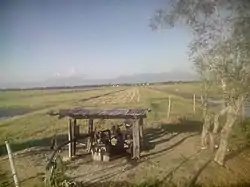 Calinaoan Centro rice fields | |
| Nickname(s): Centro | |
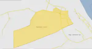 Map of Calinaoan Centro | |
.svg.png.webp)  Calinaoan Centro Location within the Philippines | |
| Coordinates: 17°20′45″N 121°45′13″E | |
| Country | Philippines |
| Region | Cagayan Valley (Region II) |
| Province | Isabela |
| District | 1st District of Isabela |
| Municipality | Santo Tomas (Sto. Tomas) |
| Puroks | 6 |
| Government | |
| • Chairman | Joey M. Mamauag |
| Area | |
| • Total | 0.79 km2 (0.31 sq mi) |
| Population (2021) | |
| • Total | 935 |
| Time zone | UTC+8 (PST) |
| ZIP code | 3327 |
| Income class | 4th Class, Rural |
| Largest Source of Income | Agriculture |
Education
Calinaoan Centro[1] has one public school,[6] the Calinaoan Elementary School, and one private secondary school, which is Northern Isabela Academy, the first and only private secondary institution in the town of Santo Tomas.
Almost all the young population of the barangay goes to either elementary or high school except for the 1% that cannot afford to go to high school.
This coming school year 2016–2017, the high school Northern Isabela Academy in the said barangay would be implementing Grade 11 to outcoming Grade 10 students.
Livelihood

The primary source of income of the barangay is agriculture, primarily with farming. Most of its lands is used for rice and corn plantations. The locals also raise livestock to produce commodities such as food and money.[6]
Climate
| Climate data for Calinaoan Centro, Santo Tomas, Isabela | |||||||||||||
|---|---|---|---|---|---|---|---|---|---|---|---|---|---|
| Month | Jan | Feb | Mar | Apr | May | Jun | Jul | Aug | Sep | Oct | Nov | Dec | Year |
| Average high °C (°F) | 28 (82) |
30 (86) |
33 (91) |
35 (95) |
35 (95) |
35 (95) |
34 (93) |
33 (91) |
32 (90) |
31 (88) |
30 (86) |
28 (82) |
32 (90) |
| Average low °C (°F) | 19 (66) |
20 (68) |
21 (70) |
23 (73) |
23 (73) |
24 (75) |
23 (73) |
22 (72) |
23 (73) |
26 (79) |
22 (72) |
17 (63) |
22 (71) |
| Average precipitation mm (inches) | 33.2 (1.31) |
23 (0.9) |
27.7 (1.09) |
28.1 (1.11) |
113.5 (4.47) |
141.4 (5.57) |
176.4 (6.94) |
236.6 (9.31) |
224.9 (8.85) |
247.7 (9.75) |
222.9 (8.78) |
179.5 (7.07) |
1,654.9 (65.15) |
| Average rainy days | 10 | 6 | 5 | 5 | 13 | 12 | 15 | 15 | 15 | 17 | 16 | 15 | 144 |
| Source: World Weather Online[7] | |||||||||||||
References
- List of barangays in Isabela (province)
- "Province: Isabela". Philippine Statistics Authority - National Statistical Coordination Board. Archived from the original on 13 September 2003. Retrieved 5 February 2015.
- http://www.philippine-islands.ph/en/calinaoan_centro-santo_tomas-isabela-philippines.html%5B%5D
- "Total Population by Province, City, Municipality and Barangay: as of May 1, 2010" (PDF). 2010 Census of Population and Housing. National Statistics Office. Archived from the original (PDF) on 14 November 2013. Retrieved 9 January 2014.
- "Province: ISABELA". PSGC Interactive. Makati, Philippines: National Statistical Coordination Board. Archived from the original on 13 September 2003. Retrieved 9 January 2014.
- http://www.zamboanga.com/z/index.php?title=Calinaoan_Centro,_Santo_Tomas,_Isabela,_Philippines
- "Calinaoan, Santo Tomas, Isabela: Average Temperatures and Rainfall". World Weather Online. Retrieved 31 October 2015.
Places adjacent to Calinaoan Centro | ||||||||||||||||
|---|---|---|---|---|---|---|---|---|---|---|---|---|---|---|---|---|
| ||||||||||||||||


 Province of Isabela Province of Isabela | |
|---|---|
Ilagan (capital) | |
| Municipalities |
|
| Component Cities | |
| Independent Component City |
|
| Barangays | |