Maconacon
Maconacon, officially the Municipality of Maconacon (Ilocano: Ili ti Maconacon; Tagalog: Bayan ng Maconacon), is a 3rd class municipality in the province of Isabela, Philippines. According to the 2020 census, it has a population of 3,977 people, [3] making it the least populous municipality in the province.
Maconacon | |
|---|---|
| Municipality of Maconacon | |
 Aerial view of Maconacon after Typhoon Megi (2010) | |
 Flag  Seal | |
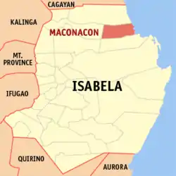 Map of Isabela with Maconacon highlighted | |
OpenStreetMap 
| |
.svg.png.webp)  Maconacon Location within the Philippines | |
| Coordinates: 17°23′14″N 122°14′17″E | |
| Country | Philippines |
| Region | Cagayan Valley |
| Province | Isabela |
| District | 1st district |
| Barangays | 10 (see Barangays) |
| Government | |
| • Type | Sangguniang Bayan |
| • Mayor | Ma. Lycelle Kate D. Vicente |
| • Vice Mayor | Jolly A. Taberner |
| • Representative | Antonio T. Albano |
| • Electorate | 2,907 voters (2019) |
| Area | |
| • Total | 538.66 km2 (207.98 sq mi) |
| Elevation | 113 m (371 ft) |
| Highest elevation | 903 m (2,963 ft) |
| Lowest elevation | 0 m (0 ft) |
| Population | |
| • Total | 3,977 |
| • Density | 7.4/km2 (19/sq mi) |
| • Households | 935 |
| Economy | |
| • Income class | 3rd municipal income class |
| • Poverty incidence | 20.86% (2015)[4] |
| • Revenue | ₱147,641,472.97 (2020) |
| • Assets | ₱259,673,941.97 (2020) |
| • Expenditure | ₱131,642,521.06 (2020) |
| • Liabilities | ₱39,716,328.61 (2020) |
| Service provider | |
| • Electricity | Isabela 2 Electric Cooperative (ISELCO 2) |
| Time zone | UTC+8 (PST) |
| ZIP code | 3333 |
| PSGC | |
| IDD : area code | +63 (0)78 |
| Native languages | Ibanag Ilocano Atta language Dupaningan Agta Kasiguranin Tagalog |
Geography
Maconacon is one of the four coastal municipalities of the province of Isabela facing the Philippine Sea to the east. Separated from the rest of the province by the mighty Sierra Madre mountains, it is considered to be one of the most remote and isolated community in the province.
The town is bounded to the north by Peñablanca in the province of Cagayan, San Pablo and Cabagan to the west, Tumauini to the southwest, Divilacan to the south and the Philippine Sea to the east.
Barangays
Climate
| Climate data for Maconacon | |||||||||||||
|---|---|---|---|---|---|---|---|---|---|---|---|---|---|
| Month | Jan | Feb | Mar | Apr | May | Jun | Jul | Aug | Sep | Oct | Nov | Dec | Year |
| Average high °C (°F) | 28.2 (82.8) |
29.7 (85.5) |
30.7 (87.3) |
32.5 (90.5) |
33.8 (92.8) |
33.8 (92.8) |
33.0 (91.4) |
32.7 (90.9) |
32.3 (90.1) |
31.4 (88.5) |
29.7 (85.5) |
28.3 (82.9) |
31.3 (88.4) |
| Daily mean °C (°F) | 24.0 (75.2) |
24.8 (76.6) |
26.3 (79.3) |
27.9 (82.2) |
29.0 (84.2) |
29.1 (84.4) |
28.6 (83.5) |
28.4 (83.1) |
28.1 (82.6) |
27.5 (81.5) |
25.9 (78.6) |
24.6 (76.3) |
27.0 (80.6) |
| Average low °C (°F) | 19.9 (67.8) |
20.0 (68.0) |
21.9 (71.4) |
23.3 (73.9) |
24.2 (75.6) |
24.5 (76.1) |
24.3 (75.7) |
24.2 (75.6) |
24.0 (75.2) |
23.6 (74.5) |
22.1 (71.8) |
21.0 (69.8) |
22.8 (73.0) |
| Average rainfall mm (inches) | 94 (3.7) |
55 (2.2) |
63 (2.5) |
55 (2.2) |
112 (4.4) |
160 (6.3) |
175 (6.9) |
208 (8.2) |
188 (7.4) |
382 (15.0) |
467 (18.4) |
251 (9.9) |
2,210 (87.1) |
| Source: Climate-Data.org[6] | |||||||||||||
Maconacon has a tropical monsoon climate (Am) with moderate rainfall from January to May and heavy to very heavy rainfall from June to December.
Demographics
|
| ||||||||||||||||||||||||||||||||||||
| Source: Philippine Statistics Authority [7] [8] [9][10] | |||||||||||||||||||||||||||||||||||||
In the 2020 census, the population of Maconacon was 3,977 people, [3] with a density of 7.4 inhabitants per square kilometre or 19 inhabitants per square mile.
Economy
| Poverty Incidence of Maconacon | |
| Source: Philippine Statistics Authority[11][12][13][14][15][16] | |
Transportation
Maconacon is accessible via sea and air. Its primary gateway is the Maconacon Airport which connects this isolated town to the rest of the province through Cauayan Airport, also in Cauayan City.
References
- Municipality of Maconacon | (DILG)
- "2015 Census of Population, Report No. 3 – Population, Land Area, and Population Density" (PDF). Philippine Statistics Authority. Quezon City, Philippines. August 2016. ISSN 0117-1453. Archived (PDF) from the original on May 25, 2021. Retrieved July 16, 2021.
- Census of Population (2020). "Region II (Cagayan Valley)". Total Population by Province, City, Municipality and Barangay. PSA. Retrieved 8 July 2021.
- https://psa.gov.ph/sites/default/files/City%20and%20Municipal-level%20Small%20Area%20Poverty%20Estimates_%202009%2C%202012%20and%202015_0.xlsx; publication date: 10 July 2019; publisher: Philippine Statistics Authority.
- "Province: Isabela". PSGC Interactive. Quezon City, Philippines: Philippine Statistics Authority. Retrieved 12 November 2016.
- "Climate: Maconacon". Climate-Data.org. Retrieved 27 October 2020.
- Census of Population (2015). "Region II (Cagayan Valley)". Total Population by Province, City, Municipality and Barangay. PSA. Retrieved 20 June 2016.
- Census of Population and Housing (2010). "Region II (Cagayan Valley)". Total Population by Province, City, Municipality and Barangay. NSO. Retrieved 29 June 2016.
- Censuses of Population (1903–2007). "Region II (Cagayan Valley)". Table 1. Population Enumerated in Various Censuses by Province/Highly Urbanized City: 1903 to 2007. NSO.
- "Province of Isabela". Municipality Population Data. Local Water Utilities Administration Research Division. Retrieved 17 December 2016.
- "Poverty incidence (PI):". Philippine Statistics Authority. Retrieved 28 December 2020.
- https://psa.gov.ph/sites/default/files/NSCB_LocalPovertyPhilippines_0.pdf; publication date: 29 November 2005; publisher: Philippine Statistics Authority.
- https://psa.gov.ph/sites/default/files/2003%20SAE%20of%20poverty%20%28Full%20Report%29_1.pdf; publication date: 23 March 2009; publisher: Philippine Statistics Authority.
- https://psa.gov.ph/sites/default/files/2006%20and%202009%20City%20and%20Municipal%20Level%20Poverty%20Estimates_0_1.pdf; publication date: 3 August 2012; publisher: Philippine Statistics Authority.
- https://psa.gov.ph/sites/default/files/2012%20Municipal%20and%20City%20Level%20Poverty%20Estima7tes%20Publication%20%281%29.pdf; publication date: 31 May 2016; publisher: Philippine Statistics Authority.
- https://psa.gov.ph/sites/default/files/City%20and%20Municipal-level%20Small%20Area%20Poverty%20Estimates_%202009%2C%202012%20and%202015_0.xlsx; publication date: 10 July 2019; publisher: Philippine Statistics Authority.
External links
 |
Wikimedia Commons has media related to Maconacon. |
- Municipal Profile at the National Competitiveness Council of the Philippines
- Maconacon at the Isabela Government Website
- Local Governance Performance Management System
- Philippine Standard Geographic Code
- Philippine Census Information
- Municipality of Maconacon
Places adjacent to Maconacon | |
|---|---|


 Province of Isabela Province of Isabela | |
|---|---|
Ilagan (capital) | |
| Municipalities |
|
| Component Cities | |
| Independent Component City |
|
| Barangays | |