Capricorn Highway
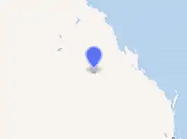
The Capricorn Highway is located in Central Queensland, Australia, and links the city of Rockhampton with western Queensland.[1] The highway is 575 kilometres long, and joins the Landsborough Highway at Barcaldine.[2] Formerly National Route 66, Queensland began to convert to the alphanumeric system much of Australia had adopted in the early-2000s and is now designated as A4. The highway runs parallel with the Tropic of Capricorn, hence its name.
Capricorn Highway | |
|---|---|
| |
| General information | |
| Type | Highway |
| Length | 575 km (357 mi) |
| Route number(s) |
|
| Former route number |  National Route 66 National Route 66 |
| Major junctions | |
| West end |  Landsborough Highway (National Highway A2), Barcaldine Landsborough Highway (National Highway A2), Barcaldine |
 Gregory Highway (State Highway A7) Gregory Highway (State Highway A7) Leichhardt Highway (State Highway A5) Leichhardt Highway (State Highway A5) | |
| East end |  Bruce Highway (Queensland Highway A1), Rockhampton Bruce Highway (Queensland Highway A1), Rockhampton |
| Location(s) | |
| Major settlements | Jericho, Alpha, Emerald, Blackwater, Gogango, Westwood |
| Highway system | |

Other towns situated along the highway include (from east to west): Gracemere, Kabra, Stanwell, Westwood, Gogango, Duaringa, Dingo, Bluff, Blackwater, Comet, Emerald, Bogantungan, Alpha and Jericho.
Running virtually east/west, the highway traverses the area known as the Central Highlands, and crosses the Great Dividing Range between Alpha and Jericho.
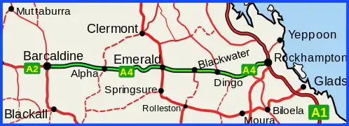 Capricorn Highway (green on black)
Major intersections
| LGA | Location | km | mi | Destinations | Notes |
|---|---|---|---|---|---|
| Barcaldine | Barcaldine | 0 | 0.0 | Landsborough Highway (National Route A2) west - Longreach / south - Blackall | Western end of Capricorn Highway |
| Central Highlands | Emerald | 309 | 192 | Gregory Highway (State Route A7) north - Clermont | Western concurrency terminus with Gregory Highway |
| 311 | 193 | Gregory Highway (State Route A7) south - Springsure | Eastern concurrency terminus with Gregory Highway | ||
| Dingo | 432 | 268 |  Fitzroy Developmental Road (State Route 67) north - Middlemount Fitzroy Developmental Road (State Route 67) north - Middlemount | ||
| Rockhampton | Westwood | 522.9 | 324.9 | Leichhardt Highway (State Route A5) south - Banana and Biloela | |
| Rockhampton | 574.6 | 357.0 | Bruce Highway (Queensland Highway A1) north - Rockhampton / south - Mount Larcom | Eastern end of Capricorn Highway. Intersection is approximately 4.1 km from Rockhampton CBD | |
1.000 mi = 1.609 km; 1.000 km = 0.621 mi
| |||||
References
- Queensland Government - Department of Transport and Main Roads - Maps
- Hema, Maps (2007). Australia Road and 4WD Atlas (Map). Eight Mile Plains Queensland: Hema Maps. pp. 10–11. ISBN 978-1-86500-456-3.