Peak Downs Highway
The Peak Downs Highway links the towns of Mackay and Clermont in the Australian state of Queensland.[1] It represents the main link between Queensland's Whitsunday Coast and the Central West region of the state. The highway runs for a total length of 266 kilometres (165 mi), before joining the Gregory Highway (Highway A7, formerly Highway 55) south to Clermont, a total of 283 kilometres (176 mi).[2] Major settlements served by this route include Walkerston, Nebo, Moranbah (10 kilometres (6.2 mi) north of the highway, but the largest town along the route) and Clermont.
Peak Downs Highway | |
|---|---|
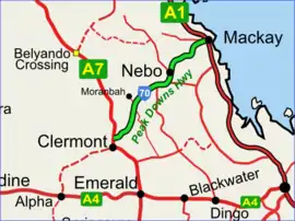 | |
Peak Downs Highway depicted in green on black. | |
| General information | |
| Type | Highway |
| Length | 283 km (176 mi) |
| Route number(s) |  State Route 70 State Route 70 |
| Major junctions | |
| East end |  Bruce Highway, Mackay, Queensland Bruce Highway, Mackay, Queensland |
| |
| West end |  Clermont Alpha Road (State Route 41), Clermont, Queensland Clermont Alpha Road (State Route 41), Clermont, Queensland |
| Location(s) | |
| Major settlements | Moranbah, Nebo, Eton |
| Highway system | |
Highway conditions
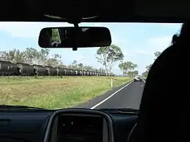
The highway is notorious for the extremely dangerous conditions caused by its service as a primary access route for workers, fuel, machinery and other supplies to the coal mines of the Bowen Basin. The narrow two-lane highway is often congested with oversize loads (e.g. mining haul-trucks, dozers and excavators, tyres and buckets) and road trains, which presents a significant hazard and frustration to fatigued long-haul commuters (Drive-in, Drive-out mine workers) on the road.
Major intersections
| LGA | Location | km | mi | Destinations | Notes |
|---|---|---|---|---|---|
| Mackay | West Mackay, Paget, Ooralea tripoint | 0 | 0.0 | Bruce Highway (Queensland Highway A1) - south - Sarina / north-east - Mackay | North-eastern end of Peak Downs Highway (State Route 70) |
| Racecourse, Te Kowai midpoint | 2.7 | 1.7 | Mackay Ring Road - north - Glenella south - Bakers Creek | No entry from Mackay Ring Road northbound. | |
| Alexandra | 6.4 | 4.0 |  Mackay Eungella Road (State Route 64) - north-west - Marian Mackay Eungella Road (State Route 64) - north-west - Marian | ||
| Eton | 25.1 | 15.6 |  Marian Eton Road (State Route 5) - north-west - Marian Marian Eton Road (State Route 5) - north-west - Marian | Eastern concurrency terminus with State Route 5 | |
| 25.8 | 16.0 | Eton Homebush Road (State Route 5) - south-east - Homebush | Western concurrency terminus with State Route 5 | ||
| Isaac | Nebo | 82 | 51 |  Suttor Developmental Road (State Route 11) - west - Mount Coolon Suttor Developmental Road (State Route 11) - west - Mount Coolon | |
| Strathfield, Oxford midpoint | 117 | 73 |  Fitzroy Developmental Road (State Route 67) - south - Dingo Fitzroy Developmental Road (State Route 67) - south - Dingo | ||
| Clermont | 266 | 165 |  Gregory Highway (State Route A7) - south - Clermont town centre / Gregory Highway (State Route A7) - south - Clermont town centre /north - Charters Towers | Northern concurrency terminus with Gregory Highway | |
| 280 | 170 | Gregory Highway (State Route A7) - south-east - Emerald | Southern concurrency terminus with Gregory Highway | ||
| 283 | 176 | Clermont Alpha Road (State Route 41) - west - Alpha | South-western end of Peak Downs Highway | ||
1.000 mi = 1.609 km; 1.000 km = 0.621 mi
| |||||
References
- Queensland Government - Department of Transport and Main Roads - Maps
- Hema, Maps (2007). Australia Road and 4WD Atlas (Map). Eight Mile Plains Queensland: Hema Maps. pp. 10–11. ISBN 978-1-86500-456-3.
