Circumferential Road 4
Circumferential Road 4 (C-4), informally known as the C-4 Road, is a network of roads and bridges that all together form the fourth beltway of Metro Manila in the Philippines.[1] Spanning some 28.1 kilometers (17.5 mi), it connects the cities of Caloocan, Makati, Malabon, Mandaluyong, Navotas, Pasay, Quezon City, and San Juan.
C-4
Circumferential Road 4 | |
|---|---|
| C-4 Road | |
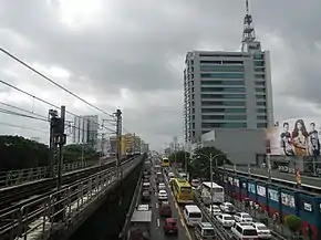 EDSA southbound as viewed from Kamuning MRT station | |
| Route information | |
| Maintained by the Department of Public Works and Highways and the Metro Manila Development Authority | |
| Length | 28.1 km (17.5 mi) |
| Component highways |
|
| Major junctions | |
| Beltway around Manila | |
| North end | _sign.svg.png.webp) AH 26 (N120) (Radial Road 10) in Navotas AH 26 (N120) (Radial Road 10) in Navotas |
| South end | .svg.png.webp) AH 26 (N120) / N61 (Roxas Boulevard) in Pasay AH 26 (N120) / N61 (Roxas Boulevard) in Pasay |
| Location | |
| Major cities | Caloocan, Makati, Malabon, Mandaluyong, Navotas, Pasay, Quezon City, and San Juan |
| Highway system | |
| |
_sign.svg.png.webp)
.svg.png.webp)
Route description
C-4 Road
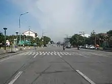
The section of C-4 Road is simply known as such from R-10 at the Bangkulasi Bridge over Tullahan River in Navotas to Paterio Aquino Avenue (Letre Road) at the boundary of Malabon and Caloocan.
Gen. San Miguel Street
After passing Paterio Aquino Avenue (Letre Road), C-4 becomes General San Miguel Street, a four-lane road in Caloocan.
Samson Road
After passing the junction with Marcelo H. Del Pilar and A. Mabini Streets in Caloocan, C-4 becomes Samson Road. Also called "Caloocan Road" and "Monumento Avenue", it is a main road in Caloocan with four lanes, running up to the roundabout at Monumento, a monument to Andrés Bonifacio.
Epifanio de los Santos Avenue
EDSA is a 10-lane highway that utilizes interchanges and grade separations. EDSA forms the majority portion of the Circumferential Road 4 (C-4) in Metro Manila, passing through the cities of Caloocan, Quezon City, San Juan, Mandaluyong, Makati, and Pasay. The C-4 segment of EDSA starts at Monumento in Caloocan and ends at the intersection with Roxas Boulevard in Pasay.
Intersections
| Intersection | Location | Remarks |
|---|---|---|
| Radial Road 10 Junction | Navotas | Northern terminus of the C-4 Road; goes to Manila |
| Dagat-Dagatan Avenue Intersection | Malabon & Caloocan | Dagat-Dagat Avenue goes to C-3 Road |
| Paterio Aquino Avenue | Malabon & Caloocan | |
| A. Mabini Street & M.H. Del Pilar Street | Caloocan | Terminus of Gen. San Miguel Street and Samson Road. A. Mabini Street leads to Caloocan and Manila, while M.H. Del Pilar Street leads to Malabon and Valenzuela. |
| PNR Orange Line crossing | Caloocan | |
| Monumento Roundabout | Caloocan | MacArthur Highway goes to Northern and Central Luzo, while Rizal Avenue Extension goes to Manila. C-4 continues to the east as EDSA. |
See also
References
- "Metro Manila Infrastructure Development" (PDF). University of the Philippines Diliman. Retrieved June 6, 2020.
 |
Wikimedia Commons has media related to Circumferential Road 4. |
