Roosevelt Avenue, Quezon City
Roosevelt Avenue (Tagalog: [ˈruːsbɛlt]) is the principal north–south road serving the San Francisco del Monte district (colloquially known as Frisco) of Quezon City, Philippines. It runs between Epifanio de los Santos Avenue (EDSA) to the north and Quezon Avenue to the south. It is named after U.S. president Franklin D. Roosevelt.[2]
 | |
|---|---|
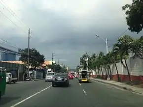 Roosevelt Avenue looking north towards EDSA by the Coca-Cola plant | |
| Route information | |
| Maintained by the Department of Public Works and Highways – Quezon City 1st District Engineering Office[1] and Metropolitan Manila Development Authority | |
| Length | 2.9 km (1.8 mi) |
| Major junctions | |
| North end | _sign.svg.png.webp) AH 26 (N1) in Muñoz AH 26 (N1) in Muñoz |
| South end | .svg.png.webp) N170 (Quezon Avenue) in Santa Cruz N170 (Quezon Avenue) in Santa Cruz |
| Location | |
| Major cities | Quezon City |
| Highway system | |
| |
The avenue and the adjacent area are also referred to by local residents as Muñoz, being the site of a popular wet market, the Muñoz Market, located at Roosevelt and EDSA. The market was named after its owner Demetrio Muñoz, a philanthropist, businessman and a presidential adviser during the term of Diosdado Macapagal from the province of Pampanga.[3] At the opposite end of Roosevelt on Quezon Avenue is Fisher Mall, a commercial establishment built on the land that used to be the main terminal of the Pangasinan Transportation Company (PANTRANCO) that went bankrupt in 1993.[4] Roosevelt Avenue is also home to the transmitter of television station Intercontinental Broadcasting Corporation (IBC-13).
Renaming proposals
In 2010, a bill was authored in Congress by Quezon City's 1st congressional district representative Vincent Crisologo renaming the avenue after his predecessor, former Representative Reynaldo Calalay.[5]
On September 13, 2021, Senate approved a bill that seeks to rename the avenue after the actor Fernando Poe Jr.[6]
Route description
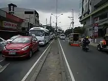
Roosevelt Avenue is located northeast of Manila and runs for roughly 2.9 kilometres (1.8 mi) along a north–south axis. Starting at its southern terminus at the junction with Quezon Avenue in Barangay Santa Cruz, the road heads north toward Barangay Paraiso providing access to Damayan, site of the old Santuario de San Pedro Bautista church of the former pueblo of San Francisco del Monte built in 1593. It intersects with Del Monte Avenue from where it continues on a straight path north through the mixed residential and industrial villages of San Antonio and Paltok where a Coca-Cola plant stands next to the IBC transmitter. The road ends at the intersection with EDSA by the Muñoz public market and Walter Mart North Edsa.
North of EDSA, Roosevelt continues as Congressional Avenue heading northeast to Project 8 and Culiat area. It is served by Roosevelt station of the LRT Line 1.
References
- "Quezon City 1st". Retrieved May 22, 2020.
- "Metro Manila streets named after American leaders". Rappler. Retrieved 1 April 2015.
- Municipality of Minalin -Famous people published by the Provincial Government of Pampanga; accessed 2013-12-20.
- https://business.inquirer.net/71865/court-of-appeals-upholds-auction-of-pantranco-buses-to-rival-firms
- Spot.ph's Top 20 Crazy Laws in the Philippines published by Spot.ph; accessed 2013-12-21.
- "Senate renames Roosevelt Avenue to Fernando Poe Jr. Avenue". Senate of the Philippines. September 13, 2021. Retrieved September 21, 2021.
 |
Wikimedia Commons has media related to Roosevelt Avenue, Quezon City. |
