Eslamabad-e Gharb County
Eslamabad-e Gharb County (Persian: شهرستان اسلامآباد غرب) is a county in Kermanshah Province in Iran, part of what is unofficially referred to as Iranian Kurdistan. The capital of the county is Eslamabad-e Gharb. At the 2006 census, the county's population was 149,376, in 34,270 families.[1] The county is subdivided into two districts: the Central District and Homeylt. The county has two cities: Eslamabad-e Gharb and Homeyl.
Eslamabad-e Gharb County
شهرستان اسلامآباد غرب | |
|---|---|
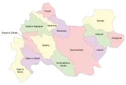 Counties of Kermanshah Province | |
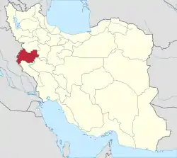 Location of Kermanshah Province in Iran | |
| Coordinates: 34°03′N 46°40′E | |
| Country |  Iran Iran |
| Province | Kermanshah |
| Capital | Eslamabad-e Gharb |
| Bakhsh (Districts) | Central District, Homeyl District |
| Population (2006) | |
| • Total | 149,376 |
| Time zone | UTC+3:30 (IRST) |
| • Summer (DST) | UTC+4:30 (IRDT) |
| Eslamabad-e Gharb County can be found at GEOnet Names Server, at this link, by opening the Advanced Search box, entering "9206870" in the "Unique Feature Id" form, and clicking on "Search Database". | |
Archeological Context (by Kamyar Abdi) The epigraphic material presented here was discovered in 1970 duringa series of salvage excavations in an architectural complex at the site of Chogha Gavaneh in the middle of the town of Shahabad-e Gharb (formerly known as Harunabad, renamed Islam abad e gharb after the 1979 Iranian Revolution)about 60 Km to the west of Kermanshah in westen Iran.[2] Research at Chogha Gavaneh Several early travelers (cf. Jones 1857) passed through the Islamabad Plain (then called the Harunabad Plain) in the nineteenth and early twentieth centuries, but none seem to have remarked on the archaeological remains in the area. The ˜rst traveler/archaeologist to give a brief description of the region was Aurel Stein, who visited the town of Harunabad in 1936 during his general survey of western Iran (Stein 1940: 420). Later the same year Erich Schmidt ˘ew over the Plain during his aerial reconnaissance in western Iran (Schmidt 1940). In 1959–1960, as part of the Iranian Prehistory Project of the Oriental Institute of the University of Chicago, Robert Braidwood and his team brie˘y surveyed the Plain (Braidwood 1961), but they do not seem to have explored Chogha Gavaneh in any detail.A few years later, Clare Goˆ (1966) of the British Institute of Persian Studies visited the Plain during her general survey of the Central Zagros Mountains. The ˜rst series of archaeological excavations at Chogha Gavaneh were carried out in 1967 by Ali-Akbar Karegar Sarfaraz, Mohammad-Rahim Sarraf, and Ismai’l Yaghma’i (from the then Archaeological Service of Iran). This team opened a step trench at the northeast side of the high mound to study its stratigraphy, ˜nding levels from the Chalcolithic Period to the Iron Age as well as disturbed remains of later periods. Following the 1967 ˜eldwork, although the site was registered in the list of national monuments, infringements upon Chogha Gavaneh by the locals intensi˜ed. In a matter of just three years, as a result of the growth of the town, the slopes of the high mound were covered with houses. Early in 1970, the town municipality cleared the conical-shaped top of the mound to establish a tea house. Noti˜ed of these activities, the Archaeological Service of Iran dispatched Mahmoud Kordevani to prevent further damage to the site and conduct excavations in quarried areas. For three months in the summer of 1970, Kordevani and his team cleared an area of about 0.8 hectares on the top of the high mound, exposing a major architectural complex. The ˜nds from this architectural complex— including the collection of tablets discussed here—and the evidence for con˘agration in some places led Kordevani (1971: 46–50) to date the complex to the late Iron Age II of the Central Zagros(ca. 800 B.C.) and to interpret it as one of many settlements the Neo-Assyrian kings claimed to have sacked and burned in the Zagros.
References
- "Census of the Islamic Republic of Iran, 1385 (2006)" (Excel). Statistical Center of Iran. Archived from the original on 2011-11-11.
- Abdi, K., & Beckman, G. (2007). An early second-millennium cuneiform archive from Chogha Gavaneh, western Iran. Journal of cuneiform studies, 39-91.
- اطلس گیتاشناسی استانهای ایران [Atlas Gitashenasi Ostanhai Iran] (Gitashenasi Province Atlas of Iran)
| Capital |  | |
|---|---|---|
| Counties and cities | ||
| Sights |
| |
| populated places | ||