List of extreme points of Vietnam
The extreme points of Vietnam include the coordinates that are further north, south, west and east than any other location in Vietnam's territory; and the highest and the lowest altitudes in Vietnam. Because Vietnam location eastern Indochina peninsula, the north point and west point lying on the land, and two south point and two east point location along and inside East Sea. Vietnam's territory stretching along the coast of East Sea, from the north to the south distant between the north point and the south point more than 1.650 km.[1] Most extreme points are not in dispute with any other countries, all administered by Vietnam. Only one extreme points Tennent Reef is disputed by China, Taiwan, Philippines, this is a part of Spratly Islands dispute, but Tennent Reef now administered by Vietnam.
The latitude and longitude are expressed in decimal degree notation, in which a positive latitude value refers to the northern hemisphere, and a negative value refers to the southern hemisphere. Similarly, a positive longitude value refers to the eastern hemisphere, and a negative value refers to the western hemisphere. The coordinates used in this article are sourced from Google Earth, which makes use of the WGS84 geodetic reference system. Additionally, a negative altitude value refers to land below sea level.
Extreme points
- Color Notes
extreme points on mainland (2) extreme points on coast (2) extreme points on sea (2)
| # | Heading | Location | Administrative entity | Bordering entity | Coordinates[nb 1] | Ref | Image |
|---|---|---|---|---|---|---|---|
| North | Lũng Cú commune, Đồng Văn district | Hà Giang | Yunnan, China | 23.392505°N 105.323240°E | [2] |  Cột cờ Lũng Cú. | |
| West | A Pa Chải-Tá Miếu (Sín Thầu, Mường Nhé district) | Điện Biên[3][4] | Border tripoint Vietnam-China-Laos (Điện Biên-Yunnan-Phongsaly) | 22.400734°N 102.143940°E | [5] | ||
| South (on mainland) | cape Cà Mau, Ngọc Hiển district | Cà Mau | South China sea | 8.623°N 104.71°E | [6] | 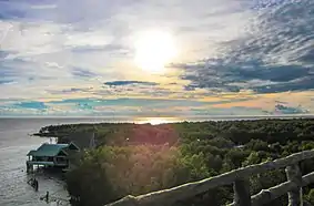 | |
| South (on sea) | Hòn Khoai islands | Cà Mau | South China sea | 8.4344°N 104.8336°E (approximately) | [7] | ||
| East (on mainland) | cape Đôi on Hòn Gốm peninsula, Vân Phong Bay, Vạn Thạnh, Vạn Ninh district | Khánh Hòa | South China sea | 12.6483756°N 109.4616339°E | [8] | ||
| East (on sea) | at Tennent Reef, Spratly Islands, Trường Sa District | Khánh Hòa | South China sea | 8.855°N 114.655°E | [9][10] | %252C_Spratly_Islands.png.webp) Da Tien Nu. |
Altitudes
| # | Extremity | Name | Altitude | Location | Province | Coordinates | Ref | Image |
|---|---|---|---|---|---|---|---|---|
| Highest | Phan Xi Păng | 3.143 m (10.312 ft) | Hoàng Liên Sơn, northwest of Việt Nam | between Lào Cai and Lai Châu Province | 22.304276°N 103.777063°E | [11] |  | |
| Lowest | sea surface | 0 m | South China sea | - | - | [12][13][14] | 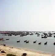 East sea, cape mũi Né. |
See also
Notes
- Coordinates obtained from Google Earth. Google Earth makes use of the WGS84 geodetic reference system.
References
- "Vietnam, geography". Đại sứ quán Việt Nam tại Mỹ (EMBASSY OF THE Socialist Republic of Vietnam IN THE UNITED STATES OF AMERICA). Archived from the original on 22 September 2019. Retrieved 26 May 2019.
- "Google Maps (cực Bắc)". Google. Retrieved 2019-05-25.
- Đường đến cực tây A Pa Chải, Retrieved 26 May 2019
- Vietnam Television, Hành trình A Pa Chải, Retrieved 26 May 2019
- "Google Maps (cực Tây)". Google. Retrieved 2019-05-25.
- "Google Maps (cực Nam-đất liền)". Google. Retrieved 2019-05-25.
- "Google Maps (cực Nam-trên biển)". Google. Retrieved 2019-05-26. (near exactly)
- "Google Maps (cực Đông-đất liền)". Google. Retrieved 2019-05-25.
- "Google Maps (cực Đông-trên biển)". Google. Retrieved 2019-05-25.
- Thăm đèn Tiên Nữ, ngọn hải đăng ở Trường Sa, Retrieved 26 May 2019
- "Southeast Asia" Ultra-Page, Retrieved 26 May 2019
- Highest And Lowest Points In Countries Islands Oceans Of The World, Retrieved 26 May 2019
- Highest and Lowest Point - Vietnam, Retrieved 26 May 2019
- GEOGRAPHY OF VIETNAM, Retrieved 26 May 2019
| History |
|   | |||||||||||||||
|---|---|---|---|---|---|---|---|---|---|---|---|---|---|---|---|---|---|
| Geography |
| ||||||||||||||||
| Politics |
| ||||||||||||||||
| Economy | |||||||||||||||||
| Society |
| ||||||||||||||||
| Sovereign states |
|
|---|---|
| States with limited recognition |
|
| Dependencies and other territories |
|
| |

