Highway M13 (Ukraine)
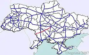
M13 is a Ukrainian international highway (M-highway) connecting Kropyvnytskyi to the border with Moldova, where before crossing the Dniester it heads towards Chişinău as the M21.[1][2]
 | |
|---|---|
 | |
| Route information | |
| Length | 254.4 km (158.1 mi) |
| Major junctions | |
| East end |  M 12 in Kropyvnytskyi M 12 in Kropyvnytskyi |
 M 05 in Liubashivka M 05 in Liubashivka | |
| West end | Moldovan border in Platonove |
| Location | |
| Regions | Odessa Oblast, Mykolaiv Oblast, Kirovohrad Oblast |
| Highway system | |
| Roads in Ukraine | |
Main Route
Main route and connections to/intersections with other highways in Ukraine.
| Marker | Main settlements | Notes | Highway Interchanges |
|---|---|---|---|
| 0 km | Kropyvnytskyi |  E 50/ E 50/ E 471 M 12 • E 471 M 12 •  H 14 • H 14 •  H 23 H 23 | |
| Liubashivka |  E 95 M 05 E 95 M 05 | ||
| 254 km | Platonove / Border (Moldova) |  E 584M21 E 584M21  |
- Note
Technically the route crosses Transnistria.
External links
- International Roads in Ukraine in Russian
- European Roads in Russian
| E-roads in Ukraine |   | |
|---|---|---|
| International | ||
| National | ||
| Regional |
| |
| ||
This article is issued from Wikipedia. The text is licensed under Creative Commons - Attribution - Sharealike. Additional terms may apply for the media files.