North Kolaka Regency
North Kolaka Regency is a regency in the northwest part of Southeast Sulawesi province of Indonesia. It covers an area of 2,924.46 km2,[2] and had a population of 121,476 at the 2010 Census,[3] and 137,700 at the 2020 Census.[4] The principal town lies at Lasusua.
North Kolaka Regency
Kabupaten Kolaka Utara | |
|---|---|
 Seal | |
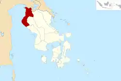 Location within Southeast Sulawesi | |
| Coordinates: 3°20′14″S 121°02′38″E | |
| Country | Indonesia |
| Province | Southeast Sulawesi |
| Capital | Lasusua |
| Government | |
| • Regent | Nur Rahman Umar |
| • Vice Regent | Abass |
| Area | |
| • Total | 2,924.46 km2 (1,129.14 sq mi) |
| Population (2020 Census)[1] | |
| • Total | 137,700 |
| • Density | 47/km2 (120/sq mi) |
| Time zone | UTC+8 (ICST) |
| Area code | (+62) 405 |
| Website | kolutkab |

Administration
The North Kolaka Regency is divided into fifteen districts (kecamatan), tabulated below with their areas[5] and their populations at the 2010 Census[6] and the 2020 Census.[7] The table also includes the location of the district administrative centres.
| Name | Area in km2 | Population Census 2010 | Population Census 2020 | Admin centre |
|---|---|---|---|---|
| Ranteangin | 83.35 (189.92) | 5,301 | 6,000 | Ranteangin |
| Lambai | 97.97 (162.74) | 5,308 | 6,400 | Lambai |
| Wawo | 260.96 (234.99) | 5,615 | 6,800 | Wawo |
| Lasusua | 269.32 (287.67) | 21,756 | 27,200 | Lasusua |
| Katoi | 144.49 (82.64) | 5,763 | 6,900 | Katoi |
| Kodeoha | 137,26 (250.49) | 10,644 | 11,300 | Mala-Mala |
| Tiwu | 35.47 (81.92) | 4,042 | 4,600 | Tiwu |
| Ngapa | 222.71 (149.18) | 17,355 | 17,300 | Lapai |
| Watunohu | 33.40 (109.99) | 6,212 | 6,700 | Watunohu |
| Pakue | 150.68 (313.25) | 9,345 | 10,300 | Olo-Oloho |
| Pakue Utara (North Pakue) | 223.80 (131.25) | 6,966 | 8,000 | Pakue |
| Pakue Tengah (Central Pakue) | 174.47 (191.82) | 6,132 | 7,500 | Latali |
| Batu Putih | 236.56 (374.95) | 7,372 | 8,500 | Batu Putih |
| Porehu | 571.60 (647.23) | 6,936 | 6,700 | Porehu |
| Tolala | 282.42 (183.58) | 2,593 | 3,500 | Tolala |
| Totals | 2,924.46 (3,391.62) | 121,476 | 137,659 | Lasusua |
Climate
Lasusua, the seat of the regency has a tropical rainforest climate (Af) with moderate rainfall in October and November and heavy to very heavy rainfall in the remaining months.
| Climate data for Lasusua | |||||||||||||
|---|---|---|---|---|---|---|---|---|---|---|---|---|---|
| Month | Jan | Feb | Mar | Apr | May | Jun | Jul | Aug | Sep | Oct | Nov | Dec | Year |
| Average high °C (°F) | 30.6 (87.1) |
30.7 (87.3) |
30.9 (87.6) |
31.1 (88.0) |
30.9 (87.6) |
30.2 (86.4) |
30.0 (86.0) |
30.8 (87.4) |
31.5 (88.7) |
32.3 (90.1) |
31.9 (89.4) |
31.1 (88.0) |
31.0 (87.8) |
| Daily mean °C (°F) | 26.8 (80.2) |
27.0 (80.6) |
27.1 (80.8) |
27.2 (81.0) |
27.2 (81.0) |
26.4 (79.5) |
26.0 (78.8) |
26.3 (79.3) |
26.8 (80.2) |
27.4 (81.3) |
27.6 (81.7) |
27.2 (81.0) |
26.9 (80.5) |
| Average low °C (°F) | 23.1 (73.6) |
23.3 (73.9) |
23.3 (73.9) |
23.3 (73.9) |
23.5 (74.3) |
22.7 (72.9) |
22.0 (71.6) |
21.9 (71.4) |
22.1 (71.8) |
22.6 (72.7) |
23.3 (73.9) |
23.3 (73.9) |
22.9 (73.1) |
| Average rainfall mm (inches) | 158 (6.2) |
169 (6.7) |
191 (7.5) |
238 (9.4) |
361 (14.2) |
298 (11.7) |
228 (9.0) |
192 (7.6) |
177 (7.0) |
123 (4.8) |
118 (4.6) |
137 (5.4) |
2,390 (94.1) |
| Source: Climate-Data.org[8] | |||||||||||||
References
- Badan Pusat Statistik, Jakarta, 2021.
- This is the figure recorded by the regency BPS; the figure quoted by the province BPS is 3,391.67 km2.
- Biro Pusat Statistik, Jakarta, 2011.
- Badan Pusat Statistik, Jakarta, 2021.
- Two figures are quoted for each district; the first is that given by the reggency BPS, while the second (in brackets) is that quoted by the province BPS.
- Biro Pusat Statistik, Jakarta, 2011.
- Badan Pusat Statistik, Jakarta, 2021.
- "Climate: Lasusua". Climate-Data.org. Retrieved 22 November 2020.
Regencies and cities of Southeast Sulawesi | ||
|---|---|---|
Capital: Kendari | ||
| Regencies |  | |
| Cities | ||
Authority control  | |
|---|---|
| General | |
| National libraries | |
This article is issued from Wikipedia. The text is licensed under Creative Commons - Attribution - Sharealike. Additional terms may apply for the media files.