Probolinggo Regency
Probolinggo Regency (Indonesian: Kabupaten Probolinggo) is a regency in East Java province of Indonesia. It covers an area of 1,696.17 sq. km, and had a population of 1,096,244 at the 2010 Census[1] and 1,152,537 at the 2020 Census.[2] Its capital was formerly the city of Probolinggo, but after that city became an independent administrative identity the capital is now at Kraksaan.
Probolinggo Regency | |
|---|---|
 Coat of arms | |
| Motto(s): Prasaja Ngesti Wibawa (By modesty for the sake of dignity) | |
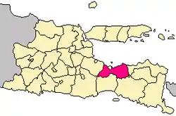 Location within East Java | |
| Coordinates: 7°44′07″S 113°28′18″E | |
| Country | Indonesia |
| Region | Java |
| Province | East Java |
| Capital | Kraksaan |
| Government | |
| • Regent | Puput Tantriana Sari |
| • Vice Regent | Timbul Prihanjoko |
| Area | |
| • Total | 1,696.17 km2 (654.89 sq mi) |
| Population (2020 Census) | |
| • Total | 1,152,537 |
| • Density | 680/km2 (1,800/sq mi) |
| Time zone | UTC+7 (IWST) |
| Area code | (+62) 335 |
| Website | probolinggokab |

Administrative districts
Probolinggo Regency consists of twenty-four districts (kecamatan), tabulated below with their areas and population totals from the 2010 Census[3] and the 2020 Census.[4] The table also includes the number of administrative villages (rural desa and urban kelurahan) in each district, and its postal codes.
| Name | Area in km2 | Population Census 2010[5] | Population Census 2020[6] | Number of villages | Post codes |
|---|---|---|---|---|---|
| Sukapura | 102.06 | 19,571 | 19,644 | 12 | 67254 |
| Sumber | 141.88 | 26,138 | 26,038 | 9 | 67263 |
| Kuripan | 66.75 | 29,254 | 30,196 | 7 | 67262 |
| Bantaran | 42.13 | 40,641 | 43,150 | 10 | 67261 (a) |
| Leces | 36.81 | 54,703 | 57,005 | 10 | 67273 |
| Tegalsiwalan | 41.74 | 36,221 | 36,830 | 12 | 67274 |
| Banyuanyar | 45.70 | 52,206 | 54,736 | 14 | 67275 |
| Tiris | 165.67 | 63,404 | 68,524 | 16 | 67287 |
| Krucil | 202.53 | 52,368 | 56,790 | 14 | 67288 |
| Gading | 146.85 | 48,113 | 53,338 | 19 | 67292 |
| Pakuniran | 113.85 | 42,244 | 44,075 | 17 | 67290 |
| Kotaanyar | 42.58 | 35,131 | 36,559 | 13 | 67293 |
| Paiton | 53.28 | 68,914 | 67,949 | 20 | 67291 |
| Besuk | 35.04 | 45,658 | 49,535 | 17 | 67283 |
| Kraksaan | 37.80 | 65,590 | 68,146 | 18 | 67282 |
| Krejengan | 34.43 | 38,036 | 40,430 | 17 | 67284 |
| Pajarakan | 21.34 | 33,667 | 33,936 | 12 | 67281 |
| Maron | 51.39 | 61,864 | 65,384 | 18 | 67276 |
| Gending | 36.61 | 39,098 | 41,815 | 13 | 67272 |
| Dringu | 31.16 | 50,737 | 53,642 | 14 | 67271 |
| Wonomerto | 45.67 | 38,569 | 40,868 | 11 | 67253 |
| Lumbang | 92.71 | 31,015 | 32,203 | 10 | 67255 |
| Tongas | 77.95 | 63,623 | 67,704 | 14 | 67252 |
| Sumberasih (b) | 30.25 | 59,479 | 64,040 | 13 | 67251 |
| Totals | 1,696.17 | 1,096,244 | 1,152,537 | 330 |
Notes: (a) excluding the village of Besuk, which has a post code of 67283. (b) includes the offshore island of Pulau Giliketapang.
Tourism
Probolinggo Regency has various tourist attractions including Mount Bromo, white water rafting at Pekalen River, and also the Jabung Buddhist temple.
Rafting at Pekalen River
The location is about 1 hour from Bromo Tengger Semeru National Park which Pekalen river cuts Probolinggo city. With difficulty up to grade 3+, there are many bat caves and also small waterfalls along the cliff of Pekalen river which are difficult to find at other rivers.[7] [8]
References
- Biro Pusat Statistik, Jakarta, 2011.
- Badan Pusat Statistik, Jakarta, 2021.
- Biro Pusat Statistik, Jakarta, 2011.
- Badan Pusat Statistik, Jakarta, 2021.
- Biro Pusat Statistik, Jakarta, 2011.
- Badan Pusat Statistik, Jakarta, 2021.
- "Arung Jeram Pekalen Probolinggo". Retrieved September 13, 2014.
- "Probolinggo Community". Archived from the original on November 29, 2016. Retrieved September 13, 2016.