Typhoon Rai (2021)
| |||
|---|---|---|---|
| |||
| As of: | 12:00 UTC, December 15 | ||
| Location: | 9.0°N 130.2°E 333 nmi (617 km; 383 mi) ENE of Davao, Philippines | ||
| Sustained winds: | 75 knots (140 km/h; 85 mph) (10-min mean) gusting to 105 knots (195 km/h; 120 mph) 80 knots (150 km/h; 90 mph) (1-min mean) | ||
| Pressure: | 965 hPa (28.50 inHg) | ||
| Movement: | W at 10 kn (19 km/h; 12 mph) | ||
| See more detailed information. | |||

Typhoon Rai, known in the Philippines as Typhoon Odette, is a currently active tropical cyclone in the Western Pacific Ocean that is threatening the Philippines after passing near the island of Palau. It is the fortieth tropical depression, and the twenty-second tropical storm of the 2021 Pacific typhoon season, the system originated from a tropical disturbance near the equator on December 9. However, it dissipated on the next day as another area of convection lingered near the dissipating feature that same day. Conditions around the system were favorable for further development, and it slowly developed into a tropical depression on December 12. On the same day, the United States Joint Typhoon Warning Center (JTWC) issued a Tropical Cyclone Formation Alert (TCFA) on the consolidating depression. Further intensification ensued, and Rai was upgraded into a tropical storm on the next day before passing south of Ngulu Atoll. After passing near Palau with unknown impacts, Rai entered the Philippine Area of Responsibility (PAR) by the night of December 14, whereas the PAGASA named it "Odette". On the next day, both the JMA and JTWC raised the system's intensity to a low-end Category 1 typhoon as an eye continued to appear.
Tropical cyclone warnings were issued for areas in the Philippines and parts of the Caroline Islands as Rai developed. Early bulletins were issued by the PAGASA for Rai, starting on December 12 due to the persistent track of the system towards the country. As the storm neared the country, land travels were canceled, along with flights and ferry operations. People living near coastal areas and into the track of the storm were urged to evacuate. Fishing vessels were also docked into safety and many provinces in the Visayas started to prepare for the storm's brunt. Storm signals were also raised by the PAGASA, first focused on some parts of Eastern Samar and Surigao Provinces, and further widened into some parts of Visayas, Mindanao and even on southern Luzon. Food and non-food packs were also prepared by the DSWD for the evacuees, along with standby funds worth near $15,000.
Meteorological history
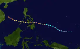
Tropical storm (39–73 mph, 63–118 km/h)
Category 1 (74–95 mph, 119–153 km/h)
Category 2 (96–110 mph, 154–177 km/h)
Category 3 (111–129 mph, 178–208 km/h)
Category 4 (130–156 mph, 209–251 km/h)
Category 5 (≥157 mph, ≥252 km/h)
Unknown


 Extratropical cyclone / Remnant low / Tropical disturbance / Monsoon depression
At 06:00 UTC of December 9, the JTWC started to monitor a low-latitude area of convection in the Pacific Ocean at 4.6°N 142.4°E, located about 350 nautical miles (650 km; 400 mi) to Palau's east-southeast. A broad circulation was identified by the agency, with flaring convection over it. The circulation had a marginal environment with low to moderate wind shear, fair outflow, and warm sea surface temperatures.[1] Despite its given environment, however, the cyclone failed to intensify and dissipated by 06:00 UTC the next day.
Another new area of low pressure formed on December 10. Analysis on the system revealed a degraded and disorganized low-level circulation center.[2][3] Position fixes by 02:30 UTC of December 11 determined that its center forwarded to the north over a developing surface trough while convective bursts occurred around the system.[4] An ASCAT pass featured below gale-force winds on its northwest quadrant.[5]
The Japan Meteorological Agency (JMA) first upgraded the system to a tropical depression with winds of 30 knots (56 km/h; 35 mph) on 00:00 UTC of the next day, followed by the JTWC upgrading the storm's chances of developing to "high" and subsequently issuing a TCFA.[6][7][8] By 03:00 UTC of December 13, the JTWC upgraded the system into a weak tropical depression, highly based on Dvorak ratings of T1.5.[9] Nine hours later, the JMA classified the system as a tropical storm based on Dvorak ratings and named the storm Rai.[10] It was not until 15:00 UTC that day when the JTWC did the same to Rai, as it began tracking northwestwards.[11] Three hours later, Rai began to pass south of Ngulu State, while continuing to intensify and organize.[12][13] By December 14 in the early morning, the system was upgraded into a severe tropical storm by the JMA.[14] By 09:00 UTC, the JTWC noted that the system's cloud tops became warm; however, it further organized while tracking towards the small island country of Palau.[15] The storm entered the Philippine Area of Responsibility around 11:00 UTC (19:00 PHT), and was named Odette by the PAGASA.[16][17] Four hours later, Rai began to exhibit an eye which was first seen on microwave images.[18] The JMA further upgraded the system into a typhoon by the next day, followed by the JTWC three hours later as Rai began to take a westward motion under the influence of a subtropical ridge to its north.[19][20]
Current storm information
As of 12:00 UTC December 15, Typhoon Rai (Odette) is located near 9.0°N 130.2°E or about 333 nmi (617 km; 383 mi) east-northeast of Davao, Philippines. Maximum 10-minute sustained winds are at 75 knots (140 km/h; 85 mph), with gusts up to 105 knots (195 km/h; 120 mph), while maximum 1-minute sustained winds are at 80 knots (150 km/h; 90 mph). The minimum central barometric pressure is 965 hPa (28.50 inHg), and the system is moving west at 10 kn (19 km/h; 12 mph).
For the latest official information, see
Watches and warnings
Preparations
Micronesia
Upon the system's intensification into a tropical depression, a typhoon watch was issued by the US National Weather Service in Tiyan, Guam in Koror and Kayangel while a tropical storm warning was placed for Ngulu Atoll. The island of Yap was placed also under tropical storm watch.[21] This was further upgraded into a typhoon warning for Palau as Rai further intensifies.[22] The alerts for Ngulu and Yap were first canceled by 09:00 UTC of December 14 and six hours later, the typhoon warning were also canceled for Palau.[23][24]
Philippines
The PAGASA began issuing Tropical Cyclone Advisories as early as December 12 given the forecasted track of the storm. In its first advisory, the PAGASA forecasted the possibility of Signal #4 being raised over the Visayas and Mindanao regions, later lowered to Signal #3.[25][26] The PAGASA also forecasted winds of up to 155 km/h (96 mph) prior to landfall.[27] On December 14, storm signals were raised in Caraga and Eastern Visayas as the storm entered the Philippine Area of Responsibility.[17] Starting on the night of December 13, land travel on bound to Visayas, Mindanao, the province of Masbate and Catanduanes were canceled according to an approved request of the Office of the Civil Defense in the country. The Land Transportation Office also placed the same travel restrictions in Mindanao and Luzon as a precaution. All types of vessels are also prohibited to leave the country's ports if there is any Storm Signals raised. Fishermen living near coastal areas were also urged by the country's coast guard to leave their homes "as soon as possible". Other Philippine provinces like Bohol and Aklan were also prepared for possible work cancelations and evacuation premises in regards to the storm. Floating cottages in General Santos City, as well as fishing boats were brought to shore and safety. The vaccination operations across the possible affected areas were earlier suspended by December 20-22.[28][29] Over 23,642 food packs for evacuues were also readied by the country's Department of Social Welfare and Development (DSWD), over 18,665 non-edible items as well as over ₱752,250 (USD$14,950) worth of standby funds.[30] The airline carrier Cebu Pacific also suspended three flights in the country.[31]
Over 10,000 individuals in barangays across Mindanao, Visayas and further north into Southern Luzon were also urged by the National Disaster Risk Reduction and Management Council (NDRRMC) to immediately leave their homes. The whole of Bicol Region were also under red alert starting on December 14. The higher authorities there also warned its people of possible landslides and lahar flow from the Mayon Volcano. Cebu were also under a "state of preparedness" due to the storm. Furthermore, many individuals, of which the majority are going into the Bicol Region in the Parañaque Integrated Terminal Exchange (PITX) were also stranded due to ferry suspensions. Capiz already started voluntary evacuations at this time, first focused on people living in coastal areas.[32]
Four hours after Rai entered the PAR, the PAGASA started to hoist Tropical Cyclone Warning Signal Number 1 for southeastern Eastern Samar and over Surigao Provinces, including the Dinagat Islands.[33][34] This was further extended into some provinces in the Central Visayas and further south of Mindanao, until Agusan del Sur.[35]
See also
- Weather of 2021
- Tropical cyclones in 2021
- Typhoon Mike (1990)
- Typhoon Haiyan (2013)
- Typhoon Phanfone (2019)
References
- Significant Tropical Weather Advisory for the Western and South Pacific Oceans 090600Z-100600Z December 2021 (Report). United States Joint Typhoon Warning Center. 9 December 2021. Archived from the original on 9 December 2021. Retrieved 12 December 2021.
- Significant Tropical Weather Advisory for the Western and South Pacific Oceans Reissued 092200Z-100600Z December 2021 (Report). United States Joint Typhoon Warning Center. 9 December 2021. Archived from the original on 9 December 2021. Retrieved 12 December 2021.
- Significant Tropical Weather Advisory for the Western and South Pacific Oceans 100600Z-110600Z December 2021 (Report). United States Joint Typhoon Warning Center. 10 December 2021. Archived from the original on 10 December 2021. Retrieved 12 December 2021.
- Significant Tropical Weather Advisory for the Western and South Pacific Oceans Reissued 110230Z-110600Z December 2021 (Report). United States Joint Typhoon Warning Center. 11 December 2021. Archived from the original on 11 December 2021. Retrieved 12 December 2021.
- Significant Tropical Weather Advisory for the Western and South Pacific Oceans 110600Z-120600Z December 2021 (Report). United States Joint Typhoon Warning Center. 11 December 2021. Archived from the original on 11 December 2021. Retrieved 12 December 2021.
- "WWJP25 RJTD 120000". Tokyo, Japan: Japan Meteorological Agency. December 12, 2021. Archived from the original on December 12, 2021. Retrieved December 12, 2021.
- Significant Tropical Weather Advisory for the Western and South Pacific Oceans Reissued 120330Z-120600Z December 2021 (Report). United States Joint Typhoon Warning Center. 12 December 2021. Archived from the original on 11 December 2021. Retrieved 12 December 2021.
- Tropical Cyclone Formation Alert (Invest 96W) (Report). United States Joint Typhoon Warning Center. 12 December 2021. Archived from the original on 12 December 2021.
- Prognostic Reasoning for Tropical Depression 28W (Twentyeight) Warning NR 001 (Report). United States Joint Typhoon Warning Center. 13 December 2021. Archived from the original on 13 December 2021. Retrieved 13 December 2021.
- RSMC Tropical Cyclone Prognostic Reasoning No. 7 for TS 2122 Rai (2122) (Report). Japan Meteorological Agency. December 13, 2021. Archived from the original on December 13, 2021. Retrieved December 14, 2021.
- Prognostic Reasoning for Tropical Storm 28W (Rai) Warning NR 003 (Report). United States Joint Typhoon Warning Center. 13 December 2021. Archived from the original on 13 December 2021. Retrieved 14 December 2021.
- "Tropical Storm Rai (28W) Intermediate Advisory Number 3A". forecast.weather.gov. National Weather Service, Tiyan. Archived from the original on 13 December 2021. Retrieved 13 December 2021.
- "Tropical Storm Rai (28W) Intermediate Advisory Number 4". forecast.weather.gov. National Weather Service, Tiyan. Archived from the original on 13 December 2021. Retrieved 13 December 2021.
- RSMC Tropical Cyclone Prognostic Reasoning No. 9 for STS 2122 Rai (2122) (Report). Japan Meteorological Agency. December 14, 2021. Archived from the original on December 13, 2021. Retrieved December 14, 2021.
- Prognostic Reasoning for Tropical Storm 28W (Rai) Warning NR 006 (Report). United States Joint Typhoon Warning Center. 14 December 2021. Archived from the original on 14 December 2021. Retrieved 15 December 2021.
- PAGASA-DOST [@dost_pagasa] (December 14, 2021). "At 7:00 PM today, Severe Tropical Storm RAI entered the Philippine Area of Responsibility and was assigned the domestic name #OdettePH. [...]" (Tweet) – via Twitter.
- "Tropical Cyclone Bulletin #1 for Severe Tropical Storm 'Odette' (Rai)" (PDF). PAGASA. 14 December 2021. Archived from the original (PDF) on 14 December 2021. Retrieved 14 December 2021.
- Prognostic Reasoning for Tropical Storm 28W (Rai) Warning NR 007 (Report). United States Joint Typhoon Warning Center. 14 December 2021. Archived from the original on 14 December 2021. Retrieved 15 December 2021.
- RSMC Tropical Cyclone Prognostic Reasoning No. 13 for TY 2122 Rai (2122) (Report). Japan Meteorological Agency. December 14, 2021. Archived from the original on December 15, 2021. Retrieved December 14, 2021.
- Prognostic Reasoning for Tropical Storm 28W (Rai) Warning NR 009 (Report). United States Joint Typhoon Warning Center. 15 December 2021. Archived from the original on 15 December 2021. Retrieved 15 December 2021.
- "Tropical Depression 28W Advisory Number 1". forecast.weather.gov. National Weather Service, Tiyan. Archived from the original on 13 December 2021. Retrieved 13 December 2021.
- "Tropical Storm Rai (28W) Advisory Number 4". forecast.weather.gov. National Weather Service, Tiyan. Archived from the original on 14 December 2021. Retrieved 15 December 2021.
- "Tropical Storm Rai (28W) Advisory Number 6". forecast.weather.gov. National Weather Service, Tiyan. Archived from the original on 15 December 2021. Retrieved 15 December 2021.
- "Tropical Storm Rai (28W) Advisory Number 7". forecast.weather.gov. National Weather Service, Tiyan. Archived from the original on 15 December 2021. Retrieved 15 December 2021.
- "Tropical Cyclone Advisory #1 for Tropical Depression" (PDF). PAGASA. 12 December 2021. Archived from the original (PDF) on 12 December 2021. Retrieved 12 December 2021.
- "Tropical Cyclone Advisory #2 for Tropical Depression" (PDF). PAGASA. 12 December 2021. Archived from the original (PDF) on 12 December 2021. Retrieved 12 December 2021.
- "Tropical Cyclone Advisory #5 for Tropical Storm 'Rai'" (PDF). PAGASA. 13 December 2021. Archived from the original (PDF) on 13 December 2021. Retrieved 13 December 2021.
- "PCG: Hindi na papayagang bumiyahe ang lahat ng klase ng barko kapag may storm signal na" [PCG: All types of ships will no longer be allowed to sail when there is a storm signal]. GMA News (in Tagalog). December 14, 2021. Retrieved December 15, 2021.
- "Iba't ibang lugar, naghahanda na sa Bagyong Odette na nasa PAR na" [Various places are already preparing for Typhoon Odette which is already in PAR]. GMA News (in Tagalog). December 13, 2021. Retrieved December 14, 2021.
- "DSWD prepares relief goods in Central, Eastern Visayas ahead of Odette landfall". GMA News. December 14, 2021. Retrieved December 15, 2021.
- "Cebu Pacific cancels flights due to tropical storm". GMA News. December 14, 2021. Retrieved December 15, 2021.
- "10,000 brgys. sa Mindanao, Visayas, at Southern Luzon, pinaghahandang palikasin ng NDRRMC | BT" [10,000 brgys. in Mindanao, Visayas, and Southern Luzon, NDRRMC prepares to mobilize | BT]. GMA News (in Tagalog). December 15, 2021. Retrieved December 15, 2021 – via Youtube.
- "PAGASA: Severe Tropical Storm Odette enters PAR". GMA News. December 14, 2021. Retrieved December 15, 2021.
- "Signal No. 1 raised over parts of Eastern Samar, Surigao provinces due to Odette". GMA News. December 14, 2021. Retrieved December 15, 2021.
- "Odette slightly intensifies, Signal No. 1 raised over 15 provinces". GMA News. December 15, 2021. Retrieved December 15, 2021.
External links
 |
Wikimedia Commons has media related to Typhoon Rai. |
- JMA General Information of Typhoon Rai (2122) from Digital Typhoon
- JMA Best Track Data (Graphics) of Typhoon Rai (2122)
- JTWC Best Track Data of Typhoon 28W (Rai)
- 28W.RAI from the U.S. Naval Research Laboratory
Tropical cyclones of the 2021 Pacific typhoon season | ||||||||||||||||||||||||||||||||||||||||||||||||||||||||||||||||||||||||||||||||||||
|---|---|---|---|---|---|---|---|---|---|---|---|---|---|---|---|---|---|---|---|---|---|---|---|---|---|---|---|---|---|---|---|---|---|---|---|---|---|---|---|---|---|---|---|---|---|---|---|---|---|---|---|---|---|---|---|---|---|---|---|---|---|---|---|---|---|---|---|---|---|---|---|---|---|---|---|---|---|---|---|---|---|---|---|---|
 |
| |||||||||||||||||||||||||||||||||||||||||||||||||||||||||||||||||||||||||||||||||||
| ||||||||||||||||||||||||||||||||||||||||||||||||||||||||||||||||||||||||||||||||||||