Tutukaka
Tutukaka (Māori: Tūtūkākā)[1] is a locality on the east coast of Northland, New Zealand, in an area commonly referred to as the Tutukaka Coast which includes Ngunguru and Matapouri.[2] The city of Whangarei is to the southwest. The residential areas of Tutukaka fringe the hills surrounding Tutukaka Harbour, which has a history as a local fishing port and hosts Tutukaka's marina. The Māori name comes from the term tūtū kākā, which means a parrot (kākā) snaring tree (tūtū).[3][4]
Tutukaka | |
|---|---|
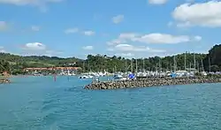 Tutukaka marina | |
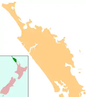  Tutukaka | |
| Coordinates: 35°36′38″S 174°31′28″E | |
| Country | New Zealand |
| Region | Northland Region |
| District | Whangarei District |
As the closest marina to the Poor Knights Islands, Tutukaka is the base for boat tours for diving and snorkelling in the waters around these islands, a protected marine reserve. At the peak of the busy summer months, Tutukaka's population swells from around 600 permanent residents to over 2,400.[5] A walking track leads from Tutukaka to a small lighthouse at Tutukaka Head (South Gable).
Notes
- "Ngā Kōrero Whakahoki Mahara: Ngātiwai Stories We Remember" (PDF). Ngātiwai Education. 2015. Retrieved 23 April 2021.
- "Tutukaka Coast". Whangarei District Council. Retrieved 19 July 2018.
- Best, Elsdon (1977) [1942]. "The kaka or brown parrot (Nestor meridionalis)". Forest Lore of the Maori. Retrieved 23 April 2021.
- "Kaka at Tawapou: The importance of planting natives for the birds". Tawapou Coastal Natives. Retrieved 23 April 2021.
- "Coastal Peak Population Survey" (PDF). Whangarei District Council. September 2014. Retrieved 19 July 2018.
External links
 |
Wikimedia Commons has media related to Tutukaka. |