Badin District
The Badin District (Sindhi: ضلعو بدين, Urdu: ضلع بدین) is a district in the Sindh province of Pakistan. The total area of the district is 6,726 square kilometers.[2] Headquartered at the city of Badin, the district is situated between 24°-5` to 25°-25` north latitude and 68 21’ to 69 20’ east longitude and is bounded on the north by the Tando Allahyar District, Northwest by the Hyderabad District, on the east by Mirpurkhas and Tharparkar districts, on the south by the Kutch district of India, and on the west by Sujawal and Tando Muhammad Khan District.
Badin District
| |
|---|---|
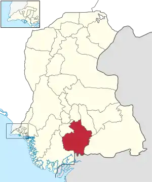 Badin is located in the south of Sindh | |
| Country |  Pakistan Pakistan |
| Province |  Sindh Sindh |
| Headquarters | Badin |
| Area | |
| • Total | 6,726 km2 (2,597 sq mi) |
| Population (2017)[1] | |
| • Total | 1,804,516 |
| • Density | 270/km2 (690/sq mi) |
| Time zone | UTC+5 (PST) |
| Number of Tehsils | 6 |
History
Badin was one of the centers of the center of the ancient Indus Valley Civilization. Islam came into the region by 711 CE. The areas remained under the control of the Islamic caliphate until it came under control of the Ghaznavids. In 1592, Sindh came under the direct rule of the Mughal emperors.[3]
Administration
List of Talukas
The district is administratively subdivided into the following talukas:[4]
With the introduction of the devolution system, the talukas have been subdivided into the Union Councils numbering 49, Tapas 109 and Dehs 511.
List of Union Councils
Badin District includes the following Union Councils:[5]
| UC Name | Population |
|---|---|
| Badin-I | 41,795 |
| Badin-II | 42,984 |
| Badin-III | 45,928 |
| Muhammad Khan Bhurgri | 38,991 |
| Kadi Kazia | 38,456 |
| Luari Sharif | 33,557 |
| Nindo | 43,601 |
| Abdullah Shah | 44,627 |
| Mithi-III | 44,485 |
| Kadhan | 39,531 |
| Seerani | 43,200 |
| Bhugra Memon | 42,592 |
| Matli-I | 44,098 |
| Matli-II | 35,373 |
| Phalkara | 45,949 |
| Malhan | 45,538 |
| Haji Sawan | 34,115 |
| Manik Laghari | 45,953 |
| Thari | 47,682 |
| Tando Ghulam Ali | 42,018 |
| Ghulab Laghari | 33,953 |
| Dumbalo | 52,212 |
| Helepota | 45,241 |
| Budho Qambrani | 53,555 |
| Tando Bago | 32,709 |
| Pahar Marri | 34,208 |
| Chhabralo | 37,551 |
| Khadhero | 45,320 |
| Dadah | 37,000 |
| Khoski | 39,757 |
| Dei Jerkis | 41,454 |
| Khalifo Qasim | 37,595 |
| Pangrio | 38,897 |
| Khairpur Ghumbo | 41,119 |
| Golarchi/Fazal Rahu | 39,927 |
| Ahmed Rajo | 46,152 |
| Rahuki | 29,996 |
| Kario Ghanwhar | 26,849 |
| Tarai | 46,005 |
| Gharo | 38,546 |
| Khorwah | 39,475 |
| Dubi | 39,975 |
| Talhar | 39,658 |
| Peeroo Lashari | 47,020 |
| Saeed Pur | 45,157 |
| Rajo Khanani | 49,000 |
In 2013, the number of union councils in the district was increased to 68.[6]
List of Dehs
The following is a list of Badin District's 511 dehs, organised by taluka:[7]
- Badin Taluka (142 dehs)
- Abri
- Achh
- Achhro
- Akro
- Aminariro
- Andhalo
- Angri
- Babralo-under sea
- Badin
- Baghar
- Bagreji
- Bakho Khudi
- Bandho
- Bano
- Behdmi
- Bhambhki
- Bhaneri
- Bidhadi
- Bijoriro
- Bokhi
- Booharki
- Borandi
- Buxa
- Chandhadi
- Chanesri
- Charo
- Cheerandi
- Chhel
- Chobandi
- Chorhadi
- Chorhalo
- Daleji
- Dandhi
- Daphri
- Dasti
- Dhandh
- Dharan
- Dheenghar
- Doonghadi
- Gabarlo
- Gad
- Gagro
- Ghurbi
- Githo
- Gujjo
- Gurho
- Jakhralo
- Jakhri
- Janath
- Janjhli
- Janki
- Jhagri
- Jhalar
- Jhol khasi
- Jhurkandi
- Kadhan
- Kadi kazia
- Kahlifa
- Kak
- Kalhori
- Kamaro
- Kand
- Kandri
- Karabhari
- Keerandi
- Khakhar
- Khalso
- Khambro
- Kheerdahi
- Khudi
- Khurhadi
- Khuro
- Kumbhairo
- Kunar
- Lohan
- Lao
- Lareri
- Loon Khan
- Luari Sharif
- Lundo
- Majja Basri
- Makhandi
- Makra
- Malki
- Marai
- Mard
- Markhan
- Mirzapur
- Mithi
- Mithi-2
- Mithi-3
- More
- Moreri
- Morhadi
- Moro
- Nangarkhet
- Nangro
- Nareri
- Nindo Shaher
- Odha
- Ojhri
- Padhar
- Pado
- Pahori
- Pakhothar
- Palh
- Panchi
- Panhwarki
- Pano
- Pano Baeed
- Pano Baqir
- Pano Lundki
- Pano Mir Khan
- Patar
- Pateji
- Patiari
- Qaimpur
- Rat
- Roonghadi
- Sando
- Sanghar
- Sanjra
- Sarahadi
- Saroro
- Seerani
- Setha
- Sheikhpur
- Sialki
- Siantri
- Siarsi
- Singari
- Sonhar
- Sutiari
- Tali
- Thath
- Vidhri
- Wagodaho
- Wahryaro
- Waryaso
- Matli Taluka (98 dehs)
- Aghamano
- Ali pur
- Amarlo
- Arain
- Bambhnai
- Baran
- Barasar
- Bediro
- Bhadari
- Buhro Jagir
- Buhro Rayati
- Chakra
- Chan Ganga
- Chansonrani
- Chan-sorahadi
- Chaogazo
- Choretani
- Dasti
- Dadhar
- Dakaro
- Dariri
- Daro sendi
- Deero muhabat
- Dembyari
- Dhabhi
- Dilo-dero
- Diyal
- Doomani
- Dumbalo
- Gari Bhri
- Ghari Lundi
- Gharo
- Gharo Sarmast
- Gopalo
- Gorano
- Gujo
- H. Karam Ali
- Hanjar
- Jarki
- Jehajani
- Juneja
- Kalwari
- Kandrahki
- Kangni
- Kanheri
- Kari Muhammad Ali
- Kari sain Dad
- Kariyano
- Kathore
- Keenjhar
- Khaberlo
- Khachar
- Khad Khuhi
- Khairwah
- Khareri
- Khari, Sindh
- Khariyon
- Khathore
- Khori
- Khudi
- Labni
- Lakhadi
- Lanyari
- Lorer
- Lundano
- Maban
- Malhan
- Mangria
- Matli
- More
- Morhadi
- Nathu
- Pabni
- Padhar
- Paee
- Paniro
- Panjm Hisso
- Phulejani
- Rain
- Rohiro
- Sando
- Saonro
- Sehrat
- Senhor
- Sikni
- Sita
- Sore
- Sorhadi
- Sun
- T.G Ali`
- Talho
- Talhyari
- Tali
- Thari
- Udhejani
- Vee
- Waghrayi
- Wanji
- Shaheed Fazil Rahu Taluka (97 dehs)
- Agri
- Ahmed rajo-1
- Ahmed rajo-2
- Ahmed rajo-3
- Ahmed rajo-4
- Ahmed rajo-5
- Ahmed rajo-6
- Akai
- Akri Jagir
- Akri-1
- Akri-2
- Aseli
- Bari
- Barodari
- Bukerani
- Cahkari
- Chachh
- Dadharko
- Dandho
- Dasarki
- Dubi
- Fatehpur
- Ghanwarah
- Gharo
- Girhari-1
- Girhari-2
- Girhari-3
- Girhari-4
- Girhari-5
- Githo
- Golarchi
- Gujhari
- Jakheji 1 & 2
- Jhabiro
- Jhol
- Jhol-2
- Jhole-1
- Jhole-2
- Jhole-3
- Jhole-4
- Jhole-5
- Jhole-6
- Kadh
- Kaheki
- Kakejani
- Kand
- Kandeyari
- Kario 1 & 2
- Khathar
- Kharch
- Khareyoon
- kharoDabo
- Khebrani
- Kheeryoon
- Khero Bhataro
- Khersari
- Khorwah
- Khudh
- Kinder Jageer
- Koryani
- Lakhi
- Lakri
- Lashkarnani
- Lorhad
- Malira
- Mariwasayo-1
- Mariwasayo-2
- Maroo jat
- Minyoon
- Mitho Dabo
- Miyano Karrath
- Mukhdoompur
- Mulki
- Narri
- Narbut
- Nohiki
- Nukarji-1
- Nuqarji-2
- Odherki
- Padheryoon
- Patihal
- Phitoon
- Rahuki
- Rari-1
- Rari-2
- Rari-3
- Rari-4
- Rari-5
- Rip
- Saleh abad
- Samki
- Shekhano
- Sodhki
- Sorhadi
- Suteyari
- Tajhedi
- Tarai
- Walhar
- Talher Taluka (55 dehs)
- Bagerki
- Baghlani
- Bhetaro
- Bohrro I
- Bohrro II
- Bohrro III
- Bohrro IV
- Chachari
- Chanri
- Chick
- Dabgro
- Dabhrro
- Dato Jamali
- Daurung
- Dedki
- Doro Nero
- Dourmano
- Gaheki
- Golarri
- Gonho
- Kanderi
- Khanoat
- Kocho Sajan Sawai
- Kohar
- Koteri
- Lundki
- More
- Morjhar
- Mughal Hafiz
- Munahaiki
- Nar
- Nawabed
- Paathroon
- Perharki
- Phosana
- Phulhadion
- Raheji
- Rembhan
- Rip
- Rojherlei
- Saidpur
- Sajan
- Sajan pur
- Sandhki
- Sausi
- Seri
- Shakani
- Shorki
- Talhar
- Vassarki
- Vidh
- Vidh
- Walhar
- Wasi Adil
- Wasi Sajjan
- Tando Bago Taluka (110 dehs)
- Adori
- Ahmedani
- Akore
- Ali abad
- Amar Nar
- Aqil
- Bagh Shahmir
- Banghar
- Baxo Kaloi
- Beero Weran
- Belaro
- Bhryoon
- Bohri
- Chandheli-1
- Chandheli-11
- Chandheli-111
- Changho
- Char
- Charvo
- Chavra
- Chhabralo
- Chhachh
- Chhan
- Choubandi
- Dadah
- Dambharlo
- Dando
- Dei
- Dei jarkas
- Dhanjol
- Dhoro Kaka Noro
- Dhubni
- Digh
- Domhar
- Duz
- Fateh Pur
- Fato Qambrani
- Gad
- Gaheji
- Girathri
- Gujo
- Hajar Hadi
- Hameera
- Har
- Higorjani
- Hothair
- Jal Mori
- Jesar
- Kahdharo
- Kak-1
- Kak-11
- Kak-111
- Kamaro
- Kang
- Kangpir
- Kapoori
- Kariyano
- Katadaho
- Katal
- Khadi Adat
- Khado
- Khahi Beero
- Khairpur
- Khalso
- Khanah
- Khari Khabarlo
- Kheerdahi
- Kherol
- Khoro
- Khoski
- Khureri
- Korahi
- Liar
- Machandi
- Machori
- Mato
- Mena
- Mesadi
- Mohna
- Morahadi
- Moro
- Motna
- Oil Pur
- Panu Nau
- Pharho
- Phull
- Phyari
- Pir Misri
- Piror
- Potho
- Potho Nar
- Rail Tarai
- Rajori-1
- Rajori-111
- Ropari
- Saddiq
- Sangi
- Senhaho
- Sonhar
- Sonhari
- Tando Bago
- Tayab Sehto
- Thorki
- Thorlo
- Thui
- Tori
- Toryano
- Uanrki
- Vee Bahadur
- Waghdahi
Demographics
It had a population of 1,136,636, in 1998, of which 16.42% were Urban.[8] It increased to 1,804,516 in the census of 2017.[9]
Religion
Religion in Badin district (2017 Census)[10][lower-alpha 1]
Islam(76%) is the dominant religion in Badin district. Hindus form 23.6% of the population.[10]
Education
The University of Sindh offers 4- year (8- Semester) bachelor's degree programs in Business Administration, Commerce and Computer Science, PGD. Computer Science and B.Ed., M.Ed. & M.A. (Education).[11]
Economy
Nearly 83% of the population lives in the rural areas with farming as the main source of livelihood. The district is irrigated by Indus River through the Akram Wah, Phuleli and Guni Canals of Kotri Barrage and Nasir Canal of Sukkur Barrage. Main Crops are Sugar Cane, Rice, Tomato, Wheat and Sunflower. There are six Sugar Mills and 30 Rice Husking mills in the District. The Oil fields in the Badin district produces nearly 50% of total production of crude oil of Pakistan.[12]
Railways
The main line runs from Badin to Hyderabad through the Matli taluka.[2]
Badin Coal Field
Spread at the area of 1,110sq.km, 'Badin Coal Field' reserves around 1.358 billion metric tons of coal.[13]
References
- "DISTRICT WISE CENSUS RESULTS CENSUS 2017" (PDF). www.pbscensus.gov.pk. Archived from the original (PDF) on 2017-08-29. Retrieved 2017-09-03.
- Planning and Development Department, Sindh Government. Archived 2011-08-12 at the Wayback Machine Retrieved 10 June 2010
- History, Badin. "Badin history". YesPakistan. Archived from the original on 17 November 2011. Retrieved 8 November 2013.
- Local Govt. Department of Sindh - District of Badin Archived 2006-02-20 at the Wayback Machine
- "Union Council wise Thematic Analysis". Department of Health, Government of Sindh. Retrieved 23 May 2021.
- "All eight town committees of Badin district restored". Dawn. 2013. Retrieved 23 May 2021.
- "List of Dehs in Sindh" (PDF). Sindh Zameen. Retrieved 22 March 2021.
- "Urban Resource Centre". Archived from the original on 2006-08-30. Retrieved 2006-10-07.
- "Badin District". Retrieved 4 August 2021.
- University, Sindh. "Laar Campus of University of Sindh". University of Sindh. Archived from the original on 12 December 2013. Retrieved 8 November 2013.
- EconomyBadin, Economy. "Government of Sindh". Government of Sindh. Archived from the original on 10 October 2018. Retrieved 26 March 2019.
- Badin, Coal Field. "Coal Field Badin". Sindh Coal. Retrieved 8 November 2013.
- Hinduism includes Scheduled Caste Hindus and Islam includes Ahmadiyya; which are counted separately in the Census
Authority control  | |
|---|---|
| General | |
| National libraries | |