Hyderabad District, Sindh
Haiderābād District (Sindhi: ضلعو حيدرآباد Urdu: ضلع حیدرآباد), pronunciation is a district of Sindh, Pakistan. Its capital is the city of Hyderabad. The district is the second most urbanized in Sindh, after Karachi, with 80% of its residents live in urban areas.[2]
Hyderabad
| |
|---|---|
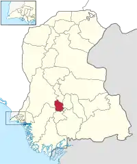 Map of Sindh with Hyderabad District highlighted | |
| Country |  Pakistan Pakistan |
| Province |  Sindh Sindh |
| Headquarters | Hyderabad |
| Government | |
| • Last Deputy Commissioner | Rizwan Ahmed |
| Population (2017)[1] | |
| • Total | 2,199,463 |
| Time zone | UTC+5 (PKT) |
| Number of Tehsils | 4 |
| Website | www.hyderabad.gov.pk |
Geography
Hyderabad District is 104,877 hectares in size.[3] 14,250 hectares of the district are under wheat cultivation, with a total annual production of over 55,000 tonnes.[3]
Administration and government
The city of Hyderabad is where the district headquarters were located and the district government used to be seated. The last Deputy Commissioner of the district was Rizwan Ahmed.[4] Until the early 1970s the district included all the four districts mentioned above as well as the Badin district. This administrative setup was demolished by former President Pervez Musharraf in 2001 when he introduced the local body government.
In 2005 , three new districts- Tando Muhammad Khan, Matiari and Tando Allahyar districts were formed out of the Hyderabad district.[5]
Demographics
The predominantly Muslim population supported Muslim League and Pakistan Movement. After the independence of Pakistan in 1947, the minority Hindus and Sikhs migrated to India while the Muslim refugees from India settled in the Hyderabad District.
The population of the district was enumerated at 2,199,000 at the 2017 Census.
Language
Languages of Hyderabad district(2017 Census)[6]
According to the 2017 census, around equal number of people spoke Sindhi and Urdu as their mother tongue. Punjabi and Pashto are spoken by a small minority of people.[6]
Religion
Religion in Hyderabad district (2017 Census)[6][lower-alpha 1]
Islam (91%) is the dominant religion in Hyderabad district. Hindus form about 8 % of the population, according to the 2017 Census.[6]
List of Dehs
The following is a list of Hyderabad District's dehs, organised by taluka:[7]
- Hyderabad Taluka (70 dehs)
- Abri
- Agheemani
- Almani
- Alni
- Amilpur
- Barechani
- Barham
- Bhido Jagar
- Bhido Rayati
- Bhinpur
- Bilori
- Bohiki
- Boochki Jagir
- Boochki Rayati
- Buxo laghari
- Chacha Detha
- Chukhi
- Dachrapur
- Dali Nandi
- Dali Wadi
- Damanchani Rayati
- Dhamanchani Jagir
- Ghaliyoon
- Ghotana
- Gujjan
- Gul Mohd Thoro
- Halepota
- Hatri
- Hotki
- Hussain Khan Thoro
- Kajhur
- Kathri
- Kathro
- Khanpota
- Khunjejani
- Kunner
- Lashari
- Liyar Jagir
- Mati
- Miyano
- Moharo
- Moolan
- Mori Jagir
- Mori Rayati
- Mulki
- Narejani
- Noorai Jagir
- Noorai Rayati
- Panhwari
- Pasaikhi
- Patbhari
- Patoro
- Raees
- Rahooki
- Rajpari
- Rukanpur
- Sahita
- Sanhwar
- Seri Jagir
- Seri Rayati
- Sipki Jagir
- Sipki Rayati
- Sukhpur
- Takio Jeewan Shah Jagir
- Takio Jeewan Shah Rayati
- Tando Fazal
- Tando Qaiser
- Thaheem
- Theba
- Widh
- Qasimabad Taluka (4 dehs)
- Jamshoro
- Mirzapur
- Sari
- Shah Bukhari
- Latifabad Taluka (10 dehs)
- Bora reyati
- Ganjo Takar
- Giddu Bandar
- Goondar
- Khater
- Lakhi Keti
- Malh
- Mehrani
- Met Khan
- Nareja
- Hyderabad City Taluka (4 dehs)
- Foujgah
- Ghanghra
- Gujjo
- Hyderabad
See also
Notes
- Hinduism includes Scheduled Caste Hindus and Islam includes Ahmadiyya; which are counted separately in the Census
References
- "DISTRICT WISE CENSUS RESULTS CENSUS 2017" (PDF). www.pbscensus.gov.pk. Archived from the original (PDF) on 2017-08-29. Retrieved 2017-09-03.
- Azfar, Sara. "SINDH SECONDARY CITIES URBAN SECTOR ASSESSMENT" (PDF). URBAN MUNICIPAL SERVICES. ASIAN DEVELOPMENT BANK. Archived from the original (PDF) on 26 February 2017. Retrieved 15 December 2017.
- Siyal, Altaf Ali (January 2015). "Remote Sensing and GIS based wheat crop acreage and yield estimation of district Hyderabad, Pakistan". Mehran University Research Journal of Engineering and Technology. Retrieved 14 December 2017.
- "BBC News - SOUTH ASIA - Pakistan's district commissioners bow out". news.bbc.co.uk. Retrieved 11 April 2018.
- "Three new districts carved out of Hyderabad". TheDawn. 5 April 2005. Retrieved 31 July 2021.
- "Hyderabad District". Retrieved 6 August 2021.
- "List of Dehs in Sindh" (PDF). Sindh Zameen. Retrieved 22 March 2021.
Bibliography
- 1998 District census report of Hyderabad. Census publication. 59. Islamabad: Population Census Organization, Statistics Division, Government of Pakistan. 1999.
 |
Wikimedia Commons has media related to Hyderabad District, Pakistan. |
Provincial capital: Karachi | ||
| Banbhore |  | |
| Hyderabad | ||
| Karachi | ||
| Larkana | ||
| Mirpur Khas | ||
| Sukkur | ||
| Shaheed Benazir Abad | ||
Authority control  | |
|---|---|
| General | |
| National libraries | |