Cardston County
Cardston County is a municipal district in southern Alberta, Canada. It is located in Census Division 3 around the Town of Cardston.
Cardston County | |
|---|---|
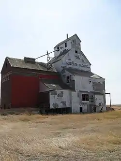 Oldest grain elevator in Alberta, located in Raley | |
 Logo | |
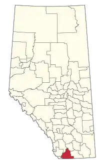 Location within Alberta | |
| Country | Canada |
| Province | Alberta |
| Region | Southern Alberta |
| Census division | 3 |
| Established | 1954 |
| Incorporated | 1999 (County) |
| Government | |
| • Reeve | Randy Bullock |
| • Governing body | Cardston County Council |
| • Administrative office | Cardston |
| Area (2016)[2] | |
| • Land | 3,429.82 km2 (1,324.26 sq mi) |
| Population (2016)[2] | |
| • Total | 4,481 |
| • Density | 1.3/km2 (3/sq mi) |
| Time zone | UTC−7 (MST) |
| • Summer (DST) | UTC−6 (MDT) |
| Website | cardstoncounty.com |


The municipal district was established on January 1, 1954, through the amalgamation of the Municipal District of Sugar City No. 5 and part of the Municipal District of Cochrane No. 6. On January 1, 2000, the name was changed from Municipal District of Cardston No. 6 to Cardston County[3]
Geography
Communities and localities
|
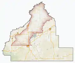
The following urban municipalities are surrounded by Cardston County.[4]
|
The following hamlets are located within Cardston County.[4]
|
The following localities are located within Cardston County.[5]
- Localities
|
|
- Other places
Demographics
In the 2016 Census of Population conducted by Statistics Canada, Cardston County recorded a population of 4,481 living in 1,043 of its 1,260 total private dwellings, a 7.5% change from its 2011 population of 4,167. With a land area of 3,429.82 km2 (1,324.26 sq mi), it had a population density of 1.3/km2 (3.4/sq mi) in 2016.[2]
In the 2011 Census, Cardston County had a population of 4,167 living in 1,032 of its 1,171 total dwellings, a 3.2% change from its 2006 population of 4,037. With a land area of 3,414.87 km2 (1,318.49 sq mi), it had a population density of 1.2/km2 (3.2/sq mi) in 2011.[8]
The population of Cardston County according to its 2008 municipal census is 4,266.[9]
References
- "Municipal Officials Search". Alberta Municipal Affairs. May 9, 2019. Retrieved October 1, 2021.
- "Population and dwelling counts, for Canada, provinces and territories, and census subdivisions (municipalities), 2016 and 2011 censuses – 100% data (Alberta)". Statistics Canada. February 8, 2017. Retrieved February 8, 2017.
- Municipal Profile Archived 2006-10-05 at the Wayback Machine - Alberta Municipal Affairs
- "Specialized and Rural Municipalities and Their Communities" (PDF). Alberta Municipal Affairs. January 6, 2021. Retrieved September 29, 2021.
- "Standard Geographical Classification (SGC) 2006, Economic Regions: 4803001 - Cardston County, geographical codes and localities, 2006". Statistics Canada. 2010-03-05. Archived from the original on 2013-05-25. Retrieved 2012-08-11.
- Geo-Administrative Areas (Hamlet, Locality and Townsite Culture Points) (Geodatabase layer) (Map). AltaLIS. October 26, 2020. Retrieved October 2, 2021.CS1 maint: date and year (link)
- Woolford Flat
- "Population and dwelling counts, for Canada, provinces and territories, and census subdivisions (municipalities), 2011 and 2006 censuses (Alberta)". Statistics Canada. February 8, 2012. Retrieved February 8, 2012.
- Alberta Municipal Affairs (September 15, 2009). "Alberta 2009 Official Population List" (PDF). Retrieved September 12, 2010.
External links

Places adjacent to Cardston County | |
|---|---|




.svg.png.webp)
