Municipal District of Bighorn No. 8
The Municipal District of Bighorn No. 8 is a municipal district (MD) situated in Census Division No. 15 of Alberta, Canada. It is located between Calgary and Banff National Park, north of Kananaskis Improvement District. Highway 1 (the Trans-Canada Highway) passes through the municipal district.
Municipal District of Bighorn No. 8 | |
|---|---|
 Seal | |
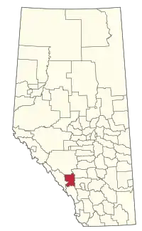 Location within Alberta | |
| Country | Canada |
| Province | Alberta |
| Region | Calgary Region |
| Census division | 15 |
| Incorporated | 1988 |
| Government | |
| • Reeve | Dene Cooper |
| • Governing body | M.D. of Bighorn Council |
| • Administrative office | Exshaw |
| Area (2016)[2] | |
| • Land | 2,761.18 km2 (1,066.10 sq mi) |
| Population (2016)[2] | |
| • Total | 1,334 |
| • Density | 0.5/km2 (1/sq mi) |
| Time zone | UTC−7 (MST) |
| • Summer (DST) | UTC−6 (MDT) |
| Website | mdbighorn.ca |


It was created as a municipal district on January 1, 1988 from the former Improvement District No. 8.[3] The Town of Canmore lies adjacent to the municipal district to the southwest.
Communities and localities
|
The following urban municipalities are surrounded by the MD of Bighorn No. 8.[4]
|
The following hamlets are located within the MD of Bighorn No. 8.[4]
|
The following localities are located within the MD of Bighorn No. 8.[5]
- Localities
- Gap
- Improvement District No. 8
- Jumping Pound (Forest Res)
- Kananaskis
- Spray Lakes
Demographics
In the 2016 Census of Population conducted by Statistics Canada, the MD of Bighorn No. 8 recorded a population of 1,334 living in 556 of its 766 total private dwellings, a -0.5% change from its 2011 population of 1,341. With a land area of 2,761.18 km2 (1,066.10 sq mi), it had a population density of 0.5/km2 (1.3/sq mi) in 2016.[2]
In the 2011 Census, the MD of Bighorn No. 8 had a population of 1,341 living in 547 of its 797 total dwellings, a 6.1% change from its 2006 population of 1,264. With a land area of 2,767.94 km2 (1,068.71 sq mi), it had a population density of 0.5/km2 (1.3/sq mi) in 2011.[6]
References
- Alberta Municipal Affairs: Municipal Officials Search
- "Population and dwelling counts, for Canada, provinces and territories, and census subdivisions (municipalities), 2016 and 2011 censuses – 100% data (Alberta)". Statistics Canada. February 8, 2017. Retrieved February 8, 2017.
- Municipal District of Bighorn No. 8 profile - Alberta Municipal Affairs
- "Specialized and Rural Municipalities and Their Communities" (PDF). Alberta Municipal Affairs. January 6, 2021. Retrieved September 29, 2021.
- "Standard Geographical Classification (SGC) 2006, Economic Regions: 4815015 - Bighorn No. 8, geographical codes and localities, 2006". Statistics Canada. 2010-03-05. Archived from the original on 2011-08-28. Retrieved 2012-08-11.
- "Population and dwelling counts, for Canada, provinces and territories, and census subdivisions (municipalities), 2011 and 2006 censuses (Alberta)". Statistics Canada. February 8, 2012. Retrieved February 8, 2012.
External links
Places adjacent to Municipal District of Bighorn No. 8 | |
|---|---|




.svg.png.webp)

Authority control  | |
|---|---|
| General | |
| National libraries | |