Karo Regency
Karo Regency is a landlocked regency of North Sumatra, Indonesia, situated in the Barisan Mountains. The regency covers an area of 2,127.25 square kilometres (821.34 sq mi) and according to the 2010 census it had a population of 350,479,[2] increasing to 404,998 at the 2020 Census.[3] 60.99% of the regency is forested.[4] Its regency seat is Kabanjahe. The Batak Karo language is spoken in the regency, as well as the Indonesian language. It borders Southeast Aceh Regency in Aceh to the west, Deli Serdang Regency and Langkat Regency to the north, Dairi Regency and Toba Samosir Regency to the south, and Deli Serdang Regency and Simalungun Regency to the east.
Karo Regency
Tanah Karo | |
|---|---|
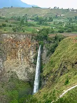 Sipiso-Piso Waterfall in Tongging, Karo Regency | |
 Coat of arms | |
| Motto(s): Pijer Podi | |
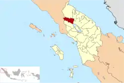 | |
| Country | Indonesia |
| Province | North Sumatra |
| Regency seat | Kabanjahe |
| Government | |
| • Regent | Terkelin Brahmana |
| • Vice Regent | Cory Sebayang |
| • Chairwoman of Council of Representatives | Iriani Tarigan (PDI-P) |
| • Vice Chairmen of Council of Representatives | Sadarta Bukit (Gerindra) and David Kristian Sitepu (Nasdem) |
| Area | |
| • Total | 2,127.25 km2 (821.34 sq mi) |
| Highest elevation | 2,460 m (8,070 ft) |
| Lowest elevation | 200 m (700 ft) |
| Population (2020 Census)[1] | |
| • Total | 404,998 |
| • Density | 190/km2 (490/sq mi) |
| Time zone | UTC+7 (WIB) |
| Website | www |

Economy

The GDP per capita of Karo Regency in 2005 was 11.65 million rupiah, approximately US$1,200. 74% of the population work in agriculture, which comprises 60% of regional GDP.[5] The second-largest sector is government, which comprises 11% of the regional GDP.[6]
Administrative divisions
The regency is divided administratively into seventeen districts (kecamatan), tabulated below with their areas and their populations at the 2010 Census[7] and the 2020 Census.[8] The table also includes the number of administrative villages (rural desa and urban kelurahan) in each district, and its post codes.
| Name | Area in km2 | Pop'n Census 2010[7] | Pop'n Census 2020[9] | Number of villages | Post code |
|---|---|---|---|---|---|
| Mardingding | 267.11 | 17,062 | 19,954 | 12 | 22165 |
| Laubaleng | 252.60 | 17,713 | 20,652 | 15 | 22164 |
| Tigabinanga | 160.38 | 19,900 | 22,395 | 20 | 22162 |
| Juhar | 218.56 | 12,861 | 14,787 | 25 | 22163 |
| Munte | 125.64 | 19,686 | 22,909 | 22 | 22161 |
| Kutabuluh | 195.70 | 10,586 | 12,602 | 16 | 22155 |
| Payung | 47.24 | 10,837 | 12,249 | 8 | 22154 |
| Tiganderket | 86.76 | 13,178 | 14,555 | 17 | 22156 |
| Simpang Empat | 93.48 | 19,035 | 21,355 | 17 | 22150 |
| Naman Teran | 87.82 | 12,796 | 14,622 | 14 | 22151 |
| Merdeka * | 44.17 | 13,310 | 15,580 | 9 | 22153 |
| Kabanjahe | 44.65 | 63,326 | 73,581 | 13 | 22111 - 13115 |
| Berastagi * | 30.50 | 42,541 | 48,244 | 10 | 22152 |
| Tigapanah | 186.84 | 29,319 | 34,263 | 26 | 22170 |
| Dolat Rakyat * | 32.25 | 8,296 | 9,848 | 7 | 22171 |
| Merek | 125.51 | 18,054 | 22,746 | 19 | 22173 |
| Barusjahe * | 128.04 | 22,097 | 24,656 | 19 | 22172 |
| Totals | 2,127.25 | 350,479 | 404,998 | 269 |
Note that four of these districts (indicated by "*") constitute a part of the Medan metropolitan area.
References
- Badan Pusat Statistik, Jakarta, 2021.
- Seta,William J. Atlas Lengkap Indonesia dan Dunia (untuk SD, SMP, SMU, dan Umum). Pustaka Widyatama. p. 9. ISBN 979-610-232-3.
- Badan Pusat Statistik, Jakarta, 2021.
- "Archived copy". Archived from the original on 2011-02-26. Retrieved 2010-11-11.CS1 maint: archived copy as title (link)
- "Archived copy". Archived from the original on 2011-07-21. Retrieved 2010-11-10.CS1 maint: archived copy as title (link)
- "Archived copy". Archived from the original on 2012-03-14. Retrieved 2010-11-10.CS1 maint: archived copy as title (link)
- Biro Pusat Statistik, Jakarta, 2011.
- Badan Pusat Statistik, Jakarta, 2021.
- Badan Pusat Statistik, Jakarta, 2021.

Authority control  |
|---|