Ortigas Avenue
Ortigas Avenue is a 15.5 km (9.6 mi) highway running from eastern Metro Manila to western Rizal. It is one of the busiest highways in Metro Manila, serving as the main thoroughfare of the metro's east–west corridor, catering mainly to the traffic to and from Rizal.
.svg.png.webp) .svg.png.webp) R-5 | |
|---|---|
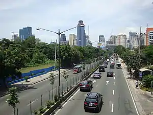 Looking west towards Ortigas Center from IPI | |
| Route information | |
| Length | 15.5 km (9.6 mi) Including extension from Pasig to Antipolo |
| Component highways |
|
| Major junctions | |
| West end | N184 (Granada Street) / Bonny Serrano Avenue at the Quezon City–San Juan boundary |
| East end | .svg.png.webp) N600 (Sen. L. Sumulong Memorial Circle) / N60 (P. Oliveros Street) in Antipolo N600 (Sen. L. Sumulong Memorial Circle) / N60 (P. Oliveros Street) in Antipolo |
| Location | |
| Major cities | San Juan, Mandaluyong, Quezon City, Pasig, Antipolo |
| Towns | Cainta, Taytay |
| Highway system | |
| |
The western terminus of the highway is at the boundary of San Juan and Quezon City. The highway then traverses through Ortigas Center and along the cities of Mandaluyong, Quezon City, and Pasig, followed by the municipalities of Cainta and Taytay, and finally ending in the city of Antipolo.
The portion of Ortigas Avenue from Eulogio Rodriguez Jr. Avenue (C-5) in Pasig to Taytay Diversion Road in Taytay is designated as a component of Radial Road 5 (R-5). The highway is also designated as National Route 60 (N60) and National Route 184 (N184) of the Philippine highway network, respectively.
Route description


Ortigas Avenue starts as a physical continuation of Granada Street past Bonny Serrano Avenue at the boundary of San Juan and Quezon City. It then cuts through San Juan and northeast of Wack Wack Golf and Country Club in Mandaluyong. It crosses EDSA at the EDSA–Ortigas Interchange at the boundary of Mandaluyong and Quezon City, and runs through Ortigas Center, making a slight curve on Meralco Avenue. The avenue soon cuts through Ugong, enters Pasig, and crosses Circumferential Road 5 at the C5–Ortigas Interchange. Past C-5-Ortigas Interchange, it is called Ortigas Avenue Extension. It soon crosses Marikina River and Manggahan Floodway, partially becomes a single carriageway and changing back into a dual carriageway, and then enters Cainta, Rizal past SM City East Ortigas (formerly Ever Gotesco Ortigas). At its intersection with Dr. Sixto Antonio Avenue between the Marikina River and Manggahan Floodway in Rosario, the Manila East Road begins as the Pasig–Cainta Road segment.
It crosses Bonifacio and Felix Avenues at Cainta Junction, where the Manila East Road (Pasig–Cainta Road) segment ends. It then continues to Antipolo and passes over the Kaytikling Junction with Taytay Diversion Road (towards Manila East Road) in Taytay, Rizal. Past Kaytikling, it becomes a component of Corazon C. Aquino Avenue,[1] following a winding route to Antipolo, passing through some residential subdivisions before it ends at its intersection with L. Sumulong Memorial Circle and P. Oliveros Street fronting the Hamaka Park near the Rizal Provincial Capitol. It then continues to downtown Antipolo as P. Oliveros Street, which ends near the Shrine of Our Lady of Peace and Good Voyage and another component of Corazon C. Aquino Avenue that leads to Morong.
Intersections
| Province | City/Municipality | km[2] | mi | Destinations | Notes |
|---|---|---|---|---|---|
| Quezon City–San Juan boundary | 9 | 5.6 | Bonny Serrano Avenue | Traffic light intersection. Continues west as Granada Street. | |
| San Juan | Xavier Street | Former eastbound access for North Greenhills and former westbound access for heavy traffic in the Xavier School vicinity. | |||
| 9 | 5.6 | Madison Street | Traffic light intersection. Access for North Greenhills and the Xavier School-ICA vicinity. | ||
| Roosevelt Street | Traffic light intersection. Access for North Greenhills and West Greenhills. | ||||
| Club Filipino Drive | Traffic light intersection. Provides access to the Greenhills mixed-use development. | ||||
| 10 | 6.2 | Wilson Street | Traffic light intersection. Provides access to the Greenhills mixed-use development. | ||
| San Juan–Mandaluyong boundary | Connecticut Street | Traffic light intersection. Access for West Greenhills and the Greenhills mixed-use development. | |||
| Mandaluyong | 11 | 6.8 | Notre Dame Street. | Eastbound only. Access for Wack-Wack Village. | |
| Holy Cross Street. | Westbound only. Access for Greenhills East. | ||||
| Columbia Street. | Westbound access only. Access for Greenhills East. | ||||
| Mandaluyong–Quezon City boundary | _sign.svg.png.webp) AH 26 (N1) (EDSA) AH 26 (N1) (EDSA) | EDSA–Ortigas Interchange. Traffic light intersection below interchange. Route number change from N184 to N60. | |||
| Quezon City | Arcadia Avenue. | Westbound access only. Access for Arcadia Village. | |||
| ADB Avenue | Traffic light intersection on the eastbound side. | ||||
| Zalameda Street | Westbound access only. Access for Corinthian Gardens. | ||||
| Pasig | Meralco Avenue | Traffic light intersection. | |||
| 13 | 8.1 | Royal Palm Street | Eastbound access only. Access for Valle Verde 4. | ||
| Lanuza Avenue | Traffic light intersection. | ||||
| Green Meadows Avenue | Traffic light intersection. | ||||
| 14 | 8.7 | .svg.png.webp) N11 (E. Rodriguez Jr. Avenue) N11 (E. Rodriguez Jr. Avenue) | C5–Ortigas Interchange. Traffic light intersection under interchange. Western end of R-5 concurrency. | ||
| Rosario Bridge over Marikina River | |||||
| Dr. Sixto Antonio Avenue | Left turns from westbound provided by U-turn under Rosario Bridge. Start of Manila East Road. | ||||
| Amang Rodriguez Avenue | Right-in, right out. Left turns via U-turn slots. | ||||
| 15 | 9.3 | C. Raymundo Avenue / Tramo Street | Left turns provided by U-turn locations | ||
| 15.5 | 9.6 | West Bank Road | Eastbound exit and westbound entrance. U-turn location used for left turns from Sixto Antonio and C. Raymundo intersections. | ||
| Ortigas Bridge over Manggahan Floodway | |||||
| East Bank Road | Westbound exit and eastbound entrance. | ||||
| Buli Creek | Cainta-Buli Bridge | ||||
| Rizal | Cainta | 18 | 11 | .svg.png.webp) N601 (Bonifacio Avenue) / Felix Avenue N601 (Bonifacio Avenue) / Felix Avenue | Cainta Crossing. Traffic light intersection. End of Manila East Road (Rosario–Cainta Road) segment. |
| Sunset Drive | Traffic light intersection | ||||
| 20 | 12 | Hunters ROTC Guerilla Street | |||
| Cainta–Taytay boundary | General A. Ricarte Street / Don Celso Tuason Street | Traffic light intersection | |||
| Taytay | E. Rodriguez Avenue | Traffic light intersection | |||
| 21 | 13 | Taytay Diversion Road / L. Wood Street | Roundabout (Kaytiking Rotunda). Eastern end of R-5 concurrency. | ||
| Antipolo | N600 (Sen. L. Sumulong Memorial Circle) / N60 (P. Oliveros Street) | Eastern terminus | |||
1.000 mi = 1.609 km; 1.000 km = 0.621 mi
| |||||
Name
The road is named after the prominent lawyer and businessman during the American Era, Don Francisco Emilio Barcinas Ortigas Sr. (1875–1935), who was popularly known as "Don Paco".[3][4][5] Its segment from Kaytikling Junction to its terminus in Antipolo is part of Corazon C. Aquino Avenue, named in honor of Corazon Aquino, the 11th President of the Philippines.[1]
References
- Republic Act No. 11045 (29 June 2018), An Act Renaming the Kay Tikling-Antipolo-Teresa-Morong National Road in the Province of Rizal, Traversing Through Barangay Dolores in the Municipality of Taytay up to Barangay Maybancal in the Municipality of Morong, as Corazon C. Aquino Avenue
- "Road and Bridge Inventory". www.dpwh.gov.ph. Retrieved July 31, 2020.
- "Francisco Emilio Barcinas Ortigas (b. - 1935)". Genealogy.
- https://www.townandcountry.ph/people/heritage/who-are-the-most-generous-enduring-families-of-the-philippines-a1590-20161104-lfrm2
- Calero, Javier (June 9, 2016). "The men behind Heneral Luna". Business World Online.
See also
| Expressways |
|  | |||||
|---|---|---|---|---|---|---|---|
| National Roads |
| ||||||
