Rathsun
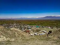
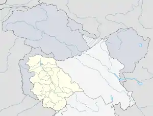
Rathsun or Rathsoon (Kashmiri: رٹھسُن) is a village and block located in the Jammu and Kashmir's Budgam district. It is situated at the base of the Pir Panjal Range of the Himalayas. It falls under the administrative division of tehsil Beerwah one of the nine tehsils of district Budgam. It is about 23.7 km (14.7 mile) via Beerwah-Budgam Road from district headquarters Budgam, 7 km (4.3 mi) from sub-district headquarters Beerwah, known as the Gateway of Doodhpathri and Gateway of Tosamaidan, and 29 km (18 mile) away from Srinagar, the summer capital of Jammu and Kashmir. Magam, known as the Business Hub of Budgam district and the Gateway of Gulmarg, is nearest town to Rathsun which is approximately 4 kilometres (2.5 mi) away.
Rathsun
رَھٹسُن | |
|---|---|
Village | |
 | |
  Rathsun Location in Jammu and Kashmir, India  Rathsun Rathsun (India) | |
| Coordinates: 34°00′20″N 74°35′05″E | |
| Country | India |
| Union territory | Jammu and Kashmir |
| District | Budgam |
| Tehsil | Beerwah |
| Government | |
| • Type | Panchayat |
| Area | |
| • Total | 4.44 km2 (1.71 sq mi) |
| Elevation | 1,595 m (5,233 ft) |
| Population (2011) | |
| • Total | 5,907 |
| • Density | 1,300/km2 (3,400/sq mi) |
| Languages | |
| • Official | Kashmiri, Urdu, Hindi, Dogri, English[1][2] |
| Time zone | UTC+5:30 (IST) |
| PIN | 193401 |
| Vehicle registration | JK04 |
| Sex Ratio | 851 ♀/ 1000 ♂ |
The Sukhnag (Sokhanag) River, known locally as the spring of solace, passes through Rathsun.
Etymology
Local tale says that the name 'Rathsun' is derived from Persian words rath "jealousness" and sun "gold". It is said that the famous saint of Kashmir Sheikh ul Aalam Sheikh Noor din Noorani, while visiting through the village, came across a few residents. While having conversations with them he concluded that: "People are friendly and land is blessed but it would have been gold (sun), if jealousy (rath) would not have been a common trait among locals." So he called it Rathsun.
Geography
The total geographical area of village is 4.44 square kilometres (1.71 sq mi). It is located at an elevation of 1,595 m (5,232 ft) above the sea level. The landscape, mostly the agricultural field area, is made up of plateau-like terraces known as karewas.[3]
Demographics
Population
As of 2011 sensus, the population of Rathsun is 5,907 of which 3,191 are males while the remaining 2,716 are females and a total number of 1488 children below 6 years as per the report. There are about 596 houses in Rathsun village.[4]
Religion
People in all the hamlets of Rathsun follow Islam and the whole of the population of Rathsun belong to Sunni sect of Islam. Most of the people of the village follows the Hanafi School of Thought. Religious education is imparted through Madrassas either early in the morning or in the evening time.
Economy
Much of the local economy is agricultural crops grown include rice, maize, vegetables, apples, walnuts, pears, apricots and almonds. The staple food of the locals is cooked rice, and is served at lunch and dinner. The economy in Rathsun also includes smaller businesses such as shops, shawl work, knit-work, and embroidery.
Due to the large population, Rathsun has a hospital, a marriage hall, a branch of JK Bank including an ATM.
Due to growth in the educational sector, the service sector has also increased professional jobs such as doctors, lawyers, engineers, and civil servants are also increasing in number.
Transport
The nearest airport from Rathsun is Sheikh ul-Alam International Airport. The nearest railway station is the Mazhom railway station.
Education
Schools in Rathsun include both government-run and private schools of varying levels. The 'Government Boys High School' is one of the oldest high school in the area imparting education to the common folks, thus Rathsun enjoys a central position in educational field also. Besides this, a large number of middle and primary schools are also operational in Rathsun.
References
- "The Jammu and Kashmir Official Languages Act, 2020" (PDF). The Gazette of India. 27 September 2020. Retrieved 27 September 2020.
- "Parliament passes JK Official Languages Bill, 2020". Rising Kashmir. 23 September 2020. Retrieved 30 May 2021.
- Lawrence, Walter R., Sir (2005). The valley of Kashmir. New Delhi: Asian Educational Services. ISBN 81-206-1630-8. OCLC 65200978.
- "Census of India: Search Details". censusindia.gov.in. Retrieved 3 August 2021.
External links
 Media related to Rathsoon at Wikimedia Commons
| Subdivisions | |
|---|---|
| Municipalities | |
| Tehsils | |
| Blocks | |
| Tourist attractions |
|
| Villages | |
| Railway | |
| Airport | |