Toktogul District
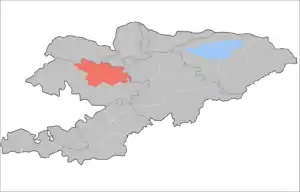
Toktogul (Kyrgyz: Токтогул району) is a district of Jalal-Abad Region in western Kyrgyzstan. The administrative seat lies at Toktogul.[1] Its area is 7,815 square kilometres (3,017 sq mi),[2] and its resident population was 103,310 in 2021.[3]
Toktogul
Токтогул району | |
|---|---|
 Flag  Coat of arms | |
 | |
| Country | Kyrgyzstan |
| Region | Jalal-Abad Region |
| Area | |
| • Total | 7,815 km2 (3,017 sq mi) |
| Population (2021) | |
| • Total | 103,310 |
| • Density | 13/km2 (34/sq mi) |
| Time zone | UTC+6 |
The town and district are named after its most famous son - the musician Toktogul Satylganov. The Toktogul reservoir is a geographical feature of the district and the capital lies on the north shore.
Population
| Year | Pop. | ±% p.a. |
|---|---|---|
| 1970 | 47,024 | — |
| 1979 | 55,711 | +1.90% |
| 1989 | 69,323 | +2.21% |
| 1999 | 77,202 | +1.08% |
| 2009 | 86,306 | +1.12% |
| 2021 | 103,310 | +1.51% |
| Note: resident population; Sources:[2][3] | ||
Cities, rural communities and villages
In total, Toktogul District includes 1 city and 44 settlements in 10 rural communities (ayyl aymagy). Each rural community can consist of one or several villages. The rural communities and settlements in the Toktogul District are:[1][4][5]
- city Toktogul
- Abdy Süyörkulov (seat: Torkent; incl. Kötörmö and Kara-Jygach)
- Aralbaev (seat: Toluk; incl. Almaluu, Noot and Char-Tash)
- Bel-Aldy (seat: Sary-Sögöt; incl. Bel-Aldy and Korgon)
- Jangy-Jol (seat: Jangy-Jol; incl. Aral, Kara-Suu, Komsomol, Kuybyshev and Kyzyl-Tuu)
- Ketmen-Döbö (seat: Terek-Suu; incl. Beke-Chal, Chong-Aryk and Eshsay)
- Kyzyl-Özgörüsh (seat: Kyzyl-Özgörüsh; incl. Ang-Aryk, Bel-Kara-Suu, Buurakan, Jar-Tash, Kamysh-Bashy, Kongur-Ögüz, Kosh-Tash, Orto-Jon, Chech-Döbö, Shayyk and Ak-Jar)
- Nichke-Say (seat: Nichke-Say; incl. Chorgochu)
- Sary-Kamysh (seat: Birlik; incl. Kötörmö)
- Üch-Terek (seat: Üch-Terek; incl. Jetigen, Kyzyl-Uraan, Sargata and Taktalyk)
- Cholpon-Ata (seat: Cholpon-Ata; incl. Ak-Tektir, Balykty, Kara-Künggöy, Kushchu-Suu and Mazar-Suu)
References
- "Classification system of territorial units of the Kyrgyz Republic" (in Kyrgyz). National Statistics Committee of the Kyrgyz Republic. May 2021. pp. 29–30.
- "2009 population and housing census of the Kyrgyz Republic: Jalal-Abad Region" (PDF) (in Russian). National Statistics Committee of the Kyrgyz Republic. 2010. p. 13, 17.
- "Population of regions, districts, towns, urban-type settlements, rural communities and villages of Kyrgyz Republic" (XLS) (in Russian). National Statistics Committee of the Kyrgyz Republic. 2021. Archived from the original on 10 November 2021.
- List of rural communities of Kyrgyzstan Archived 2010-02-09 at the Wayback Machine
- 2012 Law on the transformation of individual urban settlements of the Kyrgyz Republic and relating them to the category of village or city
| North Kyrgyzstan |
|  Raions of Kyrgyzstan | ||||||||||
|---|---|---|---|---|---|---|---|---|---|---|---|---|
| South Kyrgyzstan |
| |||||||||||
This article is issued from Wikipedia. The text is licensed under Creative Commons - Attribution - Sharealike. Additional terms may apply for the media files.