Arkansas statistical areas

The U.S. State of Arkansas currently has 27 statistical areas that have been delineated by the Office of Management and Budget (OMB). On March 6, 2020, the OMB delineated four combined statistical areas, eight metropolitan statistical areas, and 15 micropolitan statistical areas in Arkansas.[1]
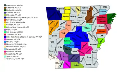
An enlargeable map of the 23 core-based statistical areas in Arkansas.[1]

Statistical areas

The Office of Management and Budget (OMB) has designated more than 1,000 statistical areas for the United States and Puerto Rico.[2] These statistical areas are important geographic delineations of population clusters used by the OMB, the United States Census Bureau, planning organizations, and federal, state, and local government entities.

The OMB defines a core-based statistical area (commonly referred to as a CBSA) as "a statistical geographic entity consisting of the county or counties (or county-equivalents) associated with at least one core[lower-alpha 1] of at least 10,000 population, plus adjacent counties having a high degree of social and economic integration with the core as measured through commuting ties with the counties containing the core."[2] The OMB further divides core-based statistical areas into metropolitan statistical areas (MSAs) that have "a population of at least 50,000" and micropolitan statistical areas (μSAs) that have "a population of at least 10,000, but less than 50,000."[2]

The OMB defines a combined statistical area (CSA) as "a geographic entity consisting of two or more adjacent core-based statistical areas with employment interchange measures[lower-alpha 2] of at least 15%."[2] The primary statistical areas (PSAs) include all combined statistical areas and any core-based statistical area that is not a constituent of a combined statistical area.

Table

The table below describes the 27 United States statistical areas and 75 counties of the State of Arkansas with the following information:[3]

  1. The combined statistical area (CSA) as designated by the OMB.[1]
  2. The CSA population according to 2019 US Census Bureau population estimates.[4]
  3. The core based statistical area (CBSA)[2] as designated by the OMB.[1]
  4. The CBSA population according to 2019 US Census Bureau population estimates [4]
  5. The county name
  6. The county population according to 2019 US Census Bureau population estimates [4]
The 27 United States statistical areas and 75 counties of the State of Arkansas

Combined Statistical Area 2019 Population Core Based Statistical Area 2019 Population County 2019 Population
Little Rock-North Little Rock, AR CSA 908,941 Little Rock-North Little Rock-Conway, AR MSA 742,384 Pulaski County, Arkansas 391,911
Faulkner County, Arkansas 126,007
Saline County, Arkansas 122,437
Lonoke County, Arkansas 73,309
Grant County, Arkansas 18,265
Perry County, Arkansas 10,455
Pine Bluff, AR MSA 87,804 Jefferson County, Arkansas 66,824
Lincoln County, Arkansas 13,024
Cleveland County, Arkansas 7,956
Searcy, AR μSA 78,753 White County, Arkansas 78,753
none Fayetteville-Springdale-Rogers, AR MSA 534,904 Benton County, Arkansas 279,141
Washington County, Arkansas 239,187
Madison County, Arkansas 16,576
Fort Smith, AR-OK MSA 250,368
208,799
Sebastian County, Arkansas 127,827
Crawford County, Arkansas 63,257
Sequoyah County, Oklahoma 41,569
Franklin County, Arkansas 17,715
Jonesboro-Paragould, AR CSA 179,185 Jonesboro, AR MSA 133,860 Craighead County, Arkansas 110,332
Poinsett County, Arkansas 23,528
Paragould, AR μSA 45,325 Greene County, Arkansas 45,325
Hot Springs-Malvern, AR CSA 133,157 Hot Springs, AR MSA 99,386 Garland County, Arkansas 99,386
Malvern, AR μSA 33,771 Hot Spring County, Arkansas 33,771
none Russellville, AR μSA 85,413 Pope County, Arkansas 64,072
Yell County, Arkansas 21,341
Memphis-Forrest City, TN-MS-AR CSA 1,371,039
72,949
Memphis, TN-MS-AR MSA 1,346,045
47,955
Shelby County, Tennessee 937,166
DeSoto County, Mississippi 184,945
Tipton County, Tennessee 61,599
Crittenden County, Arkansas 47,955
Fayette County, Tennessee 41,133
Marshall County, Mississippi 35,294
Tate County, Mississippi 28,321
Tunica County, Mississippi 9,632
Forrest City, AR μSA 24,994 St. Francis County, Arkansas 24,994
none Texarkana, TX-AR MSA 148,761
55,516
Bowie County, Texas 93,245
Miller County, Arkansas 43,257
Little River County, Arkansas 12,259
Batesville, AR μSA 55,267 Independence County, Arkansas 37,825
Sharp County, Arkansas 17,442
Harrison, AR μSA 45,185 Boone County, Arkansas 37,432
Newton County, Arkansas 7,753
Mountain Home, AR μSA 41,932 Baxter County, Arkansas 41,932
Blytheville, AR μSA 40,651 Mississippi County, Arkansas 40,651
El Dorado, AR μSA 38,682 Union County, Arkansas 38,682
Hope, AR μSA 29,784 Hempstead County, Arkansas 21,532
Nevada County, Arkansas 8,252
Camden, AR μSA 28,571 Ouachita County, Arkansas 23,382
Calhoun County, Arkansas 5,189
Magnolia, AR μSA 23,457 Columbia County, Arkansas 23,457
Arkadelphia, AR μSA 22,320 Clark County, Arkansas 22,320
Helena-West Helena, AR μSA 17,782 Phillips County, Arkansas 17,782
none Carroll County, Arkansas 28,380
Johnson County, Arkansas 26,578
Cleburne County, Arkansas 24,919
Logan County, Arkansas 21,466
Conway County, Arkansas 20,846
Polk County, Arkansas 19,964
Ashley County, Arkansas 19,657
Drew County, Arkansas 18,219
Randolph County, Arkansas 17,958
Arkansas County, Arkansas 17,486
Sevier County, Arkansas 17,007
Jackson County, Arkansas 16,719
Marion County, Arkansas 16,694
Van Buren County, Arkansas 16,545
Cross County, Arkansas 16,419
Lawrence County, Arkansas 16,406
Clay County, Arkansas 14,551
Izard County, Arkansas 13,629
Howard County, Arkansas 13,202
Stone County, Arkansas 12,506
Fulton County, Arkansas 12,477
Desha County, Arkansas 11,361
Bradley County, Arkansas 10,763
Pike County, Arkansas 10,718
Scott County, Arkansas 10,281
Chicot County, Arkansas 10,118
Montgomery County, Arkansas 8,986
Lee County, Arkansas 8,857
Prairie County, Arkansas 8,062
Searcy County, Arkansas 7,881
Dallas County, Arkansas 7,009
Monroe County, Arkansas 6,701
Lafayette County, Arkansas 6,624
Woodruff County, Arkansas 6,320
State of Arkansas 3,017,804

See also

Notes

  1. The OMB defines a core as "a densely settled concentration of population, comprising an Urban Area (of 10,000 or more population) delineated by the Census Bureau, around which a core-based statistical area is delineated."[2]
  2. The OMB defines the employment interchange measure as "the sum of the percentage of workers living in the smaller entity who work in the larger entity plus the percentage of employment in the smaller entity that is accounted for by workers who reside in the larger entity."[2]

References

  1. Revised Delineations of Metropolitan Statistical Areas, Micropolitan Statistical Areas, and Combined Statistical Areas, and Guidance on Uses of the Delineations of These Areas (March 6, 2020). "0MB BULLETIN NO. 20-01" (PDF). Office of Management and Budget. Retrieved December 6, 2021.CS1 maint: multiple names: authors list (link)
  2. "2020 Standards for Delineating Core Based Statistical Areas". Office of Management and Budget. July 16, 2021. Retrieved December 6, 2021.
  3. An out-of-state area and its population are displayed in green. An area that extends into more than one state is displayed in teal. A teal population number over a black population number show the total population versus the in-state population.
  4. "Annual Estimates of the Resident Population for Counties in the United States: April 1, 2010 to July 1, 2019". United States Census Bureau, Population Division. April 2020. Archived from the original on March 27, 2020. Retrieved April 9, 2020.

This article is issued from Wikipedia. The text is licensed under Creative Commons - Attribution - Sharealike. Additional terms may apply for the media files.